38 Most Popular Forts in India

There are many forts, magnificent and huge, with a long history, that have survived for centuries and decades, in India. These forts reflect not just the history, but also the architectural brilliance of those times. And if, you too, have a fascination for these marvels that still attract a beeline of tourists. Forts and palaces are an integral part of India. They make the country truly exquisite. All these grand structures have some fascinating stories associated with them. These architectural marvels are loved by tourists who travel through India. Most of these forts tell the stories of bravery and valor of ancient rulers who lived and died in these forts. Here you can find the list of the most popular forts in India. Almost every Indian state has an impressive fort belonging to a different historical time showcasing the architectural style of that period. These forts help people in experiencing the rich cultural heritage and great history of India. Indian government’s tourism department and ASI maintain many of these forts and open them for the public during stipulated time and days. These are maintained throughout the years and they are loved by every art and architecture connoisseur.
Shaniwar Wada
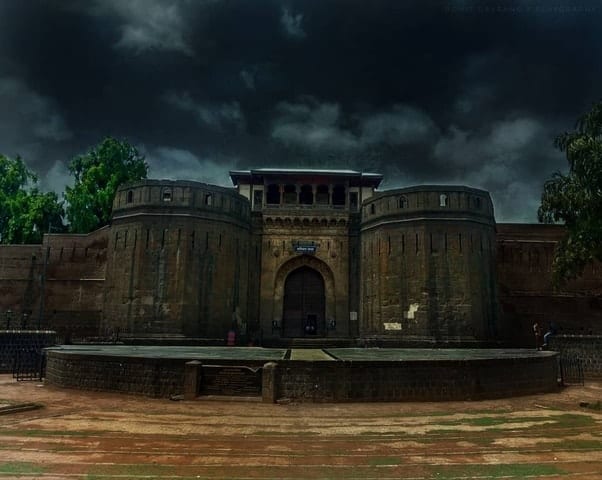
Shaniwarwada is a historical fortification in the city of Pune in Maharashtra, India. Built in 1732, it was the seat of the Peshwas of the Maratha Empire until 1818, when the Peshwas lost control to the British East India Company after the Third Anglo-Maratha War. Following the rise of the Maratha Empire, the palace became the center of Indian politics in the 18th century.The fort itself was largely destroyed in 1828 by an unexplained fire, but the surviving structures are now maintained as a tourist site.
Read More About Shaniwar Wada / Source
Rajgad Fort
Rajgad (literal meaning Ruling Fort) is a hill fort situated in the Pune district of Maharashtra, India. Formerly known as Murumdev, the fort was the capital of the Maratha Empire under the rule of Shivaji for almost 26 years, after which the capital was moved to the Raigad Fort. Treasures discovered from an adjacent fort called Torna were used to completely build and fortify the Rajgad Fort.
Read More About Rajgad Fort / Source
Malhargad

Malhargarh is a hill fort in western India, near Saswad, 30 kilometers from Pune. It is also known as Sonori Fort due to its location in Sonori village. The fort was named for Lord Malhari and was the last fort built by the Marathas in about 1775.
The Sahyadri range to the west of Pune in Velha taluka is split, and the forts Rajgad and Torna are on one branch while Forts Sinhagad, Purandar, Vajragad and Malhargad on the other. This range is known as the Bhuleshwar range which is spread along the East-West direction. The fort is believed to be built to keep watch on Dive ghat along the Pune-Saswad route. The fort was built during the period of 1757 to 1760. The fort was built by Bhivrâo Yashvant and Krishnaji Mâdhavrâo Pânsê, a Peshwa Sardar, who was the chief in charge of Tofkhana of the Peshwas. Citations of a visit of Elder Madhavrao Peshwe to the fort are available in historic documents. A palace, belonging to Panse, can be seen in the Sonori village though much of it is in ruins. The fort is in good condition. There are two temples constructed side-by-side: the smaller for Lord Khandoba, and the larger for Lord Mahadeva. From the top of this fort, the city of Jejuri and Parvati Hills can be seen.
Read More About Malhargad / Source
Chittorgarh Fort
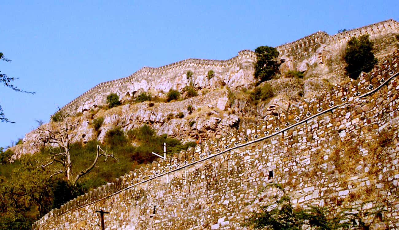
The Chittor Fort or Chittorgarh is the largest fort in India. It is a UNESCO World Heritage Site. The fort was the capital of Mewar and is located in the present-day town of Chittor. It sprawls over a hill 180 m (590.6 ft) in height spread over an area of 280 ha (691.9 acres) above the plains of the valley drained by the Berach River. The fort precinct has several historical palaces, gates, temples and two prominent commemorative towers.Beginning in the 7th century, the fort was controlled by the Mewar Kingdom. In 1303, the Turkic ruler of Delhi, Alauddin Khalji defeated Ratnasimha’s forces at the fort. In 1535 Bahadur Shah, the Sultan of Gujarat, defeated Bikramjeet Singh and took the fort. In 1567 Akbar defeated Maharana Udai Singh II’s troops. The fort’s defenders sallied forth to charge the attacking enemy but yet were not able to succeed. Following these defeats, the men committed saka, where they would ritually march to the battlefield expecting certain death; while the women are said to have committed jauhar or mass self-immolation, an example of which was led by Rani Karnavati on 8 March 1535 CE. The rulers, soldiers, noblewomen, and commoners considered death preferable to the mass rape and pillaging that was thought to occur following to surrender to the Sultanate forces.In 2013, at the 37th session of the World Heritage Committee held in Phnom Penh, Cambodia, Chittorgarh Fort, along with four other forts of Rajasthan, was declared a UNESCO World Heritage Site, as a group called the Hill Forts of Rajasthan.
Read More About Chittorgarh Fort / Source
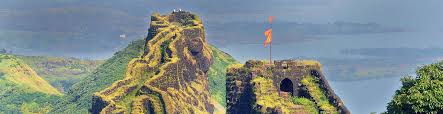
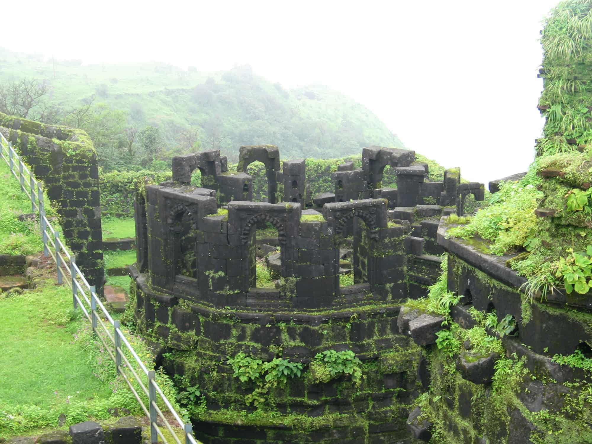
Torna Fort

Torna Fort, also known as Prachandagad, is a large fort located in Pune district, in the Indian state of Maharashtra. It is historically significant because it was the first fort captured by Chhatrapati Shivaji Maharaj in 1646, at the age of 16, forming the nucleus of the Maratha empire. The hill has an elevation of 1,403 metres (4,603 ft) above sea level, making it the highest hill-fort in the district. The name derives from Prachanda (Marathi for huge or massive) and gad (Marathi for fort).
Read More About Torna Fort / Source

Amer Fort

Amer Fort or Amber Fort is a fort located in Amer, Rajasthan, India. Amer is a town with an area of 4 square kilometres (1.5 sq mi) located 11 kilometres (6.8 mi) from Jaipur, the capital of Rajasthan. The town of Amer and the Amber Fort were originally built by the Meenas, {{|date=August 2020}} and later it was ruled by Raja Man Singh I. Located high on a hill, it is the principal tourist attraction in Jaipur. Amer Fort is known for its artistic style elements. With its large ramparts and series of gates and cobbled paths, the fort overlooks Maota Lake, which is the main source of water for the Amer Palace.
Mughal architecture greatly influenced the architectural style of several buildings of the fort. Constructed of red sandstone and marble, the attractive, opulent palace is laid out on four levels, each with a courtyard. It consists of the Diwan-e-Aam, or “Hall of Public Audience”, the Diwan-e-Khas, or “Hall of Private Audience”, the Sheesh Mahal (mirror palace), or Jai Mandir, and the Sukh Niwas where a cool climate is artificially created by winds that blow over a water cascade within the palace. Hence, the Amer Fort is also popularly known as the Amer Palace. The palace was the residence of the Rajput Maharajas and their families. At the entrance to the palace near the fort’s Ganesh Gate, there is a temple dedicated to Shila Devi, a goddess of the Chaitanya cult, which was given to Raja Man Singh when he defeated the Raja of Jessore, Bengal in 1604. (Jessore is now in Bangladesh). Raja Man Singh had 12 queens so he made 12 rooms, one for each Queen. Each room had a staircase connected to the King’s room but the Queens were not to go upstairs. Raja Jai Singh had only one queen so he built one room equal to three old queen’s rooms.
This palace, along with Jaigarh Fort, is located immediately above on the Cheel ka Teela (Hill of Eagles) of the same Aravalli range of hills. The palace and Jaigarh Fort are considered one complex, as the two are connected by a subterranean passage. This passage was meant as an escape route in times of war to enable the royal family members and others in the Amer Fort to shift to the more redoubtable Jaigarh Fort. Annual tourist visitation to the Amer Palace was reported by the Superintendent of the Department of Archaeology and Museums as 5000 visitors a day, with 1.4 million visitors during 2007. At the 37th session of the World Heritage Committee held in Phnom Penh, Cambodia, in 2013, Amer Fort, along with five other forts of Rajasthan, was declared a UNESCO World Heritage Site as part of the group Hill Forts of Rajasthan.
Read More About Amer Fort / Source
Bhujia Fort
Bhujia Fort, also spelled as Bhujiya Fort, is a fort located in the outskirts of the town of Bhuj in the district of Kutch, Gujarat, India. The fort is built atop Bhujia Hill overlooking the town. The fort was constructed for the defense of the city by Jadeja Chiefs. The construction of Bhujia fort was started by Rao Godji I (1715–1718) ruler of Kingdom of Kutch as a sort of outwork defense for Bhuj. However, the major work and completion was done during the rule of his son, Deshalji I (1718–1741). The hill was fortified as a further aid to the defense of the capital, Bhuj. Devakaran Sheth, Diwan of Kutch during Deshalji I took the lead in fortifying the hill.[2][6][7] The Fort has seen six major battles since its construction, most of which were fought in the years 1700-1800 AD between the Rajput rulers of Kutch and Muslim raiders from Sindh and the Mughal rulers of Gujarat.
Read More About Bhujia Fort / Source
Bekal Fort

Bekal Fort was built by Shivappa Nayaka of Keladi in 1650 AD, at Bekal. It is the largest fort in Kerala, spreading over 40 acres (160,000 m2). During the Perumal Age Bekal was a part of Mahodayapuram. Following the decline of Mahodayapuram Perumals, Bekal came under the sovereignty of the Mushika or Kolathiri or Chirakkal Royal Family in the 12th century. The maritime importance of Bekal increased under the Kolathiris and Malabar became an important port town.
Read More About Bekal Fort / Source
Chitradurga Fort
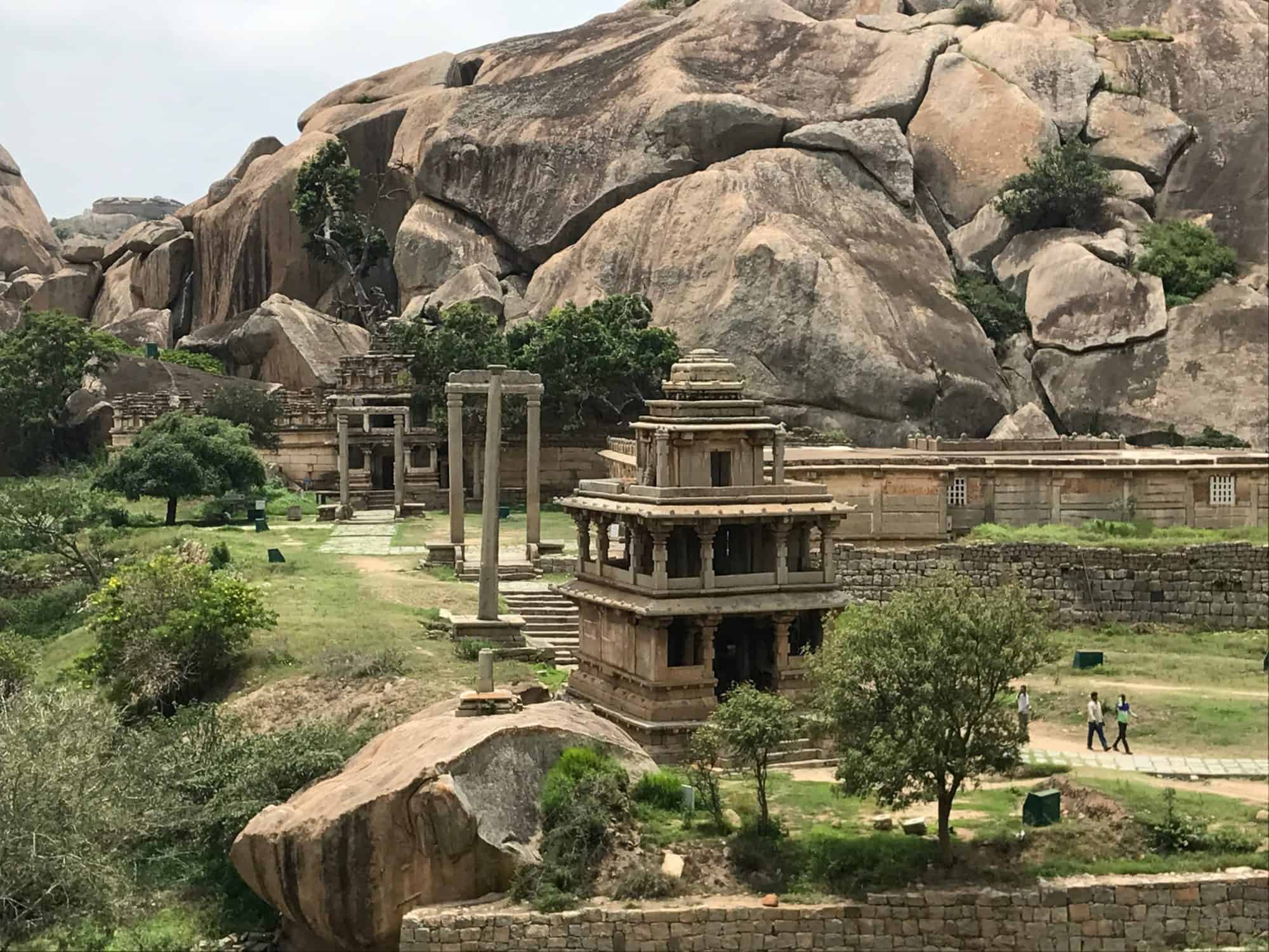
Chitradurga Fort or as the British called it Chitaldoorg, is a fortification that straddles several hills and a peak overlooking a flat valley in the Chitradurga District, Karnataka, India. The fort’s name Chitrakaldurga, which means ‘picturesque fort’ in Kannada, is the namesake of the town Chitradurga and its administrative district.The fort was built in stages between the 11th and 13th centuries by the dynastic rulers of the region including the Chalukyas and Hoysalas, later the Nayakas of Chitradurga of the Vijayanagar Empire. The Nayakas of Chitradurga, or Palegar Nayakas, were most responsible for the expansion of the fort between the 15th and 18th centuries. The fort was taken over for a short while by Hyder Ali at Chitradurga in 1779. The fort was captured by the British forces twenty years later, when they defeated his son Tipu Sultan. The fort is built in a series of seven concentric fortification walls with various passages, a citadel, masjid, warehouses for grains and oil, water reservoirs and ancient temples. There are 18 temples in the upper fort and one huge temple in the lower fort. Among these temples, the oldest and most interesting is the Hidimbeshwara temple. The masjid was an addition during Hyder Ali’s rule. The fort’s many interconnecting tanks were used to harvest rainwater, and the fort was said to never suffer from a water shortage.
Read More About Chitradurga Fort / Source
Bidar Fort

Bidar Fort is a fort situated in the Bidar, Karnataka, India. The fort, the city and the district are all affixed with the name Bidar. Sultan Alla-Ud Din Bahman of the Bahmanid Dynasty shifted his capital from Gulbarga to Bidar in 1427 and built his fort along with a number of Islamic monuments. There are over 30 monuments inside Bidar fort. Bidar city and fort are located on the edge of the Bidar plateau, the northernmost in Karnataka state. The plateau area, comprising low laterite hills, ends to the north at the Manjira River, a major tributary of the Godavari River. The Karanja River, a sub-tributary, drains the surrounding low-lying areas and feeds into the Manjiri River. Bidar district comprises the only part of the Godavari basin in Karnataka.
Read More About Bidar Fort / Source
Daulatabad Fort
Daulatabad Fort, also known as Devagiri or Deogiri, is a historical fortified citadel located in Daulatabad village near Aurangabad, Maharashtra, India. It was the capital of the Yadava dynasty (9th century–14th century CE), for a brief time the capital of the Delhi Sultanate (1327–1334), and later a secondary capital of the Ahmadnagar Sultanate (1499–1636). Around the sixth century CE, Devagiri emerged as an important uplands town near present-day Aurangabad, along caravan routes going towards western and southern India. The historical triangular fortress in the city was initially built around 1187 by the first Yadava king, Bhillama V. In 1308, the city was annexed by Sultan Alauddin Khalji of the Delhi Sultanate, which ruled over most of the Indian subcontinent. In 1327, Sultan Muhammad bin Tughluq of the Delhi Sultanate renamed the city as “Daulatabad” and shifted his imperial capital to the city from Delhi, ordering a mass migration of Delhi’s population to Daulatabad. However, Muhammad bin Tughluq reversed his decision in 1334 and the capital of the Delhi Sultanate was shifted back from Daulatabad to Delhi. In 1499, Daulatabad became a part of the Ahmadnagar Sultanate, who used it as their secondary capital. In 1610, near Daulatabad Fort, the new city of Aurangabad, then named Khadki, was established to serve as the capital of the Ahmadnagar Sultanate by the Ethiopian military leader Malik Ambar, who was brought to India as a slave but rose to become a popular Prime Minister of the Ahmadnagar Sultanate. Most of the present-day fortification at Daulatabad Fort was constructed under the Ahmadnagar Sultanate.
Read More About Daulatabad Fort / Source
Kumbhalgarh Fort
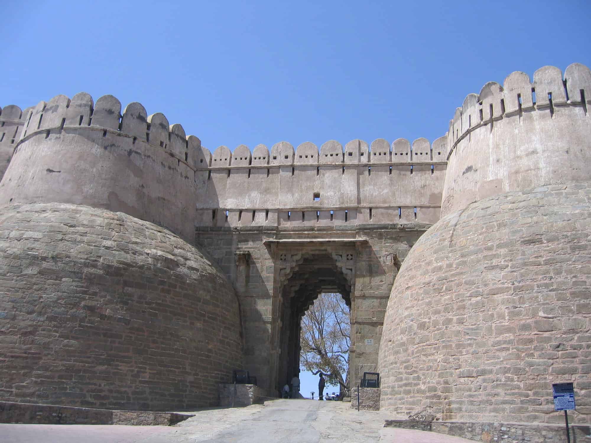
Kumbhalgarh (literally “Kumbhal fort”) is a Mewar fortress on the westerly range of Aravalli Hills, in the Rajsamand district near Udaipur of Rajasthan state in western India. It is a World Heritage Site included in Hill Forts of Rajasthan. Built during the course of the 15th century by Rana Kumbha. Occupied until the late 19th century, the fort is now open to the public and is spectacularly lit for a few minutes each evening. Kumbalgarh is situated 82 km northwest of Udaipur by road. It was the most important fort in Mewar after Chittorgarh Fort.
In 2013, at the 37th session of the World Heritage Committee held in Phnom Penh, Cambodia, Kumbhalgarh Fort, along with five other forts of Rajasthan, was declared a UNESCO World Heritage Site under the group Hill Forts of Rajasthan. The fort is among the largest fort complexes in the world, and the second largest fort in India after Chittor Fort.
Read More About Kumbhalgarh Fort / Source
Gwalior Fort

Gwalior Fort (Gwāliiyar Qila) is a hill fort near Gwalior, Madhya Pradesh, India. The fort has existed at least since the 10th century, and the inscriptions and monuments found within what is now the fort campus indicate that it may have existed as early as the beginning of the 6th century. The fort has been controlled by a number of different rulers in its history.
The present-day fort consists of a defensive structure and two main palaces, Gujari Mahal and Man Mandir, built by Man Singh Tomar (reigned 1486–1516 CE). The Gujari Mahal palace was built for Queen Mrignayani. It is now an archaeological museum. The second oldest record of “zero” in the world was found in a small temple (the stone inscription has the oldest record of the numeric zero symbol having a place value as in the modern decimal notation), which is located on the way to the top. The inscription is around 1500 years old.
Read More About Gwalior Fort / Source
Golconda Fort

The Qutb Shahi dynasty ruled the Golconda Sultanate in south India from 1518 AD to 1687 AD. The Qutb Shahis were descendants of Qara Yusuf from Qara Qoyunlu, a Turkoman Muslim tribe. After the collapse of Bahmani Sultanate, the “Qutb Shahi” dynasty was established in 1518 AD by Quli Qutb Mulk who assumed the title of “Sultan”. In 1636, Shah Jahan forced the Qutb Shahis to recognize Mughal suzerainty. The dynasty came to an end in 1687 during the reign of its seventh Sultan Abul Hasan Qutb Shah, when Mughal Emperor Aurangzeb seized Golconda fort and occupied the kingdom. The kingdom extended from the parts of modern day states of Karnataka, Andhra Pradesh and Telangana. The Golconda sultanate was constantly in conflict with the Adil Shahis and Nizam Shahis.The Qutb Shahis were great patrons of persianate Shia culture, eventually it also adopted the regional culture of the Deccan (Telugu culture, language and the newly developed Deccani dialect of Urdu). Although Telugu was not their mother tongue, the Golconda rulers spoke and wrote Telugu, and patronized Telugu so exclusively that they were termed the “Telugu Sultans”. The Qutb Shahis were known for their secular rule.
Read More About Golconda Fort / Source
Nahargarh Fort

Nahargarh Fort stands on the edge of the Aravalli Hills, overlooking the city of Jaipur in the Indian state of Rajasthan. Along with Amer Fort and Jaigarh Fort, Nahargarh once formed a strong defense ring for the city. The fort was originally named Sudarshangarh, but it became known as Nahargarh, which means ‘abode of tigers’. The popular belief is that Nahar here stands for Nahar Singh Bhomia, whose spirit haunted the place and obstructed construction of the fort. Nahar’s spirit was pacified by building a temple in his memory within the fort, which thus became known by his name.
Read More About Nahargarh Fort / Source
Murud Janjira Fort

Murud-Janjira is the local name of a famous fort and tourist place situated on an island just off the coastal city of Murud, in the Raigad district of Maharashtra, India. Murud-Janjira Fort is situated on an oval-shaped rock off the Arabian Sea coast near the port city of Murud, 165 km (103 mi) south of Mumbai. Janjira is considered one of the strongest marine forts in India. The fort is approached by sailboats from Rajapuri jetty.
Read More About Murud Janjira Fort / Source
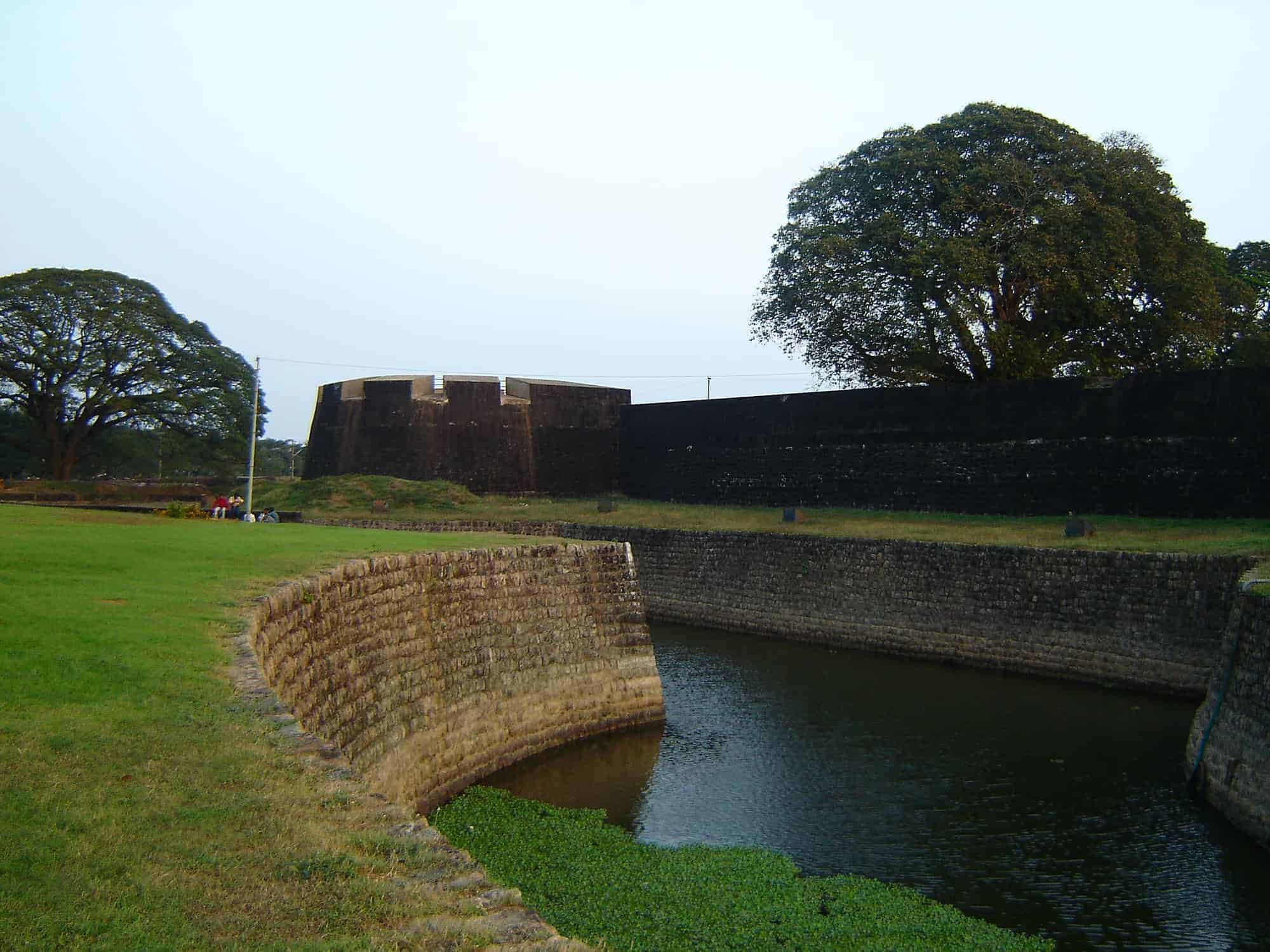
Srirangapatna Fort
Srirangapatna Fort is a historical fort located in Srirangapatna, the historical capital city in the South Indian state of Karnataka. Built by the Timmanna Nayaka in 1454. The fort was fully fortified and the architecture was modified with the help of French architects to meet the growing needs of saving against invaders. The river Kaveri surrounds the fort in one of the sides. The fort is protected in the West and Northern directions by river Cauvery. The fort had Lal Mahal and Tipu’s palace, which were demolished during the British capture of 1799. There are seven outlets and two dungeons.
Colonel Bailey’s Dungeon, Daria Daulat Bagh, Gumbaj containing tomb of Tipu Sultan, Juma Masjid (Masjid-E-Ala), Obelisk monuments and Fort walls near the breach, spot where Tipu’s Body was found, Sri Kanthirava statue in Narasimha Temple, Sri Ranganatha Svami Temple and Thomas Inman’s Dungeon are maintained as protected monuments under the Bangalore Circle of the Archaeological Survey of India.
Read More About Srirangapatna Fort / Source
Leh Palace
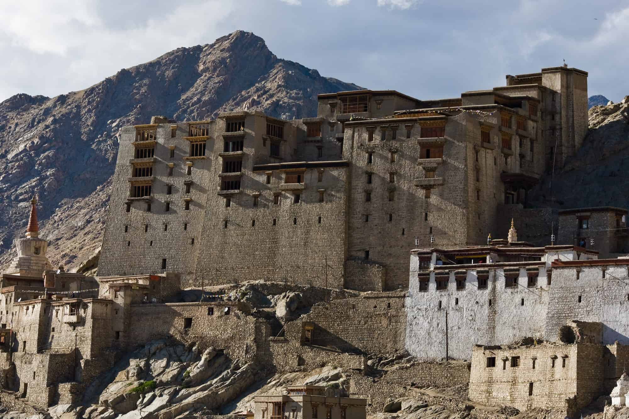
Leh Palace is a former royal palace overlooking the town of Leh, Ladakh, in the Indian Himalayas. It was constructed circa 1600 by Sengge Namgyal. The palace was abandoned when Dogra forces took control of Ladakh in the mid-19th century and forced the royal family to move to Stok Palace.It is nine storeys high; the upper floors accommodated the royal family, while the lower floors held stables and store rooms. Much of the palace is in deteriorated condition, and little survives of its interior decorations. The Palace Museum holds a rich collection of jewellery, ornaments, ceremonial dresses and crowns. Tibetan thangka or paintings, which are more than 450 years old, with intricate designs still retain the bright colours derived from crushed and powdered gems and stones. Structures around the palace’s base include the prominent Namgyal Stupa, the colourfully muralled Chandazik Gompa and the 1430 Chamba Lhakhang, with medieval mural fragments located between the inner and outer walls.
The palace is being restored by the Archaeological Survey of India.The palace is open to the public and the roof provides panoramic views of Leh and the surrounding areas.
Read More About Leh Palace / Source
Uparkot Fort
Uparkot is a fort located in east side of Junagadh, Gujarat, India. A fort and town was established at the foothills of Girnar hill during reign of the Maurya Empire and continued to be used during Gupta period, but it lost its importance when the capital of Saurashtra region was moved from Junagadh to Vallabhi by Maitraka. Chudasamas settled around Junagadh from 875 CE according to bards when they acquired Vamansthali (Vanthli) from Chavda ruler.
Read More About Uparkot Fort / Source
Jaigarh Fort
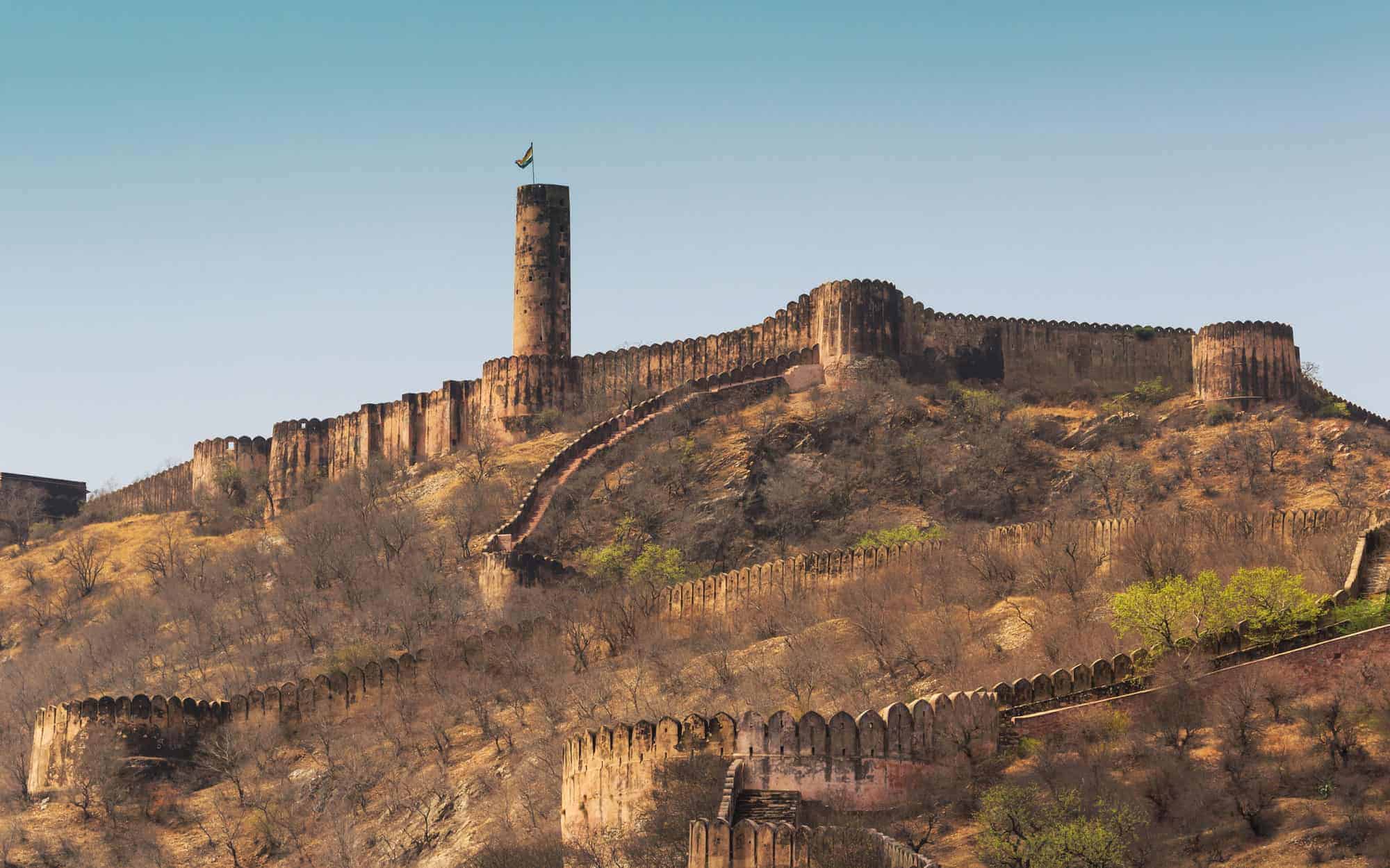
Jaigarh Fort is situated on the promontory called the Cheel ka Teela (Hill of Eagles) of the Aravalli range; it overlooks the Amer Fort and the Maota Lake, near Amer in Jaipur, Rajasthan, India. The fort was built by Jai Singh II in 1726 to protect the Amer Fort and its palace complex and was named after him.The fort, rugged and similar in structural design to the Amer Fort, is also known as Victory Fort. It has a length of 3 kilometres (1.9 mi) along the north–south direction and a width of 1 kilometre (0.62 mi). The fort features a cannon named “Jaivana”(Jaivana Cannon), which was manufactured in the fort precincts and was then the world’s largest cannon on wheels. Jaigarh Fort and Amer Fort are connected by subterranean passages and considered as one complex.
Read More About Jaigarh Fort / Source

Kangra Fort
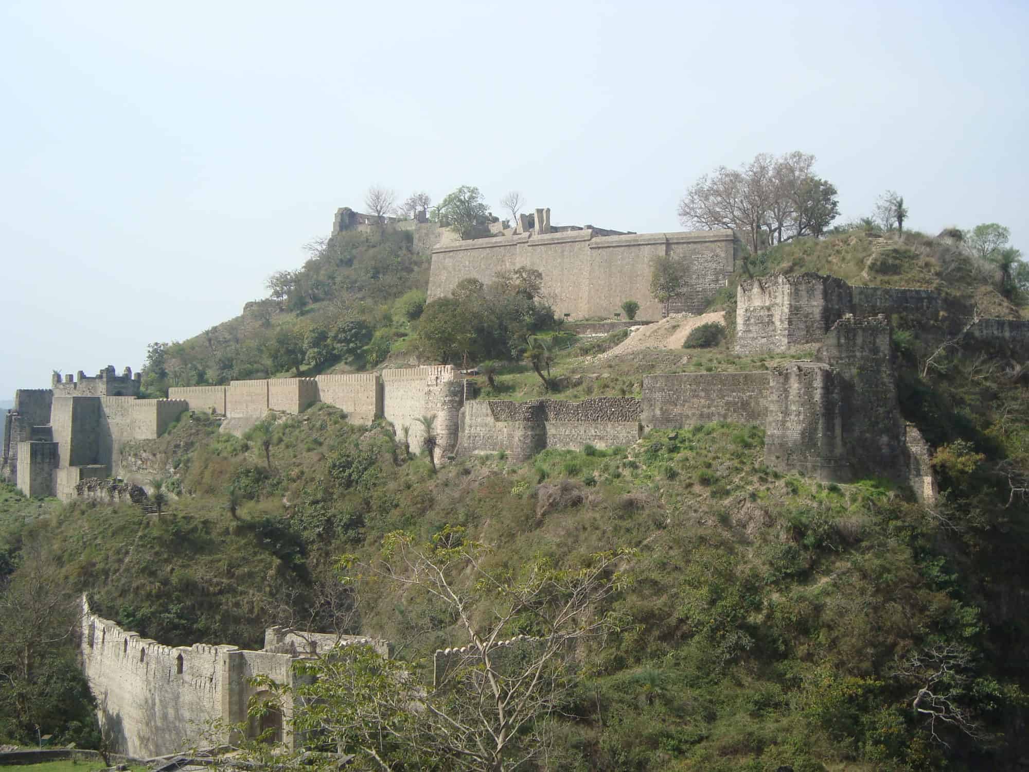
The Kangra Fort is located 20 kilometers from the town of Dharamsala on the outskirts of the town of Kangra, India. The Kangra Fort was built by the royal Rajput family of Kangra State (the Katoch dynasty), which traces its mythological origins to the ancient Trigarta Kingdom, mentioned in the Mahabharata epic.
Read More About Kangra Fort / Source
Raigad Fort
Raigad Fort is a famous fort on the hill in Mahad in Raigad district, Maharashtra. It was built by Chhatrapati Shivaji and made it his capital in 1674. This fort is located in Sahyadri mountain range. It is 820 meters (2700 ft) above sea level. He has a special identity on the Maratha Empire. Chhatrapati Shivaji Maharaj took this fort into the capital of Swarajya in the 17th century, taking into consideration the specialty and location of Raigadkila. The fort is a very powerful fort. The coronation of Chhatrapati Shivaji Maharaj also took place here.
Read More About Raigad Fort / Source

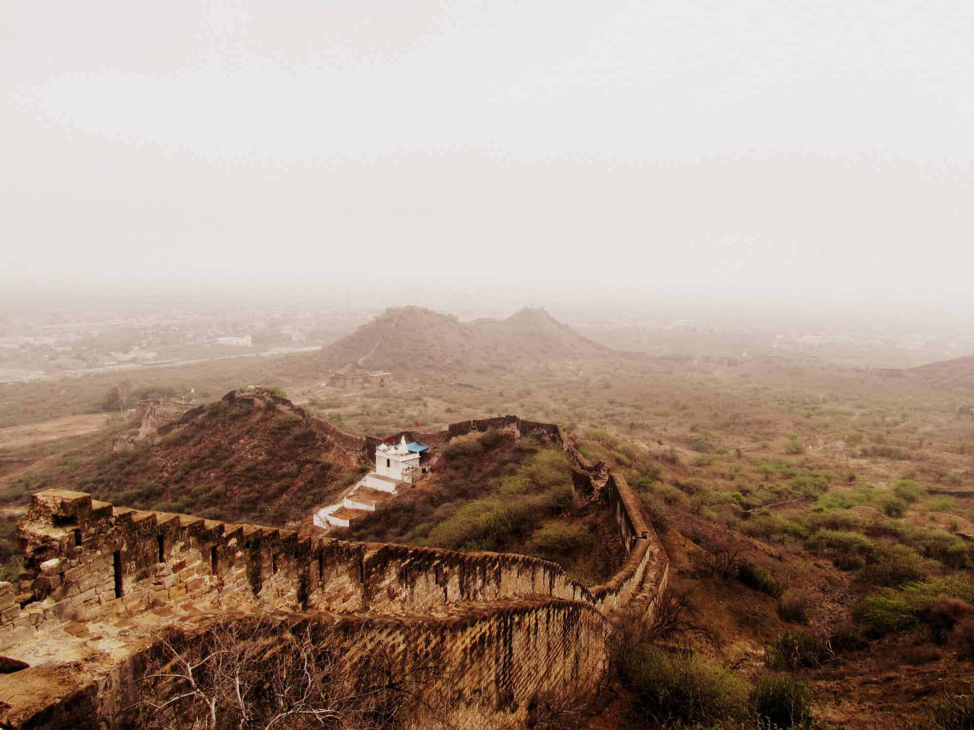
Ranthambore Fort
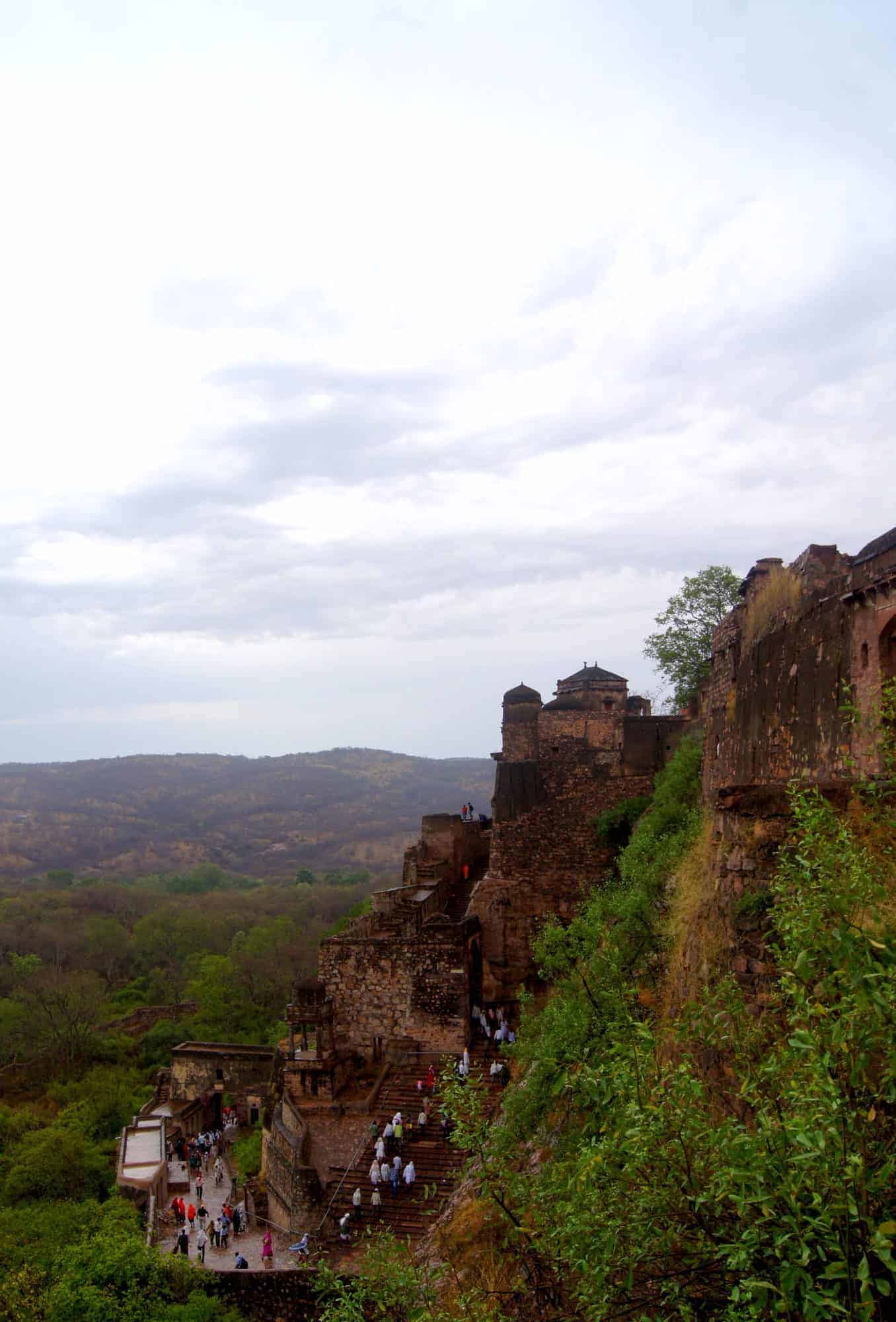
Ranthambore Fort lies within the Ranthambore National Park, near the city of Sawai Madhopur, the park being the former hunting grounds of the Maharajahs of Jaipur until the time of India’s Independence. It is a formidable fort having been a focal point of the historical developments of Rajasthan. The fort was held by the Chahamanas (Chauhans) until the 13th century, when the Delhi Sultanate captured it. In 2013, at the 37th session of the World Heritage Committee, Ranthambore Fort, along with 5 other forts of Rajasthan, was declared a UNESCO World Heritage Site under the group Hill Forts of Rajasthan.
Read More About Ranthambore Fort / Source
Jaisalmer Fort
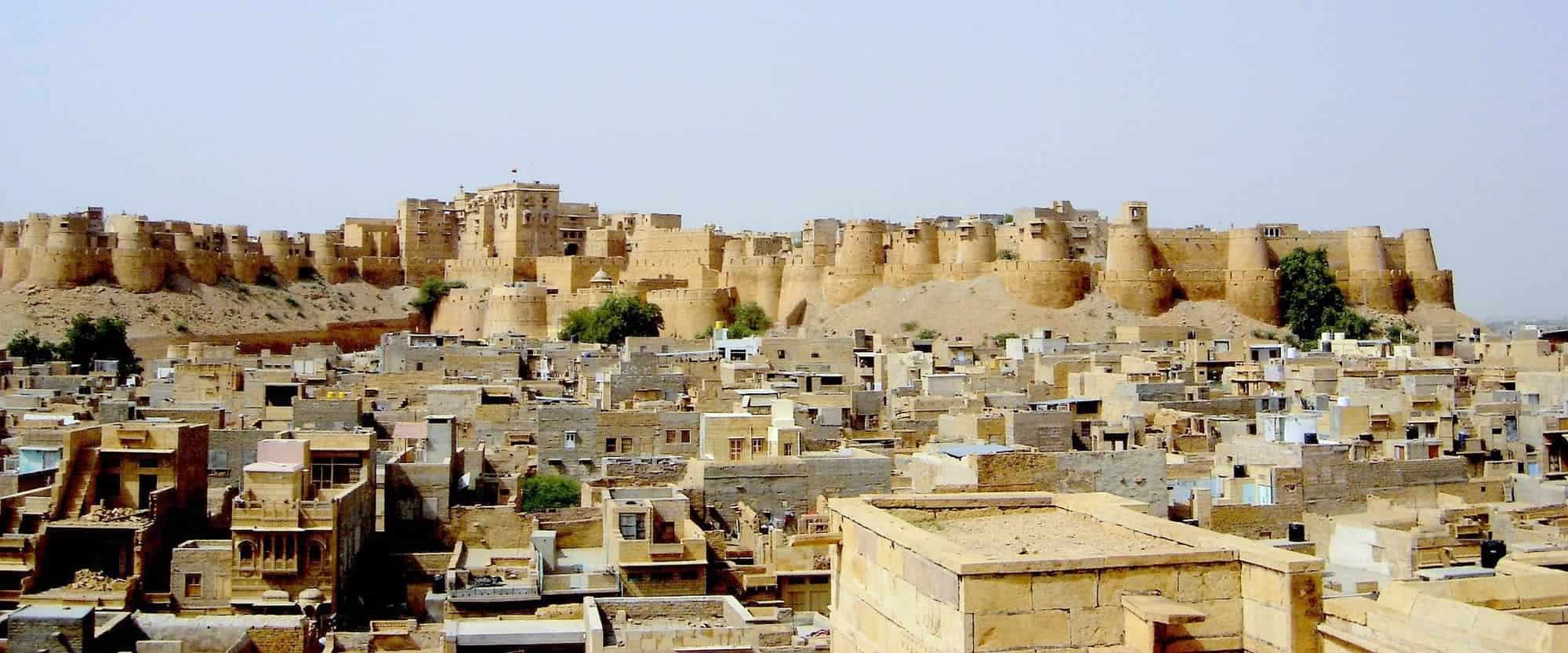
Jaisalmer Fort is situated in the city of Jaisalmer, in the Indian state of Rajasthan. It is believed to be one of the very few “living forts” in the world (such as Carcassonne, France), as nearly one fourth of the old city’s population still resides within the fort. For the better part of its 800-year history, the fort was the city of Jaisalmer. The first settlements outside the fort walls, to accommodate the growing population of Jaisalmer, are said to have come up in the 17th century.Jaisalmer Fort is the second oldest fort in Rajasthan, built in 1156 AD by the Rajput Rawal (ruler) Jaisal from whom it derives its name, and stood at the crossroads of important trade routes (including the ancient Silk road).The fort’s massive yellow sandstone walls are a tawny lion colour during the day, fading to honey-gold as the sun sets, thereby camouflaging the fort in the yellow desert. For this reason it is also known as the Sonar Quila or Golden Fort. The fort stands amidst the sandy expanse of the great Thar Desert on Trikuta Hill. It is today located along the southern edge of the city that bears its name; its dominant hilltop location making the sprawling towers of its fortifications visible for many miles around.In 2013, at the 37th session of the World Heritage Committee held in Phnom Penh, Cambodia, Jaisalmer Fort, along with 5 other forts of Rajasthan, was declared a UNESCO World Heritage Site under the group Hill Forts of Rajasthan.
Read More About Jaisalmer Fort / Source
Jhansi Fort

Jhansi Fort or Jhansi ka Kila is a fortress situated on a large hilltop called Bangira, in Uttar Pradesh, Northern India. It served as a stronghold of the Chandela Kings in Balwant Nagar from the 11th through the 17th century. The Jhansi fort is located in the middle of Jhansi city. It is 3 km from the Jhansi Railway station. The nearest airport is Gwalior, which is 103 km from Jhansi. You can also reach the fort by getting down at the Jhansi Museum Bus Stop.
Read More About Jhansi Fort / Source
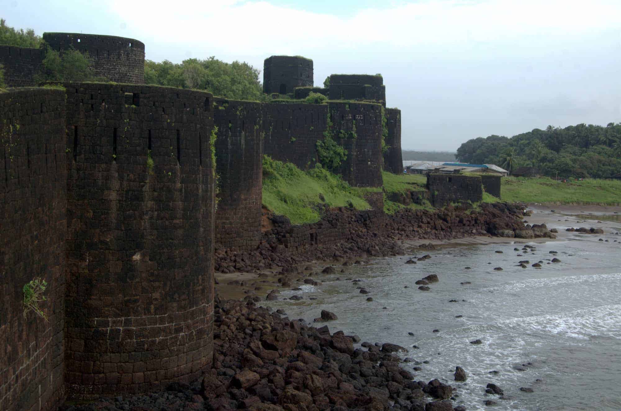
Sindhudurg Fort
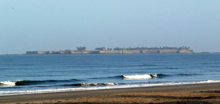
Sindhudurg Fort is a historical fort that occupies an island in the Arabian Sea, just off the coast of Maharashtra in Western India. The fort was built by Shivaji. The fortress lies on the shore of Malvan town of Sindhudurg District in the Konkan region of Maharashtra, 450 kilometres (280 mi) south of Mumbai. It is a protected monument.
Read More About Sindhudurg Fort / Source
Vijaydurg Fort
Vijaydurg (sometimes written as Viziadurg), the oldest fort on the Sindhudurg coast, was constructed during the regime of Raja Bhoja II of the Shilahar dynasty (construction period 1193-1205) and restructured by Shivaji.Earlier, the fort encompassed an area of 5 acres (1 acre = 4840 square yards or 4047 square metres) and was surrounded by sea on all four sides. Over the years the eastern trench was reclaimed and a road constructed thereon. Presently the area of fort is about 17 acres and is surrounded by the Arabian Sea on three sides. Shivaji extended the area of the fort by constructing three walls on the eastern side, each 36 metres high. He also constructed 20 bastions.According to legend, this is one of only two Maratha forts where Shivaji personally hoisted the saffron flag. The other fort is Torna.Vijaydurg Fort was called the “Eastern Gibraltar”, as it was virtually impregnable. Its locational advantages include the 40 km long Waghotan/Kharepatan creek. Large vessels cannot enter the shallow water of this creek. Also, Maratha warships could be anchored in this creek and yet remain invisible from the sea. It is a protected monument.
Read More About Vijaydurg Fort / Source
Lohagarh Fort
Lohagarh Fort (or Iron Fort) is situated at Bharatpur in Rajasthan, India. It was constructed by Bharatpur Jat rulers. Maharaja Suraj Mal built numerous forts and palaces across his kingdom, one of them being the Lohagarh Fort, one of the strongest ever built in Indian history. The inaccessible Lohagarh fort could withstand repeated attacks of British forces led by Lord Lake in 1805 when they laid siege for over six weeks.
Of the two gates in the fort, the one in the north is known as Ashtdhaatu (eight metalled) gate while the one facing the south is called Chowburja (four-pillared) gate. Monuments in the fort include are Kishori Mahal, Mahal Khas, and Kothi Khas. Moti Mahal (Bharatpur)|Moti Mahal and towers like Jawahar Burj and Fateh Burj were erected to commemorate the victory over the Mughals and the British army. The gateway has paintings of huge elephants.
Read More About Lohagarh Fort / Source
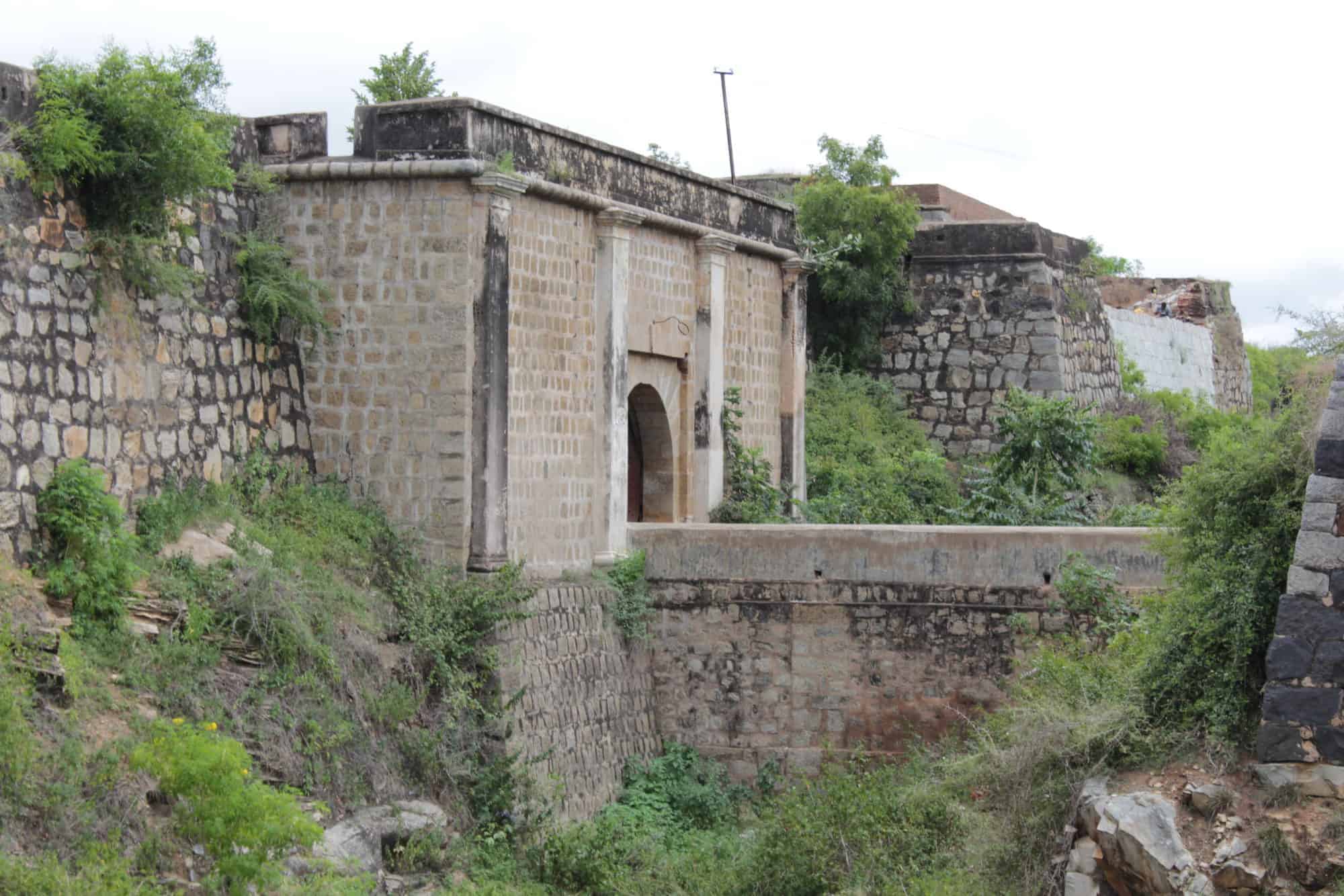
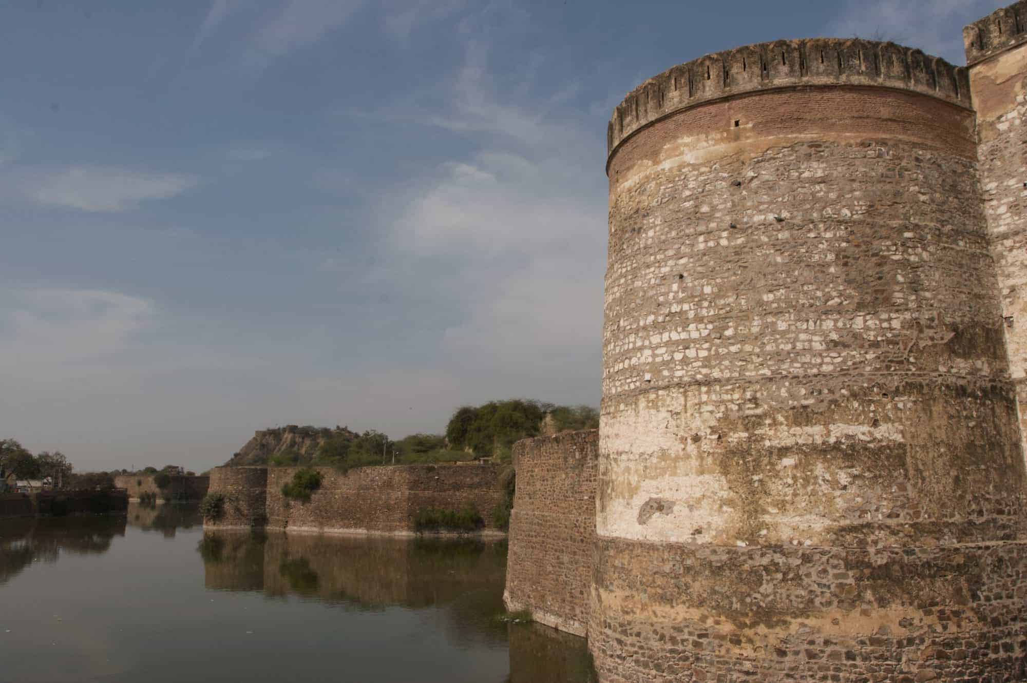
Junagarh Fort
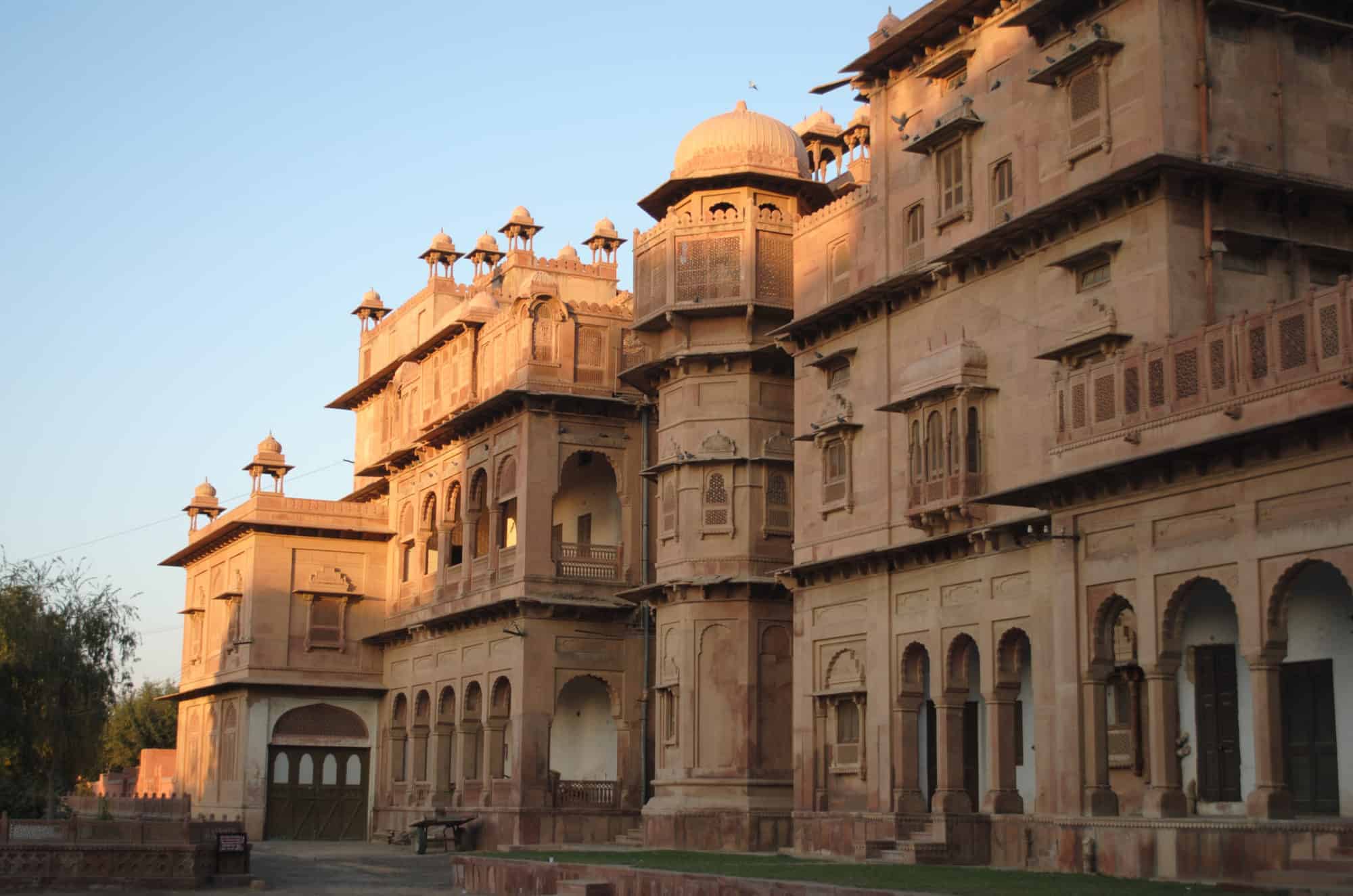
Junagarh Fort is a fort in the city of Bikaner, Rajasthan, India. The fort was originally called Chintamani and was renamed Junagarh or “Old Fort” in the early 20th century when the ruling family moved to Lalgarh Palace outside the fort limits. It is one of the few major forts in Rajasthan which is not built on a hilltop. The modern city of Bikaner has developed around the fort.The fort complex was built under the supervision of Karan Chand, the Prime Minister of Raja Rai Singh, the sixth ruler of Bikaner, who ruled from 1571 to 1611 AD. Construction of the walls and associated moat commenced in 1589 and was completed in 1594. It was built outside the original fort of the city (the first fort built by Rao Bikaji), about 1.5 kilometres (0.93 mi) from the city centre. Some remnants of the old fort are preserved near the Lakshmi Narayan temple.Historical records reveal that despite the repeated attacks by enemies to capture the fort, it was not taken, except for a lone one-day occupation by Kamran Mirza. Kamran was the second son of the Mughal Emperor Babur who attacked Bikaner in 1534, which was then ruled by Rao Jait Singh.The 5.28 hectares large fort precinct is studded with palaces, temples and pavilions. These buildings depict a composite culture, manifest in the mix of architectural styles.
Read More About Junagarh Fort / Source
Neemrana Fort

Neemrana is an ancient historical town in Alwar district of Rajasthan, India, 84 km (52 mi) from Gurgaon; 122 km (76 mi) from Delhi and 150 km (93 mi) from Jaipur on the Delhi-Jaipur highway in Neemrana tehsil. It is between Behror and Shahajahanpur. Neemrana is an industrial hub.It is the site of a 16th-century hill-fort occupied by Chauhans till 1947. The erstwhile ruling family is considered to be of the direct lineage of Prithviraj Chauhan. Some distance from Neemrana is another fort, Kesroli in Alwar district, that is one of the oldest heritage sites. Historians trace it to the Matsya Janapada of the Mahabharata times. In Kesroli one gets to see the oldest remains of Buddhist Vihara at Viratnagar where the Pandavas spent the last year of their exile incognito; Pandupole, with the only reclining statue of Hanuman; the samadhi of the ruler saint Bhartrihari. Haryanvi language and culture are followed in this area as it is just a few kilometers away from the border of Haryana and Rajasthan.
Read More About Neemrana Fort / Source
Palakkad Fort
Palakkad Fort is an old fort situated in the heart of Palakkad town of Kerala state, southern India. It was recaptured and rebuilt grandly by Sultan Hyder Ali in 1766 ACE and remains one of the best preserved forts in Kerala. The Palakkad Fort is said to have existed from very ancient times but believed to be constructed in the present form in 1766 A.D, but little is known of its early history. The local ruler, Palakkad Achchan, was originally a tributary of the Zamorin but had become independent before the beginning of the eighteenth century.
Read More About Palakkad Fort / Source
Red Fort
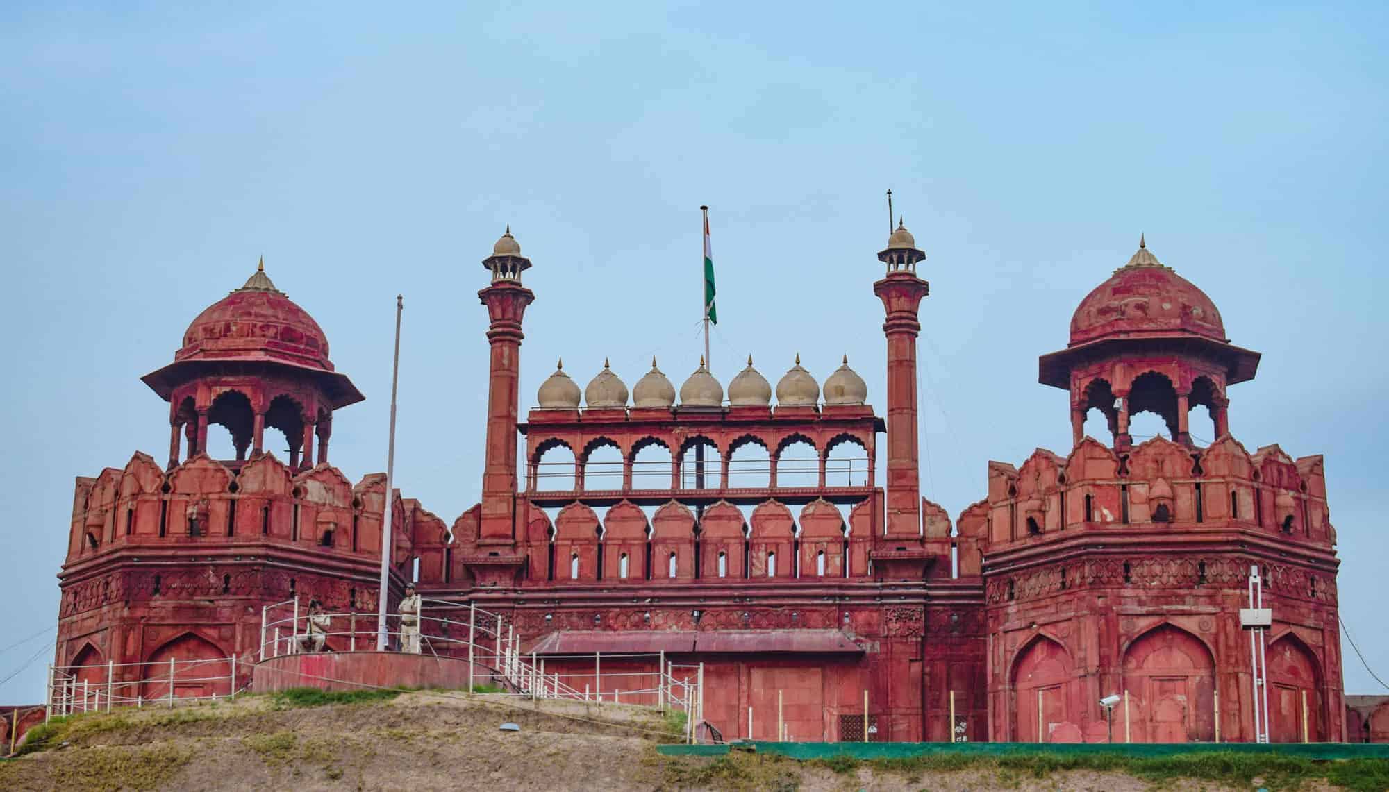
The Red Fort is a historic fort in the city of Delhi (in Old Delhi) in India that served as the main residence of the Mughal Emperors. Emperor Shah Jahan commissioned construction of the Red Fort on 12 May 1638, when he decided to shift his capital from Agra to Delhi. Originally red and white, its painting is credited to architect Ustad Ahmad Lahori, who also constructed the Taj Mahal. It was renovated between May 1639 and April 1648 based on an earlier fort. On 15 August 1947, the first prime minister of India, Jawaharlal Nehru, raised the Indian national flag above the Lahori Gate. Every year on India’s Independence Day (15 August), the prime minister hoists the Indian tricolour flag at the fort’s main gate and delivers a nationally broadcast speech from its ramparts.
Read More About Red Fort / Source
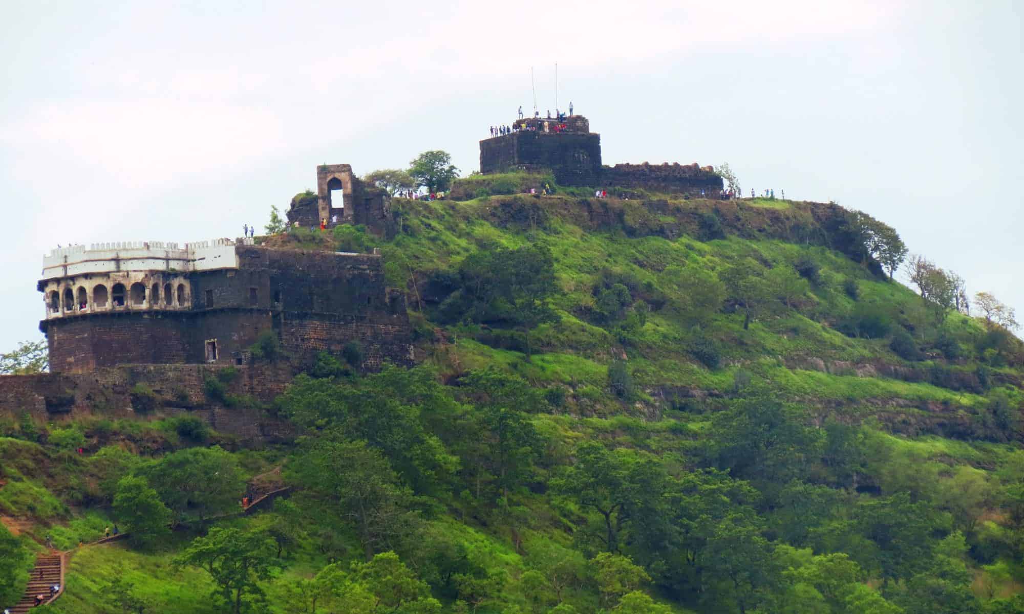
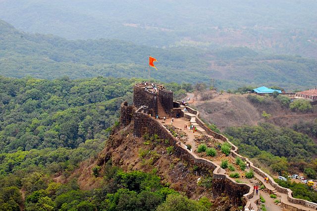
Purandar Fort

Purandar Fort is known as the birthplace of Chatrapati Sambhaji Maharaj, the son of Chatrapati Shivaji Maharaj. The fort is repeatedly mentioned in the rising of Shivaji against the Adil Shahi Bijapur Sultanate and the Mughals. The fort of Purandhar stands at 4,472 ft (1,387 m) above the sea level in the Western Ghats, 50 km to the southeast of Pune.
The twin forts of Purandar and Vajragad (or Rudramal) of which the latter is the smaller of the two, is located on the eastern side of the main fort. The village of Purandar takes its name from this fort.
Read More About Purandar Fort / Source
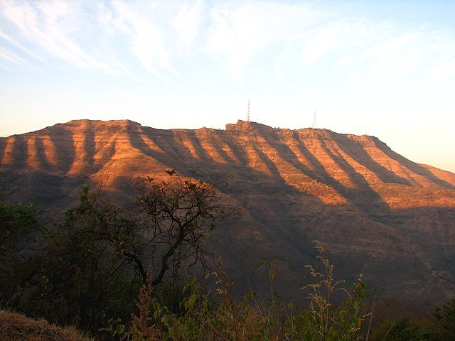
Pratapgad fort
Pratapgad (Marathi: प्रतापगड) literally ‘Valour Fort’ is a large fort located in Satara district, in the Western Indian state of Maharashtra. Significant as the site of the Battle of Pratapgad, the fort is now a popular tourist destination.
Pratapgad fort is located 15 kilometres (9.3 mi) from Poladpur and 23 kilometres (14 mi) west of Mahabaleshwar, a popular hill station in the area. The fort stands 1,080 metres (3,540 ft) above sea level and is built on a spur which overlooks the road between the villages of Par and Kinesvar.
Read More About Pratapgad fort / Source
Orchha Fort

The Orchha Fort complex, which houses a large number of ancient monuments consisting of the fort, palaces, temple, and other edifices, is located in the Orchha town in the Indian state of Madhya Pradesh. The fort and other structures within it were built by the Bundela Rajputs starting from the early 16th century by King Rudra Pratap Singh of the Orchha State and others who followed him.
The fort complex, which is accessed from an arched causeway, leads to a large gateway. This is followed by a large quadrangular open yard surrounded by palaces. These are Raja Mahal or Raja Mandir, Sheesh Mahal, Jahangir Mahal, a temple, gardens and pavilions. The battlements of the fort have ornamentation. Notable architectural features in the fort complex are projected balconies, open flat areas and decorated latticed windows.
Read More About Orchha Fort / Source
Warangal Fort
Warangal Fort is located in Warangal District, Telangana, India. It was the capital city of Kakatiyas and Musunuri Nayakas. It appears to have existed since at least the 12th century when it was the capital of the Kakatiya dynasty. The fort has four ornamental gates, known as Kakatiya Kala Thoranam, that originally formed the entrances to a now ruined great Shiva temple. The Kakatiyan arch has been adopted and officially incorporated into the emblem of Telangana after the state bifurcation. The Fort is included in the “tentative list” of UNESCO World Heritage Site. The Monument was submitted by the Permanent Delegation of India to UNESCO on 10/09/2010.
Read More About Warangal Fort / Source
Sinhagad Fort
Sinhagad is a hill fortress located at around 35 km southwest of the city of Pune, India. Some of the information available at this fort suggests that the fort could have been built 2000 years ago. The caves and the carvings in the Kaundinyeshwar temple stand as proofs for the same.
Previously known as Kondhana, the fort had been the site of many battles, most notably the Battle of Sinhagad in 1670. Perched on an isolated cliff of the Bhuleswar range in the Sahyadri Mountains, the fort is situated on a hill about 760 metres above ground and 1,312 metres above mean sea level.The Sinhagad (Lion’s Fort) was strategically built to provide natural protection due to its very steep slopes. The walls and bastions were constructed only at key places. There are two gates to enter the fort, the Kalyan Darwaza and Pune Darwaza which are positioned at the south east and north-east ends respectively. The fort was also strategically located at the centre of a string of other Maratha Empire forts such as Rajgad Fort, Purandar Fort and Torna Fort.
Read More About Sinhagad Fort / Source
Shivneri Fort

Shivneri Fort is a 17th-century military fortification located near Junnar in Pune district in Maharashtra, India. It is the birthplace of Shivaji, the founder of Maratha Empire.
Shivneri is known to be a place of Buddhist dominion from the 1st century AD. Its caves, rock-cut architecture and water system indicate the presence of habitation since 1st century AD. Shivneri got its name as it was under the possession of the Yadavas of Devagiri. This fort was mainly used to guard the old trading route from Desh to the port city of Kalyan. The place passed on to the Bahmani Sultanate after the weakening of Delhi Sultanate during the 15th century and it then passed on to the Ahmadnagar Sultanate in the 16th century. In 1595, a Maratha chief named Maloji Bhonsle, the grandfather of Shivaji Bhosale, was enabled by the Ahmadnagar Sultan, Bahadur Nizam Shah and he gave him Shivneri and Chakan. Shivaji was born at the fort on 19 February 1630 (some accounts place it 1627), and spent his childhood there. Inside the fort is a small temple dedicated to the goddess Shivai Devi, after whom Shivaji was named. The English traveller Fraze visited the fort in 1673 and found it invincible. According to his accounts, the fort was well-stocked to feed thousand families for seven years. The fort came under the control of the British Rule in 1820 after the Third Anglo-Maratha War.
Read More About Shivneri Fort / Source
Keywords:
Most Popular Forts in India Famous Indian Forts Amazing Forts in India Historical Forts in India