11 Must visit Tourist Place In India

On hearing the name of India, you get the idea of historical and cultural heritage, but there are not only cultural heritage to visit or see in this country of diversities but also a storehouse of natural beauty. Visions such as Switzerland, Iceland, and western civilizations can also be seen in the Indian subcontinent.
India is a unique country. Millions of tourists reach here every year to see the land of surprising contrasts and experience the energy of a country where the modern, ultra-modern, and traditional worlds meet. Indeed, the amazing country preserves a super-rich heritage that’s the outcome of a rich history of diverse cultures and religions leaving their indelible mark. The country offers sacred sites, sun-washed beaches, lush green national parks, wonderful mountains, thrilling wildlife sanctuaries, fascinating museums, dense forests, vast deserts, sacred rivers, and whatnot. Here’s a list of the best tourist places in India. These places reflect why India is famous for its unity in diversity and why Indian tourist places are popular all over the world. Know about the places and try to visit the places as well because the more you travel the more your horizon expands and knowledge increases.
Darjeeling

Darjeeling is a city and a municipality in the Indian state of West Bengal. It is located in the Lesser Himalayas at an elevation of 2,000 metres (6,700 ft). It is noted for its tea industry, its views of Kangchenjunga, the world’s third-highest mountain, and the Darjeeling Himalayan Railway, a UNESCO World Heritage Site. Darjeeling is the headquarters of the Darjeeling district which has a partially autonomous status called Gorkhaland Territorial Administration within the state of West Bengal. It is also a popular tourist destination in India.
The recorded history of the town starts from the early 19th century when the colonial administration under the British Raj set up a sanatorium and a military depot in the region. Subsequently, extensive tea plantations were established in the region and tea growers developed hybrids of black tea and created new fermentation techniques. The resultant distinctive Darjeeling tea is internationally recognised and ranks among the most popular black teas in the world. The Darjeeling Himalayan Railway connects the town with the plains and has some of the few steam locomotives still in service in India.
Darjeeling has several British-style private schools, which attract pupils from all over India and a few neighbouring countries. The varied culture of the town reflects its diverse demographic milieu comprising Lepcha, Khampa, Gorkha, Newar, Sherpa, Bhutia, Bengali and other mainland Indian ethno-linguistic groups. Darjeeling, alongside its neighbouring town of Kalimpong, was the centre of the Gorkhaland social movement in the 1980s and summer 2017.
Read More About Darjeeling / Source
Ooty
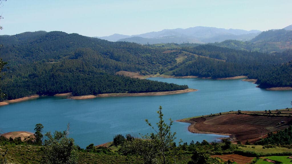
Ooty, officially known as Udagamandalam (also known as Ootacamund ; abbreviated as Udhagai), is a town and a municipality in the Nilgiris district of the Indian state of Tamil Nadu. It is located 86 km north of Coimbatore and 128 km south of Mysore and is the headquarters of the Nilgiris district. It is a popular hill station located in the Nilgiri Hills. Local residents call it Queen of Hills.
Originally occupied by the Toda people, the area came under the rule of the East India Company at the end of the 18th century. The economy is based on tourism and agriculture, along with the manufacture of medicines and photographic film. The town is connected by the Nilgiri ghat roads and Nilgiri Mountain Railway. Its natural environment attracts tourists and it is a popular summer destination. In 2011, the town had a population of 88,430.
Goa

Goa is a state on the southwestern coast of India within the region known as the Konkan, and geographically separated from the Deccan highlands by the Western Ghats. It is surrounded by the Indian states of Maharashtra to the north and Karnataka to the east and south, with the Arabian Sea forming its western coast. It is India’s smallest state by area and the fourth-smallest by population. Goa has the highest GDP per capita among all Indian states, two and a half times that of the country. It was ranked the best-placed state by the Eleventh Finance Commission for its infrastructure and ranked on top for the best quality of life in India by the National Commission on Population based on the 12 Indicators.Panaji is the state’s capital, while Vasco da Gama is its largest city. The historic city of Margao still exhibits the cultural influence of the Portuguese, who first landed in the early 16th century as merchants and conquered it soon thereafter. Goa was a former state of the Portuguese Empire. The Portuguese overseas territory of Portuguese India existed for about 450 years until it was annexed by India in 1961. Its majority and official language is Konkani.
Goa is visited by large numbers of international and domestic tourists each year for its white sand beaches, nightlife, places of worship and World Heritage-listed architecture. It has rich flora and fauna, owing to its location on the Western Ghats range, a biodiversity hotspot.
Nainital
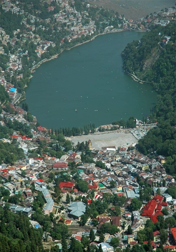
Nainital is a popular hill station in the Indian state of Uttarakhand. It is the judicial capital of Uttarakhand, the High Court of the state being located there, and is the headquarters of the Kumaon division as well as an eponymous district. It also houses the Governor of Uttarakhand, who resides in the Raj Bhavan. Nainital was the summer capital of the United Provinces.
Nainital is located in the Kumaon foothills of the outer Himalayas at a distance of 285 km (177 mi) from the state capital Dehradun and 345 km (214 mi) from New Delhi, the capital of India. Situated at an altitude of 1,938 metres (6,358 ft) above sea level, the city is set in a valley containing an eye-shaped lake, approximately two miles in circumference, and surrounded by mountains, of which the highest are Naina Peak (2,615 m (8,579 ft)) on the north, Deopatha (2,438 m (7,999 ft)) on the west, and Ayarpatha (2,278 m (7,474 ft)) on the south. From the tops of the higher peaks, “magnificent views can be obtained of the vast plain to the south, or of the mass of tangled ridges lying north, bound by the great snowy range which forms the central axis of the Himalayas.” The hill station attracts tourists round the year.
Read More About Nainital / Source
Kullu
Kullu is a municipal council town that serves as the administrative headquarters of the Kullu district of the Indian state of Himachal Pradesh. It is located on the banks of the Beas River in the Kullu Valley about 10 kilometres (6.2 mi) north of the airport at Bhuntar.
Kullu Valley is a broad open valley formed by the Beas River between Manali and Largi. This valley is known for its temples and its hills covered with pine and deodar forest and sprawling apple orchards. The course of the Beas river presents a succession of magnificent, clad with forests of deodar, towering above trees of pine on the lower rocky ridges. Kullu valley is sandwiched between the Pir Panjal, Lower Himalayan and Great Himalayan Ranges.
Read More About Kullu / Source

Manali, Himachal
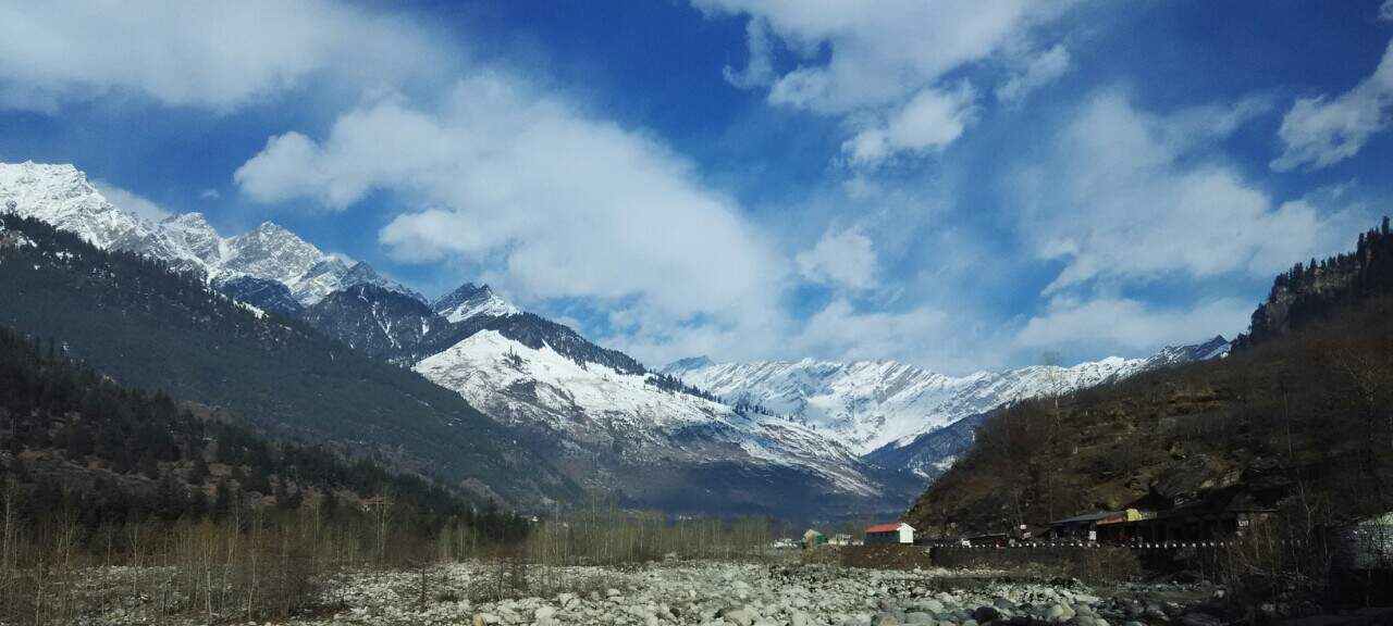
Manali is a resort town nestled in the mountains of the Indian state of Himachal Pradesh near the northern end of the Kullu Valley in the Beas River Valley. It is located in the Kullu district, about 270 km (168 mi) north of the state capital, Shimla, 309 km (192 miles) north east of Chandigarh and 544 km (338 miles) northeast of Delhi, the national capital. The small town, with a population of 8,096, is the beginning of an ancient trade route to Ladakh and from there over the Karakoram Pass on to Yarkand and Khotan in the Tarim Basin. It is a popular tourist destination and serves as the gateway to Lahaul and Spiti district as well as Leh.
Read More About Manali, Himachal / Source
Ladakh
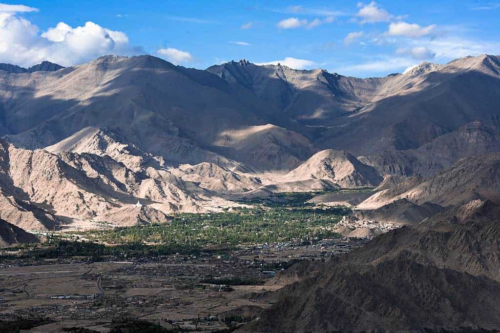
Ladakh is a region administered by India as a union territory, and constituting a part of the larger Kashmir region, which has been the subject of dispute between India, Pakistan, and China since 1947. It is bordered by the Tibet Autonomous Region to the east, the Indian state of Himachal Pradesh to the south, both the Indian union territory of Jammu and Kashmir and the Pakistan-administered Gilgit-Baltistan to the west, and the southwest corner of Xinjiang across the Karakoram Pass in the far north. It extends from the Siachen Glacier in the Karakoram range to the north to the main Great Himalayas to the south. The eastern end, consisting of the uninhabited Aksai Chin plains, is claimed by the Indian Government as part of Ladakh, and has been under Chinese control since 1962. Until 2019, Ladakh was a region of the state of Jammu and Kashmir. In August 2019, the Parliament of India passed an act by which Ladakh became a union territory on 31 October 2019.In the past Ladakh gained importance from its strategic location at the crossroads of important trade routes, but since the Chinese authorities closed the borders between Tibet Autonomous Region and Ladakh in the 1960s, international trade has dwindled except for tourism. Since 1974, the Government of India has successfully encouraged tourism in Ladakh. Since Ladakh is a part of the strategically important Kashmir region, the Indian military maintains a strong presence in the region.
The largest town in Ladakh is Leh, followed by Kargil, each of which headquarters a district. The Leh district contains the Indus, Shyok and Nubra river valleys. The Kargil district contains the Suru, Dras and Zanskar river valleys. The main populated regions are the river valleys, but the mountain slopes also support the pastoral Changpa nomads. In contrast to the neighbouring Jammu and Kashmir, Ladakh has a non-Muslim majority. The main religious groups in the region are Muslims (mainly Shia) (46%), Tibetan Buddhists (40%), Hindus (12%) and others (2%). Ladakh is one of the most sparsely populated regions in India. As its culture and history are closely related to that of Tibet, it is known as the “Little Tibet”.Ladakh is the largest and the second least populous union territory of India.
Read More About Ladakh / Source
Jaipur
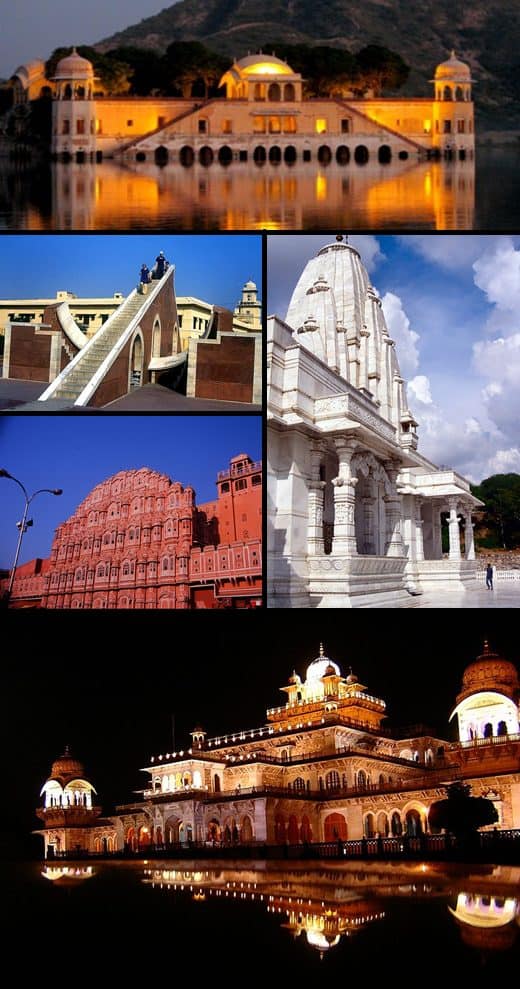
Jaipur is the capital and the largest city of the Indian state of Rajasthan. As of 2011, the city had a population of 3.1 million, making it the tenth most populous city in the country. Jaipur is also known as the Pink City, due to the dominant color scheme of its buildings. It is located 268 km (167 miles) from the national capital New Delhi.
Jaipur was founded in 1727 by the Rajput ruler Jai Singh II, the ruler of Amer, after whom the city is named. It was one of the earliest planned cities of modern India, designed by Vidyadhar Bhattacharya. During the British Colonial period, the city served as the capital of Jaipur State. After independence in 1947, Jaipur was made the capital of the newly formed state of Rajasthan.
Jaipur is a popular tourist destination in India and forms a part of the west Golden Triangle tourist circuit along with Delhi and Agra (240 km, 149 mi). It also serves as a gateway to other tourist destinations in Rajasthan such as Jodhpur (348 km, 216 mi), Jaisalmer (571 km, 355 mi), Udaipur (421 km, 262 mi), Kota (252 km, 156 mi)
and Mount Abu
(520 km, 323 mi). Jaipur is located 616 km from Shimla.
On 6 July 2019, UNESCO World Heritage Committee inscribed Jaipur the ‘Pink City of India’ among its World Heritage Sites. The city is also home to the UNESCO World Heritage Sites Amber Fort and Jantar Mantar.
Read More About Jaipur / Source
Mumbai
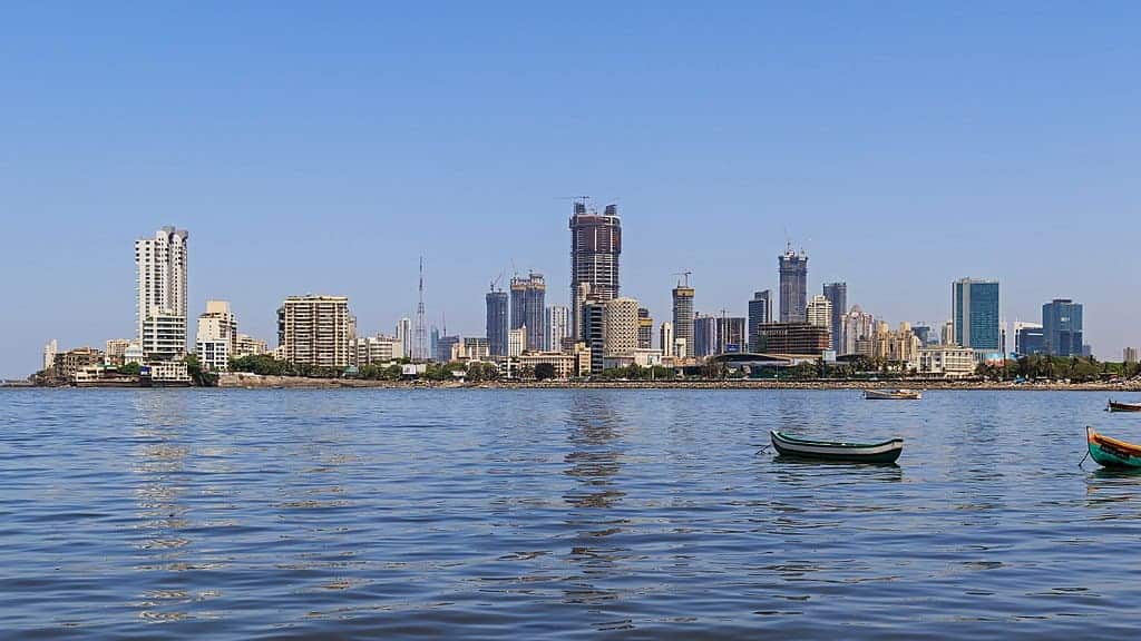
Mumbai (formerly known as Bombay, the official name until 1995) is the capital city of the Indian state of Maharashtra. According to the United Nations, as of 2018, Mumbai is the second-most populous city in the country after Delhi and the seventh-most populous city in the world with a population of roughly 20 million. As per Indian government population census of 2011, Mumbai was the most populous city in India with an estimated city proper population of 12.5 million living under Municipal Corporation of Greater Mumbai. Mumbai is the centre of the Mumbai Metropolitan Region, the sixth most populous metropolitan area in the world with a population of over 23 million. Mumbai lies on the Konkan coast on the west coast of India and has a deep natural harbour. In 2008, Mumbai was named an alpha world city. It has the highest number of millionaires and billionaires among all cities in India. Mumbai is home to three UNESCO World Heritage Sites: the Elephanta Caves, Chhatrapati Shivaji Maharaj Terminus, and the city’s distinctive ensemble of Victorian and Art Deco buildings.The seven islands that constitute Mumbai were originally home to communities of Marathi language speaking Koli people. For centuries, the islands were under the control of successive indigenous empires before being ceded to the Portuguese Empire and subsequently to the East India Company when in 1661 Charles II of England married Catherine of Braganza and as part of her dowry Charles received the ports of Tangier and Seven Islands of Bombay. During the mid-18th century, Bombay was reshaped by the Hornby Vellard project, which undertook reclamation of the area between the seven islands from the sea. Along with construction of major roads and railways, the reclamation project, completed in 1845, transformed Bombay into a major seaport on the Arabian Sea. Bombay in the 19th century was characterised by economic and educational development. During the early 20th century it became a strong base for the Indian independence movement. Upon India’s independence in 1947 the city was incorporated into Bombay State. In 1960, following the Samyukta Maharashtra Movement, a new state of Maharashtra was created with Bombay as the capital.Mumbai is the financial, commercial, and the entertainment capital of India. It is also one of the world’s top ten centres of commerce in terms of global financial flow, generating 6.16% of India’s GDP, and accounting for 25% of industrial output, 70% of maritime trade in India (Mumbai Port Trust and JNPT), and 70% of capital transactions to India’s economy. Mumbai has the eighth-highest number of billionaires of any city in the world, and Mumbai’s billionaires had the highest average wealth of any city in the world in 2008. The city houses important financial institutions and the corporate headquarters of numerous Indian companies and multinational corporations. It is also home to some of India’s premier scientific and nuclear institutes. The city is also home to Bollywood and Marathi cinema industries. Mumbai’s business opportunities attract migrants from all over India.
Read More About Mumbai / Source
Gulmarg
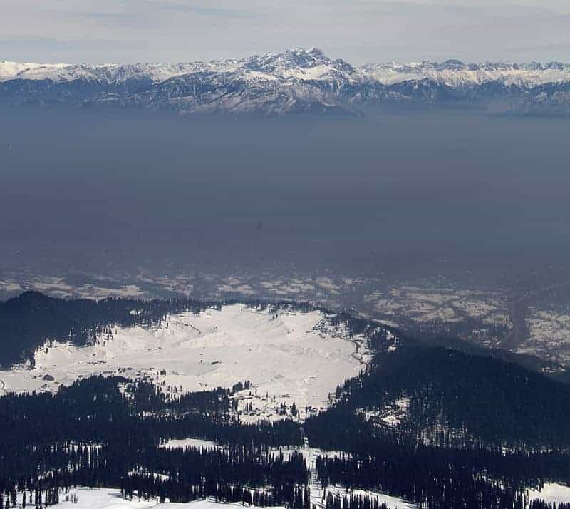
Gulmarg is a town, a hill station, a popular skiing destination and a notified area committee in the Baramulla district of Jammu and Kashmir, India. The town is situated in the Pir Panjal Range in the Western Himalayas and lies within the boundaries of Gulmarg Wildlife Sanctuary. Originally called Gauri Marg (meaning “the path of Devi Gauri”), in the 1500s it was changed to ‘Gulmarg’ by Yousuf Shah of the Chak dynasty.
Read More About Gulmarg / Source
Agra
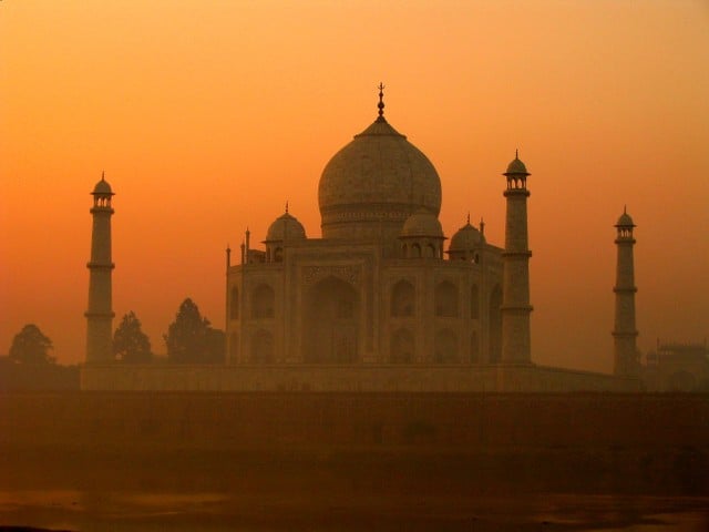
Agra is a city on the banks of the Yamuna river in the Agra district of the Indian state of Uttar Pradesh. It is 206 kilometres (128 mi) south of the national capital New Delhi. Agra is the fourth-most populous city in Uttar Pradesh and 24th in India.Sikandar Lodi was the first ruler of the Delhi Sultanate to move his capital from Delhi to Agra in 1504, and so he is regarded as being the founder of Agra. Sikandar Lodi’s son, Ibrahim Lodi, was defeated at the Battle of Panipat in 1526 by Babur, which marked the beginning of Mughal Empire. In a brief interruption in Mughal rule between 1540 and 1556, Sher Shah Suri, established the short lived Sur Empire. Agra was the capital of the Mughal Empire from 1556 to 1648, under the Mughal Emperors Akbar, Jahangir and Shah Jahan, after which Shah Jahan shifted the capital to Delhi. The Mughal Empire saw the building of many monuments, especially Taj Mahal. The city was later taken by the Jats and then Marathas and later still fell to the British Raj.
Agra is a major tourist destination because of its many Mughal-era buildings, most notably the Taj Mahal, Agra Fort and Fatehpur Sikri, all of which are UNESCO World Heritage Sites. Agra is included on the Golden Triangle tourist circuit, along with Delhi and Jaipur; and the Uttar Pradesh Heritage Arc, a tourist circuit of Uttar Pradesh, along with Lucknow and Varanasi. Agra is in the Braj cultural region.

Keywords:
Best Tourist Places In India Famous Tourist Places In India Top Tourist Spots in India Beautiful Tourist Places In India