List of 38 Heritage Sites in America

The United States is home to a vast array of cultural and natural heritage sites that are of great significance to the country’s history, identity, and landscape. These heritage sites are recognized for their outstanding universal value and are protected by federal and state laws to ensure their preservation for future generations. The list of heritage sites in the USA includes a diverse range of places, from historic landmarks and buildings to natural landscapes and ecosystems. These sites offer visitors a unique opportunity to explore the nation’s rich cultural and natural heritage and gain a deeper understanding of its history and identity. The list of heritage sites in the USA is constantly evolving, as new sites are discovered and recognized for their significance, and existing sites are updated and expanded to reflect new research and understanding. Each site on the list has its own unique story to tell, and together they provide a rich tapestry of the nation’s heritage and identity.
Independence Hall
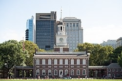
Independence Hall is a historic civic building in Philadelphia, where both the United States Declaration of Independence and the United States Constitution were debated and adopted by America’s Founding Fathers. The structure forms the centerpiece of the Independence National Historical Park. Independence Hall was named to the National Register of Historic Places in 1966 and as a World Heritage Site in 1979.The building was completed in 1753 as the Pennsylvania State House. It served as the first capital of both the United States and of the Province and later the Commonwealth of Pennsylvania. It was the principal meeting place of the Second Continental Congress from 1775 to 1781, and was the site of the Constitutional Convention, at which the U.S. Constitution, the longest-standing written and codified national constitution in the world, was ratified on June 21, 1788.A convention held in Independence Hall in 1915, presided over by former U.S. president William Howard Taft, marked the formal announcement of the formation of the League to Enforce Peace, which led to the League of Nations in 1920 and the United Nations, a quarter century later.
Read More About Independence Hall / Source
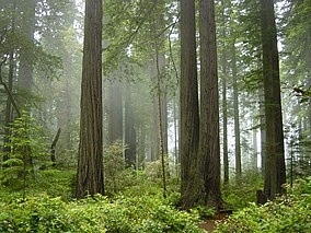
Great Smoky Mountains National Park
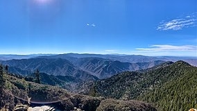
Great Smoky Mountains National Park is an American national park in the southeastern United States, with parts in North Carolina and Tennessee. The park straddles the ridgeline of the Great Smoky Mountains, part of the Blue Ridge Mountains, which are a division of the larger Appalachian Mountain chain. The park contains some of the highest mountains in eastern North America, including Clingmans Dome, Mount Guyot, and Mount Le Conte. The border between the two states runs northeast to southwest through the center of the park. The Appalachian Trail passes through the center of the park on its route from Georgia to Maine. With 14.1 million visitors in 2021, the Great Smoky Mountains National Park is the most visited national park in the United States.
The park encompasses 522,419 acres (816.28 sq mi; 211,415.47 ha; 2,114.15 km2), making it one of the largest protected areas in the eastern United States. The main park entrances are located along U.S. Highway 441 (Newfound Gap Road) in the towns of Gatlinburg, Tennessee and Cherokee, North Carolina, and also in Townsend, Tennessee. The park is internationally recognized for its mountains, waterfalls, biodiversity, and forests. In addition, the park also preserves multiple historical structures that were part of communities occupied by early European-American settlers of the area.The park was chartered by the United States Congress in 1934, and officially dedicated by President Franklin D. Roosevelt in 1940. The Great Smoky Mountains was the first national park having land and other costs paid in part with federal funds; previous parks were funded wholly with state money or private funds. The park was designated as a UNESCO World Heritage Site in 1983, and an International Biosphere Reserve in 1988.As the most visited national park in the United States, the Great Smoky Mountains National Park anchors a large tourism industry based in Sevier County, Tennessee adjacent to the park. Major attractions include Dollywood, the second-most visited tourist attraction in Tennessee, Ober Gatlinburg, and Ripley’s Aquarium of the Smokies. Tourism to the park contributes an estimated $2.5 billion annually into the local economy.
Read More About Great Smoky Mountains National Park / Source
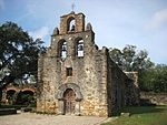
La Fortaleza and San Juan
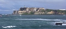
La Fortaleza and San Juan National Historic Site in Puerto Rico is a World Heritage Site located in and near San Juan, Puerto Rico. It comprises a series of fortifications across two properties:
La Fortaleza
San Juan National Historic Site
Castillo de San Felipe del Morro
Castillo de San Cristóbal
El Cañuelo
San Juan City WallsThese structures were built between the 15th and 19th centuries to defend the city and harbor of San Juan and are examples of European military architecture adapted to port cities on the American continent. La Fortaleza was the first defensive fortification built for the city. The historic site also includes Castillo de San Felipe del Morro, Castillo de San Cristóbal, El Cañuelo, and three-fourths of the old city wall.
Read More About La Fortaleza and San Juan / Source
The 20th-Century Architecture of Frank Lloyd Wright
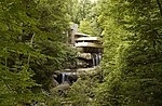
The 20th-Century Architecture of Frank Lloyd Wright is a UNESCO World Heritage Site consisting of a selection of eight buildings across the United States that were designed by American architect Frank Lloyd Wright. These sites demonstrate his philosophy of organic architecture, designing structures that were in harmony with humanity and its environment. Wright’s work had an international influence on the development of architecture in the 20th century.
Read More About The 20th-Century Architecture of Frank Lloyd Wright / Source
Petrified Forest National Park
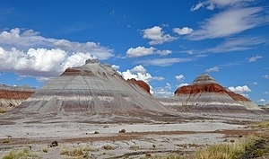
Petrified Forest National Park is an American national park in Navajo and Apache counties in northeastern Arizona. Named for its large deposits of petrified wood, the park covers about 346 square miles (900 square kilometers), encompassing semi-desert shrub steppe as well as highly eroded and colorful badlands. The park’s headquarters is about 26 miles (42 km) east of Holbrook along Interstate 40 (I-40), which parallels the BNSF Railway’s Southern Transcon, the Puerco River, and historic U.S. Route 66, all crossing the park roughly east–west. The site, the northern part of which extends into the Painted Desert, was declared a national monument in 1906 and a national park in 1962. The park received 644,922 recreational visitors in 2018.
Averaging about 5,400 feet (1,600 m) in elevation, the park has a dry windy climate with temperatures that vary from summer highs of about 100 °F (38 °C) to winter lows well below freezing. More than 400 species of plants, dominated by grasses such as bunchgrass, blue grama, and sacaton, are found in the park. Fauna include larger animals such as pronghorns, coyotes, and bobcats, many smaller animals, such as deer mice, snakes, lizards, seven kinds of amphibians, and more than 200 species of birds, some of which are permanent residents and many of which are migratory. About one third of the park is designated wilderness—50,260 acres (79 sq mi; 203 km2).The Petrified Forest is known for its fossils, especially fallen trees that lived in the Late Triassic Epoch, about 225 million years ago. The sediments containing the fossil logs are part of the widespread and colorful Chinle Formation, from which the Painted Desert gets its name. Beginning about 60 million years ago, the Colorado Plateau, of which the park is part, was pushed upward by tectonic forces and exposed to increased erosion. All of the park’s rock layers above the Chinle, except geologically recent ones found in parts of the park, have been removed by wind and water. In addition to petrified logs, fossils found in the park have included Late Triassic ferns, cycads, ginkgoes, and many other plants as well as fauna including giant reptiles called phytosaurs, large amphibians, and early dinosaurs. Paleontologists have been unearthing and studying the park’s fossils since the early 20th century.
The park’s earliest human inhabitants arrived 13,000 years ago. These Clovis-era people are the ancestors of Native Americans. By about 2,500 years ago Ancestral Pueblo farmers were growing corn and living in subterranean pit houses in what would become the park. By one-thousand years ago Ancestral Pueblo farmers lived in above-ground, masonry dwellings called pueblos and gathered in large communal buildings called great kivas. By AD 1450 Ancestral Pueblo farmers in the Petrified Forest migrated to join rapidly growing communities on the Hopi Mesas to the northwest and the Pueblo of Zuni to the east–these locations are still home to thousands of descendant community members today. More than 1000 archeological sites, including petroglyphs, have been discovered in the park. These ancestral places remain important to descendant communities. In the 16th century, Spanish explorers visited the area, and by the mid-19th century a U.S. team had surveyed an east–west route through the area where the park is now located and noted the petrified wood. Later, roads and a railway followed similar routes and gave rise to tourism and, before the park was protected, to large-scale removal of fossils. Theft of petrified wood remains a problem in the 21st century.
Read More About Petrified Forest National Park / Source

Mesa Verde National Park
Mesa Verde National Park is an American national park and UNESCO World Heritage Site located in Montezuma County, Colorado. The park protects some of the best-preserved Ancestral Puebloan archaeological sites in the United States.
Established by Congress and President Theodore Roosevelt in 1906, the park occupies 52,485 acres (21,240 ha) near the Four Corners region of the American Southwest. With more than 5,000 sites, including 600 cliff dwellings, it is the largest archaeological preserve in the United States. Mesa Verde (Spanish for “green table”, or more specifically “green table mountain”) is best known for structures such as Cliff Palace, thought to be the largest cliff dwelling in North America.
Starting c. 7500 BC Mesa Verde was seasonally inhabited by a group of nomadic Paleo-Indians known as the Foothills Mountain Complex. The variety of projectile points found in the region indicates they were influenced by surrounding areas, including the Great Basin, the San Juan Basin, and the Rio Grande Valley. Later, Archaic people established semi-permanent rock shelters in and around the mesa. By 1000 BC, the Basketmaker culture emerged from the local Archaic population, and by 750 AD the Ancestral Puebloans had developed from the Basketmaker culture.
The Pueblonians survived using a combination of hunting, gathering, and subsistence farming of crops such as corn, beans, and squash. They built the mesa’s first pueblos sometime after 650, and by the end of the 12th century, they began to construct the massive cliff dwellings for which the park is best known. By 1285, following a period of social and environmental instability driven by a series of severe and prolonged droughts, they abandoned the area and moved south to locations in Arizona and New Mexico, including the Rio Chama, the Albuquerque Basin, the Pajarito Plateau, and the foot of the Sangre de Cristo Mountains.
Read More About Mesa Verde National Park / Source
Yellowstone National Park
Yellowstone National Park is an American national park located in the western United States, largely in the northwest corner of Wyoming and extending into Montana and Idaho. It was established by the 42nd U.S. Congress with the Yellowstone National Park Protection Act and signed into law by President Ulysses S. Grant on March 1, 1872. Yellowstone was the first national park in the U.S. and is also widely held to be the first national park in the world. The park is known for its wildlife and its many geothermal features, especially the Old Faithful geyser, one of its most popular. While it represents many types of biomes, the subalpine forest is the most abundant. It is part of the South Central Rockies forests ecoregion.
While Native Americans have lived in the Yellowstone region for at least 11,000 years, aside from visits by mountain men during the early-to-mid-19th century, organized exploration did not begin until the late 1860s. Management and control of the park originally fell under the jurisdiction of the United States Department of the Interior, the first Secretary of the Interior to supervise the park being Columbus Delano. However, the U.S. Army was eventually commissioned to oversee the management of Yellowstone for 30 years between 1886 and 1916. In 1917, administration of the park was transferred to the National Park Service, which had been created the previous year. Hundreds of structures have been built and are protected for their architectural and historical significance, and researchers have examined more than a thousand archaeological sites.
Yellowstone National Park spans an area of 3,468.4 sq mi (8,983 km2), comprising lakes, canyons, rivers, and mountain ranges. Yellowstone Lake is one of the largest high-elevation lakes in North America and is centered over the Yellowstone Caldera, the largest supervolcano on the continent. The caldera is considered a dormant volcano. It has erupted with tremendous force several times in the last two million years. Well over half of the world’s geysers and hydrothermal features are in Yellowstone, fueled by this ongoing volcanism. Lava flows and rocks from volcanic eruptions cover most of the land area of Yellowstone. The park is the centerpiece of the Greater Yellowstone Ecosystem, the largest remaining nearly-intact ecosystem in the Earth’s northern temperate zone. In 1978, Yellowstone was named a UNESCO World Heritage Site.
Hundreds of species of mammals, birds, fish, reptiles, and amphibians have been documented, including several that are either endangered or threatened. The vast forests and grasslands also include unique species of plants. Yellowstone Park is the largest, and most famous megafauna location in the contiguous United States. Grizzly bears, wolves, and free-ranging herds of bison and elk live in this park. The Yellowstone Park bison herd is the oldest and largest public bison herd in the United States. Forest fires occur in the park each year; in the large forest fires of 1988, nearly one-third of the park was burnt. Yellowstone has numerous recreational opportunities, including hiking, camping, boating, fishing, and sightseeing. Paved roads provide close access to the major geothermal areas as well as some of the lakes and waterfalls. During the winter, visitors often access the park by way of guided tours that use either snow coaches or snowmobiles.
Read More About Yellowstone National Park / Source
Kluane / Wrangell–St. Elias / Glacier Bay / Tatshenshini-Alsek

Kluane / Wrangell–St. Elias / Glacier Bay / Tatshenshini-Alsek is an international park system located in Canada and the United States, at the border of Yukon, Alaska and British Columbia.
It was declared a UNESCO World Heritage Site in 1994 for the spectacular glacier and icefield landscapes as well as for the importance of grizzly bears, caribou and Dall sheep habitat. The total area of the site is 98391.21 square kilometres (37989.06 sq mi), which is just smaller than the country of South Korea at 100339 square kilometres (38741 sq mi).
It is home to a number of notable landforms, including: the world’s largest non-polar icefield; the largest piedmont glacier in the world, Malaspina Glacier; the world’s longest interior valley glacier, Nabesna Glacier; as well as Canada’s highest peak and North America’s second-highest peak, Mount Logan, at 5,959 m (19,551 ft).
Read More About Kluane / Wrangell–St. Elias / Glacier Bay / Tatshenshini-Alsek / Source
Grand Canyon National Park
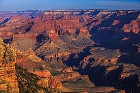
Grand Canyon National Park, located in northwestern Arizona, is the 15th site in the United States to have been named as a national park. The park’s central feature is the Grand Canyon, a gorge of the Colorado River, which is often considered one of the Wonders of the World. The park, which covers 1,217,262 acres (1,901.972 sq mi; 4,926.08 km2) of unincorporated area in Coconino and Mohave counties, received more than six million recreational visitors in 2017, which is the second highest count of all American national parks after Great Smoky Mountains National Park. The Grand Canyon was designated a World Heritage Site by UNESCO in 1979. The park celebrated its 100th anniversary on February 26, 2019.
Read More About Grand Canyon National Park / Source
Everglades National Park

Everglades National Park is an American national park that protects the southern twenty percent of the original Everglades in Florida. The park is the largest tropical wilderness in the United States and the largest wilderness of any kind east of the Mississippi River. An average of one million people visit the park each year. Everglades is the third-largest national park in the contiguous United States after Death Valley and Yellowstone. UNESCO declared the Everglades & Dry Tortugas Biosphere Reserve in 1976 and listed the park as a World Heritage Site in 1979, and the Ramsar Convention included the park on its list of Wetlands of International Importance in 1987. Everglades is one of only three locations in the world to appear on all three lists.Most national parks preserve unique geographic features; Everglades National Park was the first created to protect a fragile ecosystem. The Everglades are a network of wetlands and forests fed by a river flowing 0.25 miles (0.40 km) per day out of Lake Okeechobee, southwest into Florida Bay. The park is the most significant breeding ground for tropical wading birds in North America and contains the largest mangrove ecosystem in the Western Hemisphere. Thirty-six threatened or protected species inhabit the park, including the Florida panther, the American crocodile, and the West Indian manatee, along with 350 species of birds, 300 species of fresh and saltwater fish, 40 species of mammals, and 50 species of reptiles. The majority of South Florida’s fresh water, which is stored in the Biscayne Aquifer, is recharged in the park.Humans have lived for thousands of years in or around the Everglades. Plans arose in 1882 to drain the wetlands and develop the land for agricultural and residential use. As the 20th century progressed, water flow from Lake Okeechobee was increasingly controlled and diverted to enable explosive growth of the Miami metropolitan area. The park was established in 1934, to protect the quickly vanishing Everglades, and dedicated in 1947, as major canal-building projects were initiated across South Florida. The ecosystems in Everglades National Park have suffered significantly from human activity, and restoration of the Everglades is a politically charged issue in South Florida.
Read More About Everglades National Park / Source
Redwood National and State Parks
The Redwood National and State Parks (RNSP) are a complex of one national park and three state parks, cooperatively managed and located in the United States along the coast of northern California. Comprising Redwood National Park (established 1968) and California’s State Parks: Del Norte Coast, Jedediah Smith, and Prairie Creek (dating from the 1920s), the combined RNSP contain 139,000 acres (560 km2), and feature old-growth temperate rainforests. Located within Del Norte and Humboldt Counties, the four parks, protect 45 percent of all remaining coast redwood (Sequoia sempervirens) old-growth forests, totaling at least 38,982 acres (157.75 km2). These trees are the tallest, among the oldest, and one of the most massive tree species on Earth. In addition to the redwood forests, the parks preserve other indigenous flora, fauna, grassland prairie, cultural resources, waterways, and 37 miles (60 km) of pristine coastline.
In 1850, old-growth redwood forest covered more than 2,000,000 acres (8,100 km2) of the California coast. The northern portion of that area was originally inhabited by Native Americans who were forced out of their land by gold seekers and timber harvesters. The enormous redwoods attracted timber harvesters to support the gold rush in more southern regions of California and the increased population from booming development in San Francisco and other places on the West Coast. After many decades of unrestricted clear-cut logging, serious efforts toward conservation began. By 1918 the work of the Save the Redwoods League, founded to preserve remaining old-growth redwoods, resulted in the establishment of Prairie Creek, Del Norte Coast, and Jedediah Smith Redwoods State Parks among others. The federally managed Redwood National Park was created in 1968, by which time nearly 90 percent of the original redwood trees had been logged. In 1994 the National Park Service (NPS) and the California Department of Parks and Recreation (CDPR) administratively combined Redwood National Park with the three abutting Redwood State Parks as a single unit for the purpose of cooperative forest management and stabilization of forests and watersheds.
The ecosystem of the RNSP preserves a number of threatened animal species such as the tidewater goby, Chinook salmon, northern spotted owl, and Steller’s sea lion, though it is believed that the tidewater goby is likely to have been extirpated from the park. In recognition of the rare ecosystem and cultural history found in the parks, the United Nations designated them a World Heritage Site on September 5, 1980. The four redwood parks along with part of the California Coast Ranges were designated an International Biosphere Reserve on June 30, 1983.
Read More About Redwood National and State Parks / Source

Mammoth Cave National Park
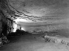
Mammoth Cave National Park is a national park in west-central Kentucky, encompassing portions of Mammoth Cave, the longest cave system known in the world. The park’s 52,830 acres (21,380 ha) are located primarily in Edmonson County, with small areas extending eastward into Hart and Barren counties. The Green River runs through the park, with a tributary called the Nolin River feeding into the Green just inside the park.
The cave system has formally been known as the Mammoth–Flint Ridge Cave System since 1972, when a connection was discovered between Mammoth Cave and the even-longer system under Flint Ridge to the north. As of 2010, more than 420 miles (680 km) passageways had been surveyed, nearly twice as long as the second-longest cave system, Mexico’s Sac Actun underwater cave.The park was established as a national park on July 1, 1941, after oft-contentious eminent-domain proceedings whose consequences still affect the region. It was named a World Heritage Site on October 27, 1981; an international Biosphere Reserve on September 26, 1990; and an International Dark Sky Park on October 28, 2021.
Read More About Mammoth Cave National Park / Source
Olympic National Park
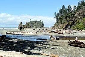
Olympic National Park is a United States national park located in the State of Washington, on the Olympic Peninsula. The park has four regions: the Pacific coastline, alpine areas, the west-side temperate rainforest, and the forests of the drier east side. Within the park there are three distinct ecosystems, including subalpine forest and wildflower meadow, temperate forest, and the rugged Pacific coast.President Theodore Roosevelt originally designated the park as Mount Olympus National Monument on March 2, 1909. The monument was re-designated a national park by Congress and President Franklin D. Roosevelt on June 29, 1938. In 1976, Olympic National Park was designated by UNESCO as an International Biosphere Reserve, and in 1981 as a World Heritage Site. In 1988, Congress designated 95 percent of the park (1,370 square miles (3,500 km2)) as the Olympic Wilderness, which was renamed Daniel J. Evans Wilderness in honor of Governor and U.S. Senator Daniel J. Evans in 2017. During his tenure in the Senate, Evans co-sponsored the 1988 bill that created the state’s wilderness areas. It is the largest wilderness area in Washington.
Read More About Olympic National Park / Source
Cahokia
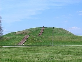
The Cahokia Mounds State Historic Site (11 MS 2) is the site of a pre-Columbian Native American city (which existed c. 1050–1350 CE) directly across the Mississippi River from modern St. Louis, Missouri. This historic park lies in south-western Illinois between East St. Louis and Collinsville. The park covers 2,200 acres (890 ha), or about 3.5 square miles (9 km2), and contains about 80 manmade mounds, but the ancient city was much larger. At its apex around 1100 CE, the city covered about 6 square miles (16 km2) and included about 120 earthworks in a wide range of sizes, shapes, and functions.Cahokia was the largest and most influential urban settlement of the Mississippian culture, which developed advanced societies across much of what is now the Central and the Southeastern United States, beginning more than 1,000 years before European contact. Today, the Cahokia Mounds are considered to be the largest and most complex archaeological site north of the great pre-Columbian cities in Mexico.
Cahokia Mounds is a National Historic Landmark and a designated site for state protection. It is also one of the 24 UNESCO World Heritage Sites within the United States. The largest prehistoric earthen construction in the Americas north of Mexico, the site is open to the public and administered by the Illinois Historic Preservation Division and supported by the Cahokia Mounds Museum Society. In celebration of the 2018 Illinois state bicentennial, the Cahokia Mounds were selected as one of the Illinois 200 Great Places by the American Institute of Architects Illinois component (AIA Illinois). It was recognized by USA Today Travel magazine, as one of the selections for ‘Illinois 25 Must See Places’.
Read More About Cahokia / Source
Statue of Liberty
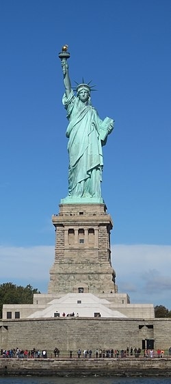
The Statue of Liberty (Liberty Enlightening the World; French: La Liberté éclairant le monde) is a colossal neoclassical sculpture on Liberty Island in New York Harbor in New York City, in the United States. The copper statue, a gift from the people of France, was designed by French sculptor Frédéric Auguste Bartholdi and its metal framework was built by Gustave Eiffel. The statue was dedicated on October 28, 1886.
The statue is a figure of Libertas, a robed Roman liberty goddess. She holds a torch above her head with her right hand, and in her left hand carries a tabula ansata inscribed JULY IV MDCCLXXVI (July 4, 1776 in Roman numerals), the date of the U.S. Declaration of Independence. A broken shackle and chain lie at her feet as she walks forward, commemorating the recent national abolition of slavery. After its dedication, the statue became an icon of freedom and of the United States, seen as a symbol of welcome to immigrants arriving by sea.
Bartholdi was inspired by a French law professor and politician, Édouard René de Laboulaye, who is said to have commented in 1865 that any monument raised to U.S. independence would properly be a joint project of the French and American peoples. The Franco-Prussian War delayed progress until 1875, when Laboulaye proposed that the French finance the statue and the United States provide the site and build the pedestal. Bartholdi completed the head and the torch-bearing arm before the statue was fully designed, and these pieces were exhibited for publicity at international expositions.
The torch-bearing arm was displayed at the Centennial Exposition in Philadelphia in 1876, and in Madison Square Park in Manhattan from 1876 to 1882. Fundraising proved difficult, especially for the Americans, and by 1885 work on the pedestal was threatened by lack of funds. Publisher Joseph Pulitzer, of the New York World, started a drive for donations to finish the project and attracted more than 120,000 contributors, most of whom gave less than a dollar (equivalent to $30 in 2021). The statue was built in France, shipped overseas in crates, and assembled on the completed pedestal on what was then called Bedloe’s Island. The statue’s completion was marked by New York’s first ticker-tape parade and a dedication ceremony presided over by President Grover Cleveland.
The statue was administered by the United States Lighthouse Board until 1901 and then by the Department of War; since 1933 it has been maintained by the National Park Service as part of the Statue of Liberty National Monument, and is a major tourist attraction. Limited numbers of visitors can access the rim of the pedestal and the interior of the statue’s crown from within; public access to the torch has been barred since 1916.
Read More About Statue of Liberty / Source
Yosemite National Park
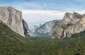
Yosemite National Park ( yoh-SEM-ih-tee) is an American national park in California, surrounded on the southeast by Sierra National Forest and on the northwest by Stanislaus National Forest. The park is managed by the National Park Service and covers an area of 759,620 acres (1,187 sq mi; 3,074 km2) in four counties – centered in Tuolumne and Mariposa, extending north and east to Mono and south to Madera County. Designated a World Heritage Site in 1984, Yosemite is internationally recognized for its cliffs, waterfalls, clear streams, giant sequoia groves, lakes, mountains, meadows, glaciers, and biological diversity. Almost 95 percent of the park is designated wilderness. Yosemite is one of the largest and least fragmented habitat blocks in the Sierra Nevada, and the park supports a diversity of plants and animals.
The geology of the Yosemite area is characterized by granite rocks and remnants of older rock. About 10 million years ago, the Sierra Nevada was uplifted and tilted to form its unique slopes, which increased the steepness of stream and river beds, resulting in the formation of deep, narrow canyons. About one million years ago glaciers formed at higher elevations which eventually melted and moved downslope, cutting and sculpting the U-shaped valley that attracts so many visitors to its scenic vistas.European American settlers first entered Yosemite Valley itself in 1851. There are earlier instances of other travelers entering the Valley but James D. Savage is credited with discovering the area that became Yosemite National Park. Despite Savage and others claiming their discovery of Yosemite, the region and Valley itself have been inhabited for nearly 4,000 years, although humans may have visited the area as long as 8,000 to 10,000 years ago.Yosemite was critical to the development of the national park idea. Galen Clark and others lobbied to protect Yosemite Valley from development, ultimately leading to President Abraham Lincoln’s signing of the Yosemite Grant of 1864 which declared Yosemite as federally preserved land. It was not until 1890 that John Muir led a successful movement which had Congress establish Yosemite Valley and its surrounding areas as a National Park. This helped pave the way for the National Park System. Yosemite draws about four million visitors each year, and most visitors spend the majority of their time in the seven square miles (18 km2) of Yosemite Valley. The park set a visitation record in 2016, surpassing five million visitors for the first time in its history. The park began requiring reservations to access the park during peak periods starting in 2020 as a response to the rise in visitors.
Read More About Yosemite National Park / Source
Chaco Culture National Historical Park

Chaco Culture National Historical Park is a United States National Historical Park in the American Southwest hosting a concentration of pueblos. The park is located in northwestern New Mexico, between Albuquerque and Farmington, in a remote canyon cut by the Chaco Wash. Containing the most sweeping collection of ancient ruins north of Mexico, the park preserves one of the most important pre-Columbian cultural and historical areas in the United States.Between AD 900 and 1150, Chaco Canyon was a major center of culture for the Ancestral Puebloans. Chacoans quarried sandstone blocks and hauled timber from great distances, assembling fifteen major complexes that remained the largest buildings ever built in North America until the 19th century. Evidence of archaeoastronomy at Chaco has been proposed, with the “Sun Dagger” petroglyph at Fajada Butte a popular example. Many Chacoan buildings may have been aligned to capture the solar and lunar cycles, requiring generations of astronomical observations and centuries of skillfully coordinated construction. Climate change is thought to have led to the emigration of Chacoans and the eventual abandonment of the canyon, beginning with a fifty-year drought commencing in 1130.Comprising a UNESCO World Heritage Site located in the arid and sparsely populated Four Corners region, the Chacoan cultural sites are fragile—concerns of erosion caused by tourists have led to the closure of Fajada Butte to the public. The sites are considered sacred ancestral homelands by the Hopi and Pueblo people, who maintain oral accounts of their historical migration from Chaco and their spiritual relationship to the land. Although park preservation efforts can conflict with native religious beliefs, tribal representatives work closely with the National Park Service to share their knowledge and respect the heritage of the Chacoan culture.The park is on the Trails of the Ancients Byway, one of the designated New Mexico Scenic Byways.
Read More About Chaco Culture National Historical Park / Source
Hawaiʻi Volcanoes National Park
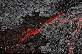
Hawaiʻi Volcanoes National Park is an American national park located in the U.S. state of Hawaii on the island of Hawaii. The park encompasses two active volcanoes: Kīlauea, one of the world’s most active volcanoes, and Mauna Loa, the world’s most massive shield volcano. The park provides scientists with insight into the development of the Hawaiian Islands and access for studies of volcanism. For visitors, the park offers dramatic volcanic landscapes, glimpses of rare flora and fauna, and a view into the traditional Hawaiian culture connected to these landscapes.
The park was originally established on August 1, 1916, as Hawaii National Park, which was then split into this park and Haleakalā National Park. In recognition of its outstanding natural values, Hawaiʻi Volcanoes National Park was designated as an International Biosphere Reserve in 1980 and a World Heritage Site in 1987. In 2012, the park was depicted on the 14th quarter of the America the Beautiful Quarters series.
On May 11, 2018, the park was closed to the public in the Kīlauea volcano summit area, including the visitor center and park headquarters, due to explosions and toxic ash clouds from Halemaʻumaʻu, as well as earthquakes and road damage. Portions of the park, including the visitor center, reopened to the public on September 22, 2018. As of early 2022, most of the park is open; however, some road segments and trails as well as the Jaggar Museum of the Hawaiian Volcano Observatory are still closed to visitors.Eruptive activity, ground collapses and explosions in the park ceased in early August 2018, and the lull in eruptive activity at Kīlauea continued until an eruption on December 20, 2020, at the Halemaʻumaʻu crater.
Read More About Hawaiʻi Volcanoes National Park / Source
Monticello
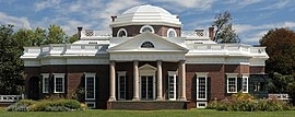
Monticello ( MON-tih-CHEL-oh) was the primary plantation of Founding Father Thomas Jefferson, the third president of the United States, who began designing Monticello after inheriting land from his father at age 26. Located just outside Charlottesville, Virginia, in the Piedmont region, the plantation was originally 5,000 acres (20 km2), with Jefferson using the labor of enslaved Africans for extensive cultivation of tobacco and mixed crops, later shifting from tobacco cultivation to wheat in response to changing markets. Due to its architectural and historic significance, the property has been designated a National Historic Landmark. In 1987, Monticello and the nearby University of Virginia, also designed by Jefferson, were together designated a UNESCO World Heritage Site. The current nickel, a United States coin, features a depiction of Monticello on its reverse side.
Jefferson designed the main house using neoclassical design principles described by Italian Renaissance architect Andrea Palladio and reworking the design through much of his presidency to include design elements popular in late 18th-century Europe and integrating numerous ideas of his own. Situated on the summit of an 850 ft (260 m)-high peak in the Southwest Mountains south of the Rivanna Gap, the name Monticello derives from Italian meaning “little mountain”. Along a prominent lane adjacent to the house, Mulberry Row, the plantation came to include numerous outbuildings for specialized functions, e.g., a nailery; quarters for enslaved Africans who worked in the home; gardens for flowers, produce, and Jefferson’s experiments in plant breeding—along with tobacco fields and mixed crops. Cabins for enslaved Africans who worked in the fields were farther from the mansion.At Jefferson’s direction, he was buried on the grounds, in an area now designated as the Monticello Cemetery. The cemetery is owned by the Monticello Association, a society of his descendants through Martha Wayles Skelton Jefferson. After Jefferson’s death, his daughter Martha Jefferson Randolph, apart from the small cemetery, sold Monticello. In 1834, it was bought by Uriah P. Levy, a commodore in the U.S. Navy, who admired Jefferson and spent his own money to preserve the property. His nephew Jefferson Monroe Levy took over the property in 1879; he also invested considerable money to restore and preserve it. In 1923, Monroe Levy sold it to the Thomas Jefferson Foundation (TJF), which operates it as a house museum and educational institution.
Read More About Monticello / Source
University of Virginia
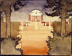
The University of Virginia (UVA) is a public research university in Charlottesville, Virginia. Founded in 1819 by Thomas Jefferson, the university is ranked among the top academic institutions in the United States, with highly selective admission and an acceptance rate of 16% in 2023. Set within the Academical Village, a UNESCO World Heritage Site, the university is referred to as a “Public Ivy” for offering an academic experience similar to that of an Ivy League university. It is known in part for certain rare characteristics among public universities such as its historic foundations, student-run honor code, and secret societies.The original governing Board of Visitors included three U.S. presidents: Jefferson, James Madison, and James Monroe. The latter as sitting President of the United States at the time of its foundation. As its first two rectors, Presidents Jefferson and Madison played key roles in the university’s foundation, with Jefferson designing both the original courses of study and the university’s architecture. Located within its historic 1,135 acre central campus, the university is composed of eight undergraduate and three professional schools: the School of Law, the Darden School of Business, and the School of Medicine.The University of Virginia’s scholars have played a major role in the development of many academic disciplines, including economics, law, literary art, visual art, and the sciences. In research, the university has been a member of the Association of American Universities for 119 years, and the journal Science credited its faculty with two of the top ten global scientific breakthroughs in a single year. In sports, the university athletic teams are called the Cavaliers and lead the Atlantic Coast Conference in team NCAA Championships for men’s sports, also ranking second in women’s and overall titles. In 2015, and again in 2019, the University of Virginia was presented with the Capital One Cup for fielding the nation’s best overall athletics programs for men’s sports.The university’s alumni, faculty, and researchers have included several U.S. presidents, heads of state, Nobel laureates, Pulitzer Prize winners, Rhodes Scholars, Marshall Scholars, and Fulbright Scholars. Some 30 different governors of U.S. states have attended the university, as have numerous U.S. senators and congresspeople. UVA has produced 55 Rhodes Scholars, eighth highest in the United States, while its alumni have founded numerous companies (such as Reddit, CNET, and Space Adventures) which together produce more than $1.6 trillion in annual revenue and have created 2.3 million jobs.
Read More About University of Virginia / Source

Taos Pueblo
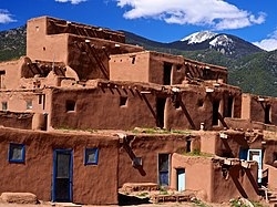
Taos Pueblo (or Pueblo de Taos) is an ancient pueblo belonging to a Taos-speaking (Tiwa) Native American tribe of Puebloan people. It lies about 1 mile (1.6 km) north of the modern city of Taos, New Mexico. The pueblos are considered to be one of the oldest continuously inhabited communities in the United States. This has been designated a UNESCO World Heritage Site.
Taos Pueblo is a member of the Eight Northern Pueblos. Natives will almost never speak of their religious customs to outsiders, and, because their language has never been written down, much of the culture remains unknown to the rest of the world. A tribal land of 95,000 acres (38,000 ha) is attached to the pueblo, and about 4,500 people live in this area.
Read More About Taos Pueblo / Source
Carlsbad Caverns National Park

Carlsbad Caverns National Park is an American national park in the Guadalupe Mountains of southeastern New Mexico. The primary attraction of the park is the show cave Carlsbad Cavern. Visitors to the cave can hike in on their own via the natural entrance or take an elevator from the visitor center.
The park entrance is located on US Highway 62/180, approximately 18 miles (29 km) southwest of Carlsbad, New Mexico. Carlsbad Caverns National Park participates in the Junior Ranger Program. The park has two entries on the National Register of Historic Places: The Caverns Historic District and the Rattlesnake Springs Historic District. Approximately two-thirds of the park has been set aside as a wilderness area, helping to ensure no future changes will be made to the habitat.
Carlsbad Cavern includes a large limestone chamber, named simply the Big Room, which is almost 4,000 ft (1,220 m) long, 625 ft (191 m) wide, and 255 ft (78 m) high at its highest point. The Big Room is the largest chamber in North America and the 32nd largest in the world.
Read More About Carlsbad Caverns National Park / Source

Waterton-Glacier International Peace Park
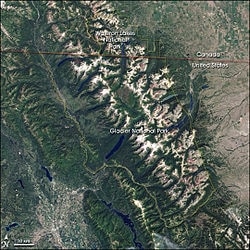
The Waterton-Glacier International Peace Park is the union of Waterton Lakes National Park in Canada and Glacier National Park in the United States. Both parks are declared Biosphere Reserves by UNESCO and their union as a World Heritage Site.
Read More About Waterton-Glacier International Peace Park / Source
Papahānaumokuākea Marine National Monument
The Papahānaumokuākea Marine National Monument (PMNM) (roughly ) is a World Heritage listed U.S. National Monument encompassing 583,000 square miles (1,510,000 km2) of ocean waters, including ten islands and atolls of the Northwestern Hawaiian Islands. It was created in June 2006 with 140,000 square miles (360,000 km2) and expanded in August 2016 by moving its border to the limit of the exclusive economic zone, making it one of the world’s largest protected areas. It is internationally known for its cultural and natural values as follows:
The area has deep cosmological and traditional significance for living Native Hawaiian culture, as an ancestral environment, as an embodiment of the Hawaiian concept of kinship between people and the natural world, and as the place where it is believed that life originates and to where the spirits return after death. On two of the islands, Nihoa and Mokumanamana, there are archaeological remains relating to pre-European settlement and use. Much of the monument is made up of pelagic and deepwater habitats, with notable features such as seamounts and submerged banks, extensive coral reefs and lagoons.
Read More About Papahānaumokuākea Marine National Monument / Source
San Antonio Missions
The San Antonio Missions are a World Heritage Site located in and near San Antonio, Texas, United States. The World Heritage Site consists of five mission sites, a historic ranch, and related properties. These outposts were established by Catholic religious orders to spread Christianity among the local natives. These missions formed part of a colonization system that stretched across the Spanish Southwest in the 17th, 18th, and 19th centuries.
They were inscribed on the World Heritage List in 2015. Their architectural designs combine Spanish and Coahuiltecan cultures, including Catholic symbols and indigenous designs. They also process the remains of water distribution systems, that shows the combination of the indigenous and colonizers cultures.
Read More About San Antonio Missions / Source
Dayton Aviation Heritage National Historical Park
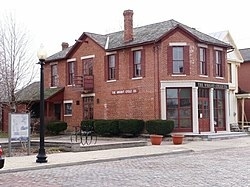
Dayton Aviation Heritage National Historical Park is a United States National Historical Park in Dayton, Ohio that commemorates three important historical figures—Wilbur Wright, Orville Wright, and poet Paul Laurence Dunbar—and their work in the Miami Valley.
Read More About Dayton Aviation Heritage National Historical Park / Source
Mount Vernon

Mount Vernon is an American landmark and former plantation of Founding Father, commander of the Continental Army in the Revolutionary War, and the first president of the United States George Washington and his wife, Martha. The estate is on the banks of the Potomac River in Fairfax County, Virginia. It is located south of Washington, D.C., and Alexandria, Virginia, and is across the river from Prince George’s County, Maryland.
The Washington family acquired land in the area in 1674. Around 1734, the family embarked on an expansion of its estate that continued under George Washington, who began leasing the estate in 1754 before becoming its sole owner in 1761.The mansion was built of wood in a loose Palladian style; the original house was built by George Washington’s father Augustine, around 1734. George Washington expanded the house twice, once in the late 1750s and again in the 1770s. It remained Washington’s home for the rest of his life. Following his death in 1799, under the ownership of several successive generations of the family, the estate progressively declined as revenues were insufficient to maintain it adequately.
In 1858, the house’s historical importance was recognized and it was taken over by the Mount Vernon Ladies’ Association; this organization acquired it together with part of the Washington property estate. The mansion and its surrounding buildings did escape damage from the American Civil War suffered by many properties located within the Confederate States of America.
Mount Vernon was designated a National Historic Landmark in 1960 and is listed on the National Register of Historic Places. It is still owned and maintained in trust by the Mount Vernon Ladies’ Association, being daily open to the public. Allowing people to see the estate is part of an over 200-year-old tradition started by George Washington. In 1794 he wrote: “I have no objection to any sober or orderly person’s gratifying their curiosity in viewing the buildings, Gardens, &ca. about Mount Vernon.”
Read More About Mount Vernon / Source
Serpent Mound

The Great Serpent Mound is a 1,348-foot-long (411 m), three-foot-high prehistoric effigy mound located in Peebles, Ohio. It was built on what is known as the Serpent Mound crater plateau, running along the Ohio Brush Creek in Adams County, Ohio. The mound is the largest serpent effigy in the world.
The first published surveys of the mound were by Ephraim G. Squier and Edwin Hamilton Davis, featured in their historic volume, Ancient Monuments of the Mississippi Valley (1848), commissioned by the Smithsonian Institution.
The United States Department of Interior designated the mound as a National Historic Landmark in 1966. The mound is maintained through the Ohio History Connection, a non-profit organization dedicated to preserving historical sites throughout Ohio.
Read More About Serpent Mound / Source
Okefenokee National Wildlife Refug
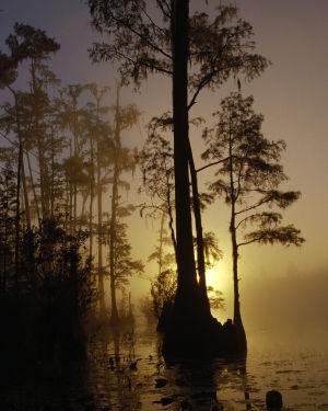
The Okefenokee National Wildlife Refuge is a 402,000‑acre (1,627 km2) National Wildlife Refuge located in Charlton, Ware, and Clinch Counties of Georgia, and Baker County in Florida, United States. The refuge is administered from offices in Folkston, Georgia. The refuge was established in 1937 to protect a majority of the 438,000 acre (1,772 km2) Okefenokee Swamp. The name “Okefenokee” is a Native American word meaning “trembling earth.”A wildfire which began with a lightning strike near the center of the Refuge on May 5, 2007 eventually merged with another wildfire which had begun near Waycross, Georgia on April 16 due to a tree falling on a power line. By May 28, more than 580,000 acres (2,300 km2) had burned in the region, or more than 900 square miles (2300 km2).Nearly 400,000 people visit the refuge each year, making it the 16th most visited refuge in the National Wildlife Refuge System. It is the largest in acreage of any that is not located in a western state. In 1999, the economic impact of tourism in Charlton, Ware, and Clinch Counties in Georgia exceeded $67 million. The refuge has a staff of 16 with a fiscal year 2005 budget of $1,451,000. The refuge also administers the Banks Lake National Wildlife Refuge.
Read More About Okefenokee National Wildlife Refug / Source
White Sands National Park
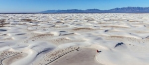
White Sands National Park is an American national park located in the state of New Mexico and completely surrounded by the White Sands Missile Range. The park covers 145,762 acres (227.8 sq mi; 589.9 km2) in the Tularosa Basin, including the southern 41% of a 275 sq mi (710 km2) field of white sand dunes composed of gypsum crystals. This gypsum dunefield is the largest of its kind on Earth, with a depth of about 30 feet (9.1 m), dunes as tall as 60 feet (18 m), and about 4.5 billion short tons (4.1 billion metric tons) of gypsum sand.
Approximately 12,000 years ago, the land within the Tularosa Basin featured large lakes, streams, grasslands, and Ice Age mammals. As the climate warmed, rain and snowmelt dissolved gypsum from the surrounding mountains and carried it into the basin. Further warming and drying caused the lakes to evaporate and form selenite crystals. Strong winds then broke up crystals and transported them eastward. A similar process continues to produce gypsum sand today.Thousands of species of animal inhabit the park, a large portion of which are invertebrates. Several animal species feature a white or off-white coloration. At least 45 species are endemic, living only in this park, with 40 of them being moth species. The Tularosa Basin has also seen a number of human inhabitants, from Paleo-Indians 12,000 years ago to modern farmers, ranchers, and miners.
White Sands National Park was originally designated White Sands National Monument on January 18, 1933 by President Herbert Hoover; it was redesignated as a national park by Congress and signed into law by President Donald Trump on December 20, 2019. It is the most visited NPS site in New Mexico, with about 600,000 visitors each year. The park features a drive from the visitor center to the heart of the dunes, picnic areas, backcountry campground in the dunefield, marked hiking trails, and sledding on the dunes. Ranger-guided orientation and nature walks occur at various times and months throughout the year.
Read More About White Sands National Park / Source
Brooklyn Bridge
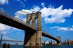
The Brooklyn Bridge is a hybrid cable-stayed/suspension bridge in New York City, spanning the East River between the boroughs of Manhattan and Brooklyn. Opened on May 24, 1883, the Brooklyn Bridge was the first fixed crossing of the East River. It was also the longest suspension bridge in the world at the time of its opening, with a main span of 1,595.5 feet (486.3 m) and a deck 127 ft (38.7 m) above mean high water. The span was originally called the New York and Brooklyn Bridge or the East River Bridge but was officially renamed the Brooklyn Bridge in 1915.
Proposals for a bridge connecting Manhattan and Brooklyn were first made in the early 19th century, which eventually led to the construction of the current span, designed by John A. Roebling. The project’s chief engineer, his son Washington Roebling, contributed further design work, assisted by the latter’s wife, Emily Warren Roebling. Construction started in 1870, with the Tammany Hall-controlled New York Bridge Company overseeing construction, although numerous controversies and the novelty of the design prolonged the project over thirteen years. Since opening, the Brooklyn Bridge has undergone several reconfigurations, having carried horse-drawn vehicles and elevated railway lines until 1950. To alleviate increasing traffic flows, additional bridges and tunnels were built across the East River. Following gradual deterioration, the Brooklyn Bridge has been renovated several times, including in the 1950s, 1980s, and 2010s.
The Brooklyn Bridge is the southernmost of the four toll-free vehicular bridges connecting Manhattan Island and Long Island, with the Manhattan Bridge, the Williamsburg Bridge, and the Queensboro Bridge to the north. Only passenger vehicles and pedestrian and bicycle traffic are permitted. A major tourist attraction since its opening, the Brooklyn Bridge has become an icon of New York City. Over the years, the bridge has been used as the location of various stunts and performances, as well as several crimes and attacks. The Brooklyn Bridge has been designated a National Historic Landmark, a New York City landmark, and a National Historic Civil Engineering Landmark.
Read More About Brooklyn Bridge / Source
Ellis Island
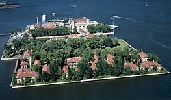
Ellis Island is a federally owned island in New York Harbor, situated within the U.S. states of New Jersey and New York, that was the busiest immigrant inspection and processing station in the United States. From 1892 to 1954, nearly 12 million immigrants arriving at the Port of New York and New Jersey were processed there under federal law. Today, it is part of the Statue of Liberty National Monument and is accessible to the public only by ferry. The north side of the island is the site of the main building, now a national museum of immigration. The south side of the island, including the Ellis Island Immigrant Hospital, is open to the public only through guided tours.
In the 19th century, Ellis Island was the site of Fort Gibson and later became a naval magazine. The first inspection station opened in 1892 and was destroyed by fire in 1897. The second station opened in 1900 and housed facilities for medical quarantines and processing immigrants. After 1924, Ellis Island was used primarily as a detention center for migrants. During both World War I and World War II, its facilities were also used by the US military to detain prisoners of war. After the immigration station’s closure, the buildings languished for several years until they were partially reopened in 1976. The main building and adjacent structures were completely renovated in 1990.
The 27.5-acre (11.1 ha) island was greatly expanded by land reclamation between the late 1890s and the 1930s. Jurisdictional disputes between New Jersey and New York State persisted until the 1998 US Supreme Court ruling in New Jersey v. New York.
Read More About Ellis Island / Source
Central Park
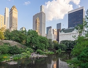
Central Park is an urban park in New York City located between the Upper West and Upper East Sides of Manhattan. It is the fifth-largest park in the city, covering 843 acres (341 ha). It is the most visited urban park in the United States, with an estimated 42 million visitors annually as of 2016, and is the most filmed location in the world.
After proposals for a large park in Manhattan during the 1840s, it was approved in 1853 to cover 778 acres (315 ha). In 1857, landscape architects Frederick Law Olmsted and Calvert Vaux won a design competition for the park with their “Greensward Plan”. Construction began the same year; existing structures, including a majority-Black settlement named Seneca Village, were seized through eminent domain and razed. The park’s first areas were opened to the public in late 1858. Additional land at the northern end of Central Park was purchased in 1859, and the park was completed in 1876. After a period of decline in the early 20th century, New York City parks commissioner Robert Moses started a program to clean up Central Park in the 1930s. The Central Park Conservancy, created in 1980 to combat further deterioration in the late 20th century, refurbished many parts of the park starting in the 1980s.
Main attractions include landscapes such as the Ramble and Lake, Hallett Nature Sanctuary, the Jacqueline Kennedy Onassis Reservoir, and Sheep Meadow; amusement attractions such as Wollman Rink, Central Park Carousel, and the Central Park Zoo; formal spaces such as the Central Park Mall and Bethesda Terrace; and the Delacorte Theater. The biologically diverse ecosystem has several hundred species of flora and fauna. Recreational activities include carriage-horse and bicycle tours, bicycling, sports facilities, and concerts and events such as Shakespeare in the Park. Central Park is traversed by a system of roads and walkways and is served by public transportation.
Its size and cultural position make it a model for the world’s urban parks. Its influence earned Central Park the designations of National Historic Landmark in 1963 and of New York City scenic landmark in 1974. Central Park is owned by the New York City Department of Parks and Recreation but has been managed by the Central Park Conservancy since 1998, under a contract with the municipal government in a public–private partnership. The Conservancy, a non-profit organization, raises Central Park’s annual operating budget and is responsible for all basic care of the park.
Read More About Central Park / Source
Early Chicago Skyscrapers

Early Chicago Skyscrapers is a nomination comprising nine buildings in Chicago’s Loop district for inclusion on UNESCO’s World Heritage Site list. Submitted by the US Department of the Interior in 2017, it is currently on the tentative list considered for nomination as a UNESCO designated World Heritage Site. Only properties that have been previously listed on a tentative list can be nominated for the World Heritage List.These buildings were constructed in the last 20 years of the 19th century and represent the first generation of “skyscrapers”, high-rise structures reaching up to 20 stories. Construction of these buildings employed novel approaches and technologies, such as the use of steel frames, first elevators, electric lights, and terracotta fireproofing. The architects developed a new aesthetics for the exterior of this new type of buildings. The skyscrapers listed are the Auditorium Building (pictured), Second Leiter Building, Marquette Building, Rookery Building, Monadnock Building, Old Colony Building, Fisher Building, Schlesinger & Mayer Building, and Ludington Building.
Read More About Early Chicago Skyscrapers / Source
Pacific Remote Islands Marine National Monument

The Pacific Remote Islands Marine National Monument is a group of unorganized, mostly unincorporated United States Pacific Island territories managed by the United States Fish and Wildlife Service of the United States Department of the Interior and the National Oceanic and Atmospheric Administration (NOAA) of the United States Department of Commerce. These remote refuges are “the most widespread collection of marine- and terrestrial-life protected areas on the planet under a single country’s jurisdiction”. They protect many endemic species including corals, fish, shellfish, marine mammals, seabirds, water birds, land birds, insects, and vegetation not found elsewhere.
Read More About Pacific Remote Islands Marine National Monument / Source
Marianas Trench Marine National Monument

The Marianas Trench Marine National Monument is a United States National Monument created by President George W. Bush by the presidential proclamation no. 8335 on January 6, 2009. The monument includes no dry land area, but protects 95,216 square miles (246,610 km2) of submerged lands and waters in various places in the Mariana Archipelago. The United States could create this monument under international law because the maritime exclusive economic zones of the adjacent Northern Mariana Islands and Guam fall within its jurisdiction.
Read More About Marianas Trench Marine National Monument / Source
Big Bend National Park
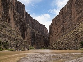
Big Bend National Park is an American national park located in West Texas, bordering Mexico. The park has national significance as the largest protected area of Chihuahuan Desert topography and ecology in the United States, and was named after a large bend in the Rio Grande/Río Bravo. The park protects more than 1,200 species of plants, more than 450 species of birds, 56 species of reptiles, and 75 species of mammals. Additional park activities include scenic drives, programs led by Big Bend park rangers, and stargazing.The area has a rich cultural history, from archeological sites dating back nearly 10,000 years to more recent pioneers, ranchers, and miners. The Chisos Mountains are located in the park, and are the only mountain range in the United States to be fully contained within the boundary of a national park. Geological features in the park include sea fossils and dinosaur bones, as well as volcanic dikes.
The park encompasses an area of 801,163 acres (1,251.8 sq mi; 3,242.2 km2), entirely within Brewster County. For more than 1,000 miles (1,600 km), the Rio Grande/Río Bravo forms the boundary between Mexico and the United States, and Big Bend National Park administers approximately 118 miles (190 km) along that boundary.Because the Rio Grande serves as an international boundary, the park faces unusual constraints while administering and enforcing park rules, regulations, and policies. In accordance with the Treaty of Guadalupe Hidalgo, the park’s territory extends only to the center of the deepest river channel as the river flowed in 1848. The rest of the channel and the land south of it lies within Mexican territory. The park is bordered by the protected areas of Cañón de Santa Elena and Maderas del Carmen in Mexico.
Read More About Big Bend National Park / Source
Poverty Point

Poverty Point State Historic Site/Poverty Point National Monument (French: Pointe de Pauvreté; 16 WC 5) is a prehistoric earthwork constructed by the Poverty Point culture, located in present-day northeastern Louisiana. Evidence of the Poverty Point culture extends throughout much of the Southeastern Woodlands of the Southern United States. The culture extended 100 miles (160 km) across the Mississippi Delta and south to the Gulf Coast.
The Poverty Point site has been designated as a state historic site, U.S. National Monument, a U.S. National Historic Landmark, and UNESCO World Heritage Site. The site is 15.5 miles (24.9 km) from the current flow of the Mississippi River, and is situated on the edge of Macon Ridge. The village of Epps developed in the historic period in West Carroll Parish, Louisiana.
The Poverty Point site contains earthen ridges and mounds, built by indigenous people between 1700 and 1100 BCE during the Late Archaic period in North America. Archaeologists have proposed a variety of possible functions for the site, including as a settlement, a trading center, and/or a ceremonial religious complex.
The 402-acre (163 ha) property now operated as the Poverty Point State Historic Site contains “the largest and most complex Late Archaic earthwork occupation and ceremonial site yet found in North America”. Euroamericans described the site in the 19th century. Since the 1950s Poverty Point has been the focus of professional archaeological excavations. The earthworks are named after a 19th-century plantation on the property.
Read More About Poverty Point / Source
Keywords:
Best Heritage Sites in America Most Popular Heritage Sites in USA Famous Heritage Sites in America