83 Most Dangerous and Deadly Volcanic Eruptions

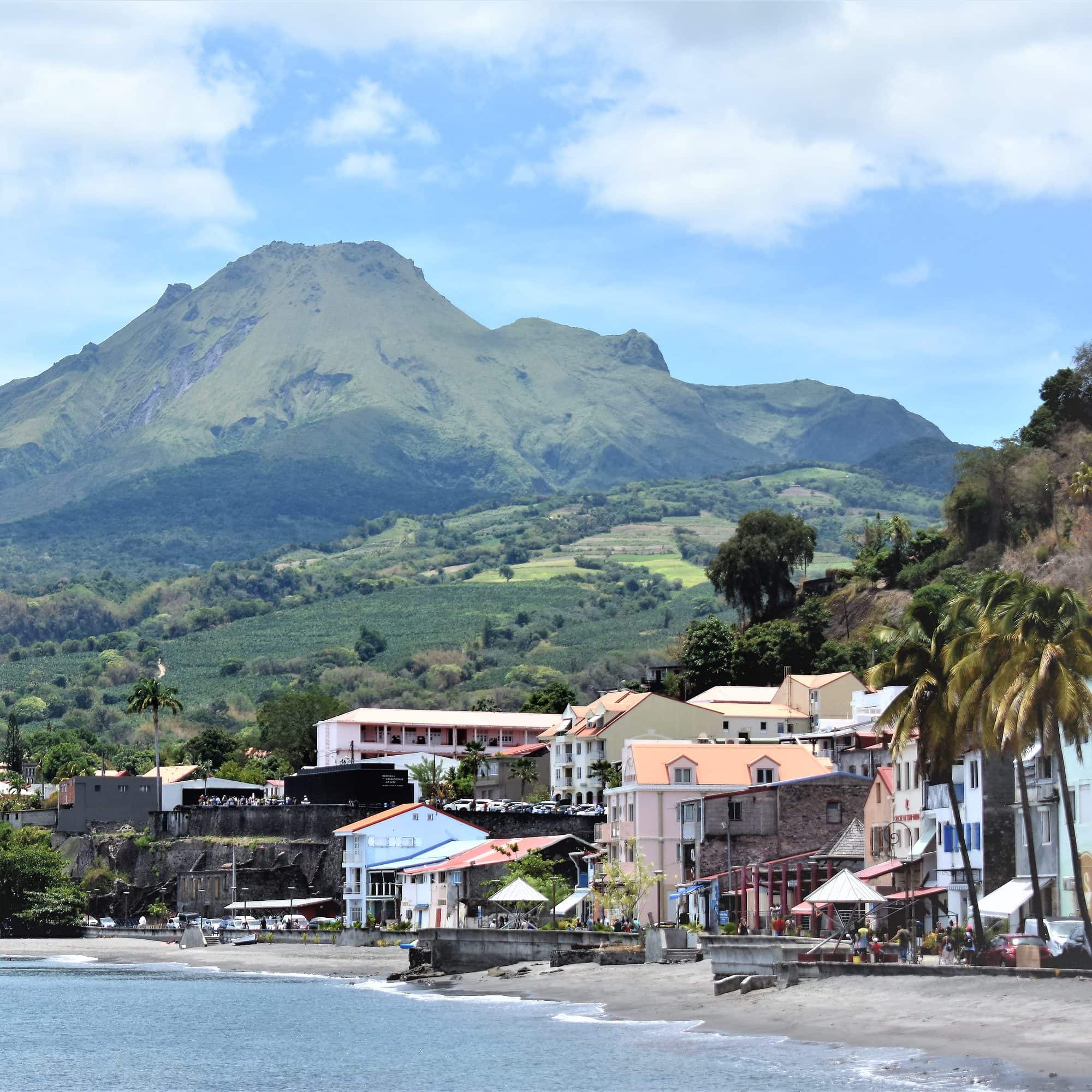
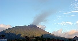
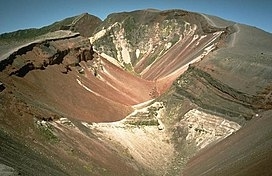
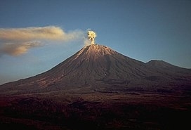
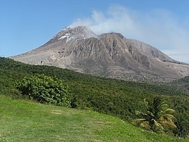
Mount Pelée
Year- 1902
Total Death- 30000+
Location- Martinique
Mount Pelée or Mont Pelée ( pə-LAY; French: Montagne Pelée, [mɔ̃taɲ pəle]; Antillean Creole: Montann Pèlé, meaning “bald mountain” or “peeled mountain”) is an active volcano at the northern end of Martinique, an island and French overseas department in the Lesser Antilles Volcanic Arc of the Caribbean. Its volcanic cone is composed of stratified layers of hardened ash and solidified lava. Its most recent eruption was in 1932.The stratovolcano’s 1902 eruption destroyed the town of Saint-Pierre, killing 29,000 to 30,000 people in the space of a few minutes, in the worst volcanic disaster of the 20th century. The main eruption, on 8 May 1902, left only two survivors in the direct path of the blast flow: Ludger Sylbaris survived because he was in a poorly ventilated, dungeon-like jail cell, and Léon Compère-Léandre, living on the edge of the city, escaped with severe burns.
Read More About Mount Pelée / Source
Mount Tambora
Year- 1815
Total Death- 71,000 to 250,100+
Location- Indonesia
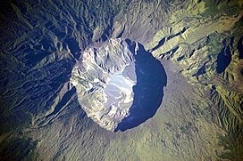
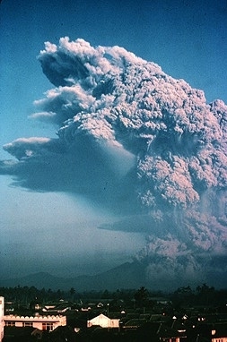
Mount Tambora, or Tomboro, is an active stratovolcano in West Nusa Tenggara, Indonesia. Located on Sumbawa in the Lesser Sunda Islands, it was formed by the active subduction zones beneath it. Before 1815, its elevation reached more than 4,300 metres (14,100 feet) high, making it one of the tallest peaks in the Indonesian archipelago.
Tambora violently erupted in a series of eruptions beginning 5 April, 1815, culminating in the largest eruption in recorded human history and the largest of the Holocene (10,000 years ago to present). The magma chamber under Tambora had been drained by previous eruptions and underwent several centuries of dormancy as it refilled. Volcanic activity reached a peak that year, culminating in an explosive eruption. The explosion was heard on Sumatra island, more than 2,000 kilometres (1,200 miles) away. Heavy volcanic ash rains were observed as far away as Borneo, Sulawesi, Java, and Maluku islands, and the maximum elevation of Tambora was reduced from about 4,300 metres (14,100 ft) to 2,850 metres (9,350 feet). Although estimates vary, the death toll was at least 71,000 people. The eruption contributed to global climate anomalies in the following years, while 1816 became known as the “year without a summer” because of the impact on North American and European weather. In the Northern Hemisphere, crops failed and livestock died, resulting in the worst famine of the century.
Read More About Mount Tambora / Source
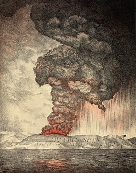
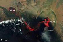
Krakatoa
Year- 1883
Total Death- 36000+
Location- Indonesia
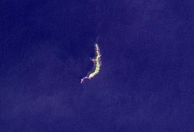
Krakatoa , also transcribed Krakatau , is a caldera in the Sunda Strait between the islands of Java and Sumatra in the Indonesian province of Lampung. The caldera is part of a volcanic island group (Krakatoa archipelago) comprising four islands. Two, Lang and Verlaten, are remnants of a previous volcanic edifice destroyed in eruptions long before the famous 1883 eruption; another, Rakata, is the remnant of a much larger island destroyed in the 1883 eruption.
In 1927, a fourth island, Anak Krakatoa, or “Child of Krakatoa”, emerged from the caldera formed in 1883. There has been new eruptive activity since the late 20th century, with a large collapse causing a deadly tsunami in December 2018.
Read More About Krakatoa / Source
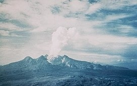
Nevado del Ruiz

Year- 1985
Total Death- 23000
Location- Columbia
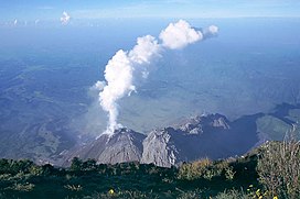
The Nevado del Ruiz (Spanish pronunciation: [neβaðo ðel ˈrwis]), also known as La Mesa de Herveo (English: Mesa of Herveo, the name of the nearby town) is a volcano on the border of the departments of Caldas and Tolima in Colombia, about 129 km (80 mi) west of the capital city Bogotá. It is a stratovolcano composed of many layers of lava alternating with hardened volcanic ash and other pyroclastic rocks. Volcanic activity at Nevado del Ruiz began about two million years ago, since the Early Pleistocene or Late Pliocene, with three major eruptive periods. The current volcanic cone formed during the present eruptive period, which began 150,000 years ago.
The volcano usually generates Vulcanian to Plinian eruptions, which produce swift-moving currents of hot gas and rock called pyroclastic flows. These eruptions often cause massive lahars (mud and debris flows), which pose a threat to human life and the environment. The impact of such an eruption is increased as the hot gas and lava melt the mountain’s snowcap, adding large quantities of water to the flow. On November 13, 1985, a small eruption produced an enormous lahar that buried and destroyed the town of Armero in Tolima, causing an estimated 25,000 deaths. This event later became known as the Armero tragedy—the deadliest lahar in recorded history. Similar but less deadly incidents occurred in 1595 and 1845, consisting of a small explosive eruption followed by a large lahar.
The volcano is part of Los Nevados National Natural Park, which also contains several other volcanoes. The summit of Nevado del Ruiz is covered by large glaciers. The volcano continues to pose a threat to the nearby towns and villages, and it is estimated that up to 500,000 people could be at risk from lahars from future eruptions. Today, the Nevado del Ruiz volcano is constantly monitored by the Volcanic and Seismic Observatory of Manizales.
Read More About Nevado del Ruiz / Source
Santorini
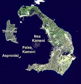
Year- 1600 BC
Total Death- 20000 (Approx.)
Location- Greece
Santorini caldera is a large, mostly submerged caldera, located in the southern Aegean Sea, 120 kilometers north of Crete in Greece. Visible above water is the circular Santorini island group, consisting of Santorini (classic Greek Thera), the main island, Therasia and Aspronisi at the periphery, and the Kameni islands at the center. It has been designated a Decade Volcano.
Read More About Santorini / Source

Mount Samalas

Year- 1257
Total Death- 15000-20000
Location- Indonesia
Read More About Mount Samalas / Source
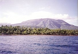
Mount Unzen
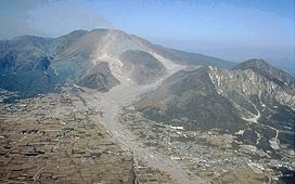
Year- 1792
Total Death- 15000
Location- Japan
Mount Unzen (雲仙岳, Unzen-dake) is an active volcanic group of several overlapping stratovolcanoes, near the city of Shimabara, Nagasaki on the island of Kyushu, Japan’s southernmost main island.
In 1792, the collapse of one of its several lava domes triggered a megatsunami that killed 14,524 people in Japan’s worst volcanic-related disaster. The volcano was most recently active from 1990 to 1995, and a large eruption in 1991 generated a pyroclastic flow that killed 43 people, including three volcanologists.
Its highest peaks are Fugen-dake (普賢岳) at 1,359 metres (4,459 ft) and Heisei-shinzan (平成新山) at 1,486 metres (4,875 ft). The latter emerged during the eruptions of the early, eponymous Heisei era (1989–2019).
Read More About Mount Unzen / Source
Mount Vesuvius
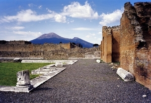
Year- 79 AD
Total Death- 13000+ (Estimated)
Location- Italy
Mount Vesuvius ( viss-OO-vee-əs; Italian: Vesuvio [veˈzuːvjo, -ˈsuː-]; Neapolitan: ‘O Vesuvio [o vəˈsuːvjə], also ‘A muntagna or ‘A montagna; Latin: Vesuvius [wɛˈsʊwɪ.ʊs], also Vesevius, Vesvius or Vesbius) is a somma-stratovolcano located on the Gulf of Naples in Campania, Italy, about 9 km (5.6 mi) east of Naples and a short distance from the shore. It is one of several volcanoes forming the Campanian volcanic arc. Vesuvius consists of a large cone partially encircled by the steep rim of a summit caldera, resulting from the collapse of an earlier, much higher structure.
The eruption of Mount Vesuvius in AD 79 destroyed the Roman cities of Pompeii, Herculaneum, Oplontis, Stabiae, and several other settlements. The eruption ejected a cloud of stones, ashes and volcanic gases to a height of 33 km (21 mi), erupting molten rock and pulverized pumice at the rate of 6×10⁵ cubic metres (7.8×10⁵ cu yd) per second. More than 1,000 people are thought to have died in the eruption, though the exact toll is unknown. The only surviving eyewitness account of the event consists of two letters by Pliny the Younger to the historian Tacitus.Vesuvius has erupted many times since. It is the only volcano on Europe’s mainland to have erupted in the last hundred years. It is regarded as one of the most dangerous volcanoes in the world because 3,000,000 people live near enough to be affected by an eruption, with 600,000 in the danger zone. This is the most densely populated volcanic region in the world. Eruptions tend to be violent and explosive; these are known as Plinian eruptions.
Read More About Mount Vesuvius / Source
Laki
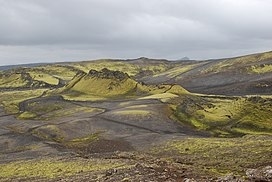
Year- 1783
Total Death- 10000+
Location- Iceland
Laki (Icelandic pronunciation: [ˈlaːcɪ]) or Lakagígar ([ˈlaːkaˌciːɣar̥], Craters of Laki) is a volcanic fissure in the western part of Vatnajökull National Park, Iceland, not far from the volcanic fissure of Eldgjá and the small village of Kirkjubæjarklaustur. The fissure is properly referred to as Lakagígar, while Laki is a mountain that the fissure bisects. Lakagígar is part of a volcanic system centered on the volcano Grímsvötn and including the volcano Þórðarhyrna. It lies between the glaciers of Mýrdalsjökull and Vatnajökull, in an area of fissures that run in a southwest to northeast direction.
The system erupted violently over an eight-month period between June 1783 and February 1784 from the Laki fissure and the adjoining volcano Grímsvötn, pouring out an estimated 42 billion tonnes or 14 km3 (18×10^9 cu yd) of basalt lava and clouds of poisonous hydrofluoric acid and sulfur dioxide compounds that contaminated the soil, leading to the death of over 50% of Iceland’s livestock population, and the destruction of the vast majority of all crops. This led to a famine which then killed approximately a quarter of the island’s human population.The Laki eruption and its aftermath caused a drop in global temperatures, as 120 million tonnes of sulfur dioxide was spewed into the Northern Hemisphere. This caused crop failures in Europe and may have caused droughts in North Africa and India.
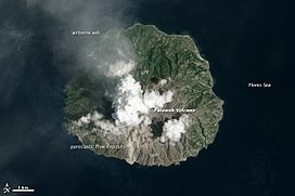
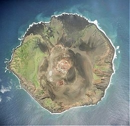
Kelud
Year- 1586
Total Death- 10000
Location- Indonesia
The Kelud (Javanese: ꦏꦼꦭꦸꦢ꧀, romanized: Kelud, sometimes spelled as Klut, Cloot, Kloet, Kloete, Keloed or Kelut) is an active stratovolcano located in Kediri, East Java, Indonesia. Like many Indonesian volcanoes and others on the Pacific Ring of Fire, Kelud is known for large explosive eruptions throughout its history. More than 30 eruptions have occurred since 1000 AD. In 2007, an effusive explosion filled the crater with a lava dome. It last erupted on 13 February 2014, destroying the lava dome and ejecting boulders, stones and ashes up to West Java about 500 kilometres (310 mi) from Mount Kelud. The crater filled with water during the rainy season.
Read More About Kelud / Source
Santa María
Year- 1902
Total Death- 6000
Location- Guatemala
Santa María Volcano is a large active volcano in the western highlands of Guatemala, in the Quetzaltenango Department near the city of Quetzaltenango.
The volcano was known as Gagxanul in the local K’iche’ language, which means “Naked Volcano or Mountain”, before the 16th century Spanish conquest of the region.The VEI-6 eruption of Santa María Volcano in 1902 was one of the three largest eruptions of the 20th century, after the 1912 Novarupta and 1991 Mount Pinatubo eruptions. It is also one of the five biggest eruptions of the past 200 (and most likely 300) years.
Read More About Santa María / Source

Mount Galunggung
Year- 1822
Total Death- 4011
Location- Indonesia
Mount Galunggung (Indonesian: Gunung Galunggung, formerly spelled Galoen-gong) is an active stratovolcano in West Java, Indonesia, around 80 km (50 mi) southeast of the West Java provincial capital, Bandung (or around 25 km (16 mi) to the east of the West Java town of Tasikmalaya). Mount Galunggung is part of the Sunda Arc extending through Sumatra, Java and the Lesser Sunda Islands, which has resulted from the subduction of the Australian plate beneath the Eurasian plate.
For the first time since 1982 after eruptions finished and conditions seemed normal, on February 12, 2012, the status was upgraded to Alert based on changes in conditions.
On 28 May 2012, it was lowered from 2 back to 1 (On a scale of 1–4).
Read More About Mount Galunggung / Source
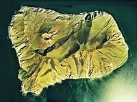
Ritter Island
Year- 1888
Total Death- 3000
Location- Papua New Guinea
Ritter Island is a small crescent-shaped volcanic island 100 kilometres (62 mi) north-east of New Guinea, situated between Umboi Island and Sakar Island.
There are several recorded eruptions of this basaltic-andesitic stratovolcano prior to a spectacular lateral collapse which took place in 1888. Before that event, it was a circular conical island about 780 metres (2,560 ft) high.
Read More About Ritter Island / Source
Mount Papandayan
Year- 1772
Total Death- 2957
Location- Indonesia
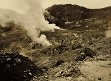
Mount Papandayan is a complex stratovolcano, located in Garut Regency, to the southeast of the city of Bandung in West Java, Indonesia. It is about 15 kilometres (9.3 mi) to the southwest of the town of Garut. At the summit, there are four large craters which contain active fumarole fields. An eruption in 1772 caused the northeast flank to collapse producing a catastrophic debris avalanche that destroyed 40 villages and killed nearly 3,000 people. The eruption truncated the volcano into a broad shape with two peaks and a flat area 1.1 km wide with Alun-Alun crater in the middle, making the mountain appear as a twin volcano; one of the peaks is called Papandayan and the other Mount Puntang.Since 1772, only small phreatic eruptions were recorded before an explosive eruption that began in November 2002. More recently, the volcano has been quite active. On 13 August 2011 the volcano’s early warning status was lifted from Level II, “Vigilant” (Indonesian: Waspada) to Level III, “Alert” (Siaga) following the swarm of long-period events, the increase of volcano tectonic earthquake rate, and an extremely high percentage (100%) of measured carbon dioxide gas in the ground at the summit crater. People, including tourists, were urged to remain at least 2 kilometres (1.2 mi) from the yellow craters on the 2,665-metre-high (8,743 ft) Mount Papandayan. On Friday 2 September 2011, the Indonesian Volcanology and Geophysical Disaster Mitigation Center reported that numerous shallow volcanic earthquakes had been recorded along with other indications of volcanic activity. A spokesperson for the Indonesian National Disaster Management Agency noted that if Mt Papandayan erupted, over 170,000 people living in five nearby subdistricts (kecamatan) and in twenty villages could be affected. Of the people likely to be affected, it was expected that perhaps as many as 11,500 people might need to be evacuated.
Read More About Mount Papandayan / Source
Mount Lamington
Year- 1951
Total Death- 2942
Location- Papua New Guinea
Mount Lamington is an andesitic stratovolcano in the Oro Province of Papua New Guinea. The forested peak of the volcano had not been recognised as such until its devastating eruption in 1951 that caused about 3,000 deaths.The volcano rises to 1680 meters above the coastal plain north of the Owen Stanley Range. A summit complex of lava domes and crater remnants rises above a low-angle base of volcaniclastic deposits that are dissected by radial valleys. A prominent broad “avalanche valley” extends northward from the breached crater.The mountain was named after Charles Cochrane-Baillie, 2nd Baron Lamington who was Governor of Queensland.
Read More About Mount Lamington / Source
Mount Awu

Year- 1856
Total Death- 2806
Location- Indonesia
Mount Awu (Indonesian: Gunung Awu) is the largest volcano in the Sangihe chain, located on Sangir Island in North Sulawesi, Indonesia. Powerful eruptions occurred in 1711, 1812, 1856, 1892 and 1966 with devastating pyroclastic flows and lahars that have resulted in more than 8,000 fatalities altogether. A 4.5 km wide crater is found at the summit and a deep valley forms a passageway for lahars, splitting the flanks from the crater. This is a volcano in the Ring of Fire.
Read More About Mount Awu / Source
Oshima
Year- 1741
Total Death- 2033
Location- Japan
Ōshima (大島) (means “big island”) is an uninhabited island in the Sea of Japan, 50 kilometers (31 mi) to the west from Matsumae town and therefore the westernmost point of Hokkaido. It is part of the town of Matsumae in Oshima Subprefecture in Hokkaido, Japan. To distinguish Ōshima from other islands with the same name, it is sometimes known as Oshima Ōshima (渡島大島) or Matsumae Ōshima (松前大島).
At 9.73 square kilometers (3.76 sq mi), Ōshima is the largest uninhabited island under Japanese sovereignty. The island is a double caldera with a scoria hill rising in the middle. It is the peak of two overlapping stratovolcanoes and their associated calderas, Mount Higashi and Mount Nishi. The highest peak, Mount Era (江良岳, Era-dake) at 737 meters (2,418 ft), is part of a triple volcano. The peak rises close to 2,000 meters (6,600 ft) from the sea floor. The island consists of mafic alkali and non-alkali volcanic rock, less than 18,000 years old.On the south side of the island at Aidomari (北風泊, Aidomari), there is a lighthouse and a heliport operated by Japan Coast Guard.
Because of volcanic activity and nature conservation, landing on the island requires the approval of the Agency for Cultural Affairs.
Read More About Oshima / Source
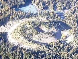
Tseax Cone
Year- 2000
Total Death- 1700
Location- Canada
The Tseax Cone ( SEE-aks), also called the Tseax River Cone or the Aiyansh Volcano, is a young and active cinder cone and adjacent lava flows associated with the Nass Ranges and the Northern Cordilleran Volcanic Province. It is located east of Crater Creek at outlet of Melita Lake, southeast of Gitlakdamix and 60 kilometres (37 mi) north of Terrace, British Columbia, Canada.
The volcano is in a valley above and east of the Tseax River, about 20 kilometres (12 mi) south of the river’s junction with the larger Nass River. The Tseax Cone is one of the most accessible volcanic centres in British Columbia.
Read More About Tseax Cone / Source
El Chichón
Year- 1982
Total Death- 1900
Location- Mexico
El Chichón, also known as Chichonal, is an active volcano in Francisco León, north-western Chiapas, Mexico. El Chichón is part of a geologic zone known as the Chiapanecan Volcanic Arc. El Chichón is a complex of domes with a tuff ring, made of ejected volcanic material, located between the Trans-Mexican Volcanic Belt and the Central America Volcanic Arc. El Chichón erupted in 1982; prior to this, activity had not occurred since c.1360, although debates in literature occur around an eruption occurring in c.1850.El Chichón became famous for its 1982 eruption. In little under a week, the presumed dormant volcano produced three plinian eruptions (March 29, April 3, and April 4). The eruptions released a substantial amount of sulfur dioxide and particulates into the atmosphere. While the total volume of the eruption was much smaller than the famous eruption of Pinatubo in 1991, El Chichón’s impacts were equally significant on global climate. El Chichón is often overlooked in comparison to other historic eruptions, yet the 1982 eruptions provide important lessons on preparation for volcanic disasters and the influence volcanoes can have on climate.
Read More About El Chichón / Source
Soufrière
Year- 1902
Total Death- 1700
Location- St. Vincent
La Soufrière or Soufrière Saint Vincent (French pronunciation: [sufʁjɛʁ sɛ̃ vɛ̃sɑ̃]) is an active stratovolcano on the Caribbean island of Saint Vincent in Saint Vincent and the Grenadines. It is the highest peak in Saint Vincent, and has had five recorded explosive eruptions since 1718. The latest eruptive activity began on 27 December 2020 with the slow extrusion of a dome of lava, and culminated in a series of explosive events between 9 and 22 April 2021.
Read More About Soufrière / Source

Mount Agung

Year- 1963
Total Death- 1584
Location- Indonesia
Mount Agung (Indonesian: Gunung Agung; Balinese: ᬕᬸᬦᬸᬂᬅᬕᬸᬂ) is an active volcano in Bali, Indonesia, southeast of Mount Batur volcano, also in Bali. It is the highest point on Bali, and dominates the surrounding area, influencing the climate, especially rainfall patterns. From a distance, the mountain appears to be perfectly conical. From the peak of the mountain, it is possible to see the peak of Mount Rinjani on the nearby island of Lombok, to the east, although both mountains are frequently covered in clouds. Agung is a stratovolcano, with a large and deep crater. Its most recent eruptions occurred from 2017–2019.
Read More About Mount Agung / Source
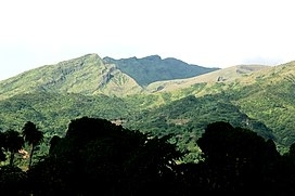
Huaynaputina
Year- 1600
Total Death- 1500
Location- Peru
Huaynaputina ( WY-nə-puu-TEE-nə; Spanish: [wajnapuˈtina]) is a volcano in a volcanic high plateau in southern Peru. Lying in the Central Volcanic Zone of the Andes, it was formed by the subduction of the oceanic Nazca Plate under the continental South American Plate. Huaynaputina is a large volcanic crater, lacking an identifiable mountain profile, with an outer stratovolcano and three younger volcanic vents within an amphitheatre-shaped structure that is either a former caldera or a remnant of glacial erosion. The volcano has erupted dacitic magma.
In the Holocene, Huaynaputina has erupted several times, including on 19 February 1600 – the largest eruption ever recorded in South America – which continued with a series of events into March. Witnessed by people in the city of Arequipa, it killed at least 1,000–1,500 people in the region, wiped out vegetation, buried the surrounding area with 2 metres (7 ft) of volcanic rock and damaged infrastructure and economic resources. The eruption had a significant impact on Earth’s climate, causing a volcanic winter: temperatures in the Northern Hemisphere decreased; cold waves hit parts of Europe, Asia and the Americas; and the climate disruption may have played a role in the onset of the Little Ice Age. Floods, famines, and social upheavals resulted. This eruption has been computed to measure 6 on the Volcanic Explosivity Index (VEI).
The volcano has not erupted since 1600. There are fumaroles in the amphitheatre-shaped structure, and hot springs occur in the region, some of which have been associated with Huaynaputina. The volcano lies in a remote region where there is little human activity, but about 30,000 people live in the immediately surrounding area, and another one million in the Arequipa metropolitan area. If an eruption similar to the 1600 event were to occur, it would quite likely lead to a high death toll and cause substantial socioeconomic disruption. The Peruvian Geophysical Institute announced in 2017 that Huaynaputina would be monitored by the Southern Volcanological Observatory, and seismic observation began in 2019.
Read More About Huaynaputina / Source
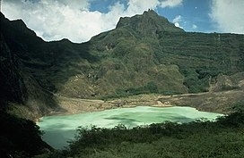
Mount Merapi
Year- 1930
Total Death- 1369
Location- Indonesia
Mount Merapi, Gunung Merapi (literally Fire Mountain in Indonesian and Javanese), is an active stratovolcano located on the border between the province of Central Java and the Special Region of Yogyakarta, Indonesia. It is the most active volcano in Indonesia and has erupted regularly since 1548. It is located approximately 28 km (17 mi) north of Yogyakarta city which has a population of 2.4 million, and thousands of people live on the flanks of the volcano, with villages as high as 1,700 m (5,577 ft) above sea level.
Smoke can often be seen emerging from the mountaintop, and several eruptions have caused fatalities. A pyroclastic flow from a large explosion killed 27 people on 22 November 1994, mostly in the town of Muntilan, west of the volcano. Another large eruption occurred in 2006, shortly before the Yogyakarta earthquake. In light of the hazards that Merapi poses to populated areas, it was designated as one of the Decade Volcanoes.
On the afternoon of 25 October 2010, Merapi erupted on its southern and southeastern slopes. A total of 353 people were killed over the next month, while 350,000 were forced to flee their homes; most of the damage was done by pyroclastic flows, while heavy rain on 4 November created lahars which caused further damage. Most of the fissures had ceased erupting by 30 November, and four days later the official threat level was lowered. Merapi’s characteristic shape was changed during the eruptions, with its height lowered 38 m (125 ft) to 2,930 m (9,613 ft).Since 2010, Merapi had experienced several smaller eruptions, most noticeably two phreatic eruptions which occurred on 18 November 2013 and 11 May 2018. The first and larger of these, caused by a combination of rainfall and internal activity, saw smoke issued up to a height of 2,000 m (6,562 ft). There have been several small eruptions since the beginning of 2020, which are of great interest to volcanologists.
Read More About Mount Merapi / Source
Taal
Year- 1911
Total Death- 1335
Location- Philippines
Taal Volcano (IPA: [taʔal]; Tagalog: Bulkang Taal) is a large caldera filled by Taal Lake in the Philippines. Located in the province of Batangas, the volcano is second of the most active volcanoes in the country, with 38 recorded historical eruptions, all of which were concentrated on Volcano Island, near the middle of Taal Lake. The caldera was formed by prehistoric eruptions between 140,000 and 5,380 BP.The volcano is located about 50 kilometers (31 mi) south of Manila, the capital of the Philippines.
Taal Volcano has had several violent eruptions in the past, causing deaths on the island and the populated areas surrounding the lake, with an overall death toll of about 6,000. Because of its proximity to populated areas and its eruptive history, the volcano was designated a Decade Volcano, worthy of close study to prevent future natural disasters. All volcanoes in the Philippines are part of the Ring of Fire.
Gamalama
Year- 1775
Total Death- 1300
Location- Indonesia
Gamalama is a near-conical stratovolcano that comprises the entire Ternate island in Indonesia. The island lies off the western shore of Halmahera island in the north of the Maluku Islands. For centuries, Ternate was a center of Portuguese and Dutch forts for spice trade, which have accounted for thorough reports of Gamalama’s volcanic activities.
An eruption in 1775 caused the deaths of approximately 1300 people.On December 4, 2011 Mount Gamalama erupted, ejecting material up to 2,000 meters into the air. Thousands of residents in nearby Ternate City fled due to ash and dust particles raining down on the town. Finally on December 27 some 4 people died and dozens injured from debris falls (lahar) after a month of activity.More eruptions occurred in September 2012.An eruption on December 18, 2014, deposited five centimeters of ash on the runway of Babullah Airport in Ternate, closing the airport.
Read More About Gamalama / Source
Mount Mayon

Year- 1814
Total Death- 1200
Location- Philippines
Mayon (Central Bikol: Bulkan Mayon; Tagalog: Bulkang Mayon, IPA: [mɐjɔn]), also known as Mount Mayon and Mayon Volcano (Spanish: Monte Mayón, Volcán Mayón), is an active stratovolcano in the province of Albay in Bicol, Philippines. A popular tourist spot, it is renowned for its “perfect cone” because of its symmetric conical shape, and is regarded as very sacred in Philippine mythology.The volcano with its surrounding landscape was declared a national park on July 20, 1938, the first in the nation. It was reclassified as a natural park and renamed the Mayon Volcano Natural Park in 2000. It is the centerpiece of the Albay Biosphere Reserve, declared by UNESCO in 2016, and is currently being nominated as a World Heritage Site.
Mayon is the most active volcano in the Philippines, and its activity is regularly monitored by the Philippine Institute of Volcanology and Seismology (PHIVOLCS) from their provincial headquarters on Ligñon Hill, about 12 kilometers (7.5 mi) from the summit.
Read More About Mount Mayon / Source
Mount Asama
Year- 1783
Total Death- 1151
Location- Japan
Mount Asama (浅間山, Asama-yama) is an active complex volcano in central Honshū, the main island of Japan. The volcano is the most active on Honshū. The Japan Meteorological Agency classifies Mount Asama as rank A. It stands 2,568 metres (8,425 ft) above sea level on the border of Gunma and Nagano prefectures. It is included in 100 Famous Japanese Mountains.
Read More About Mount Asama / Source
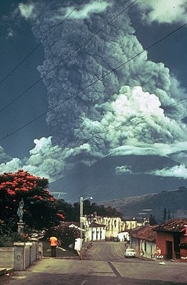
Mount Pinatubo
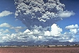
Year- 1991
Total Death- 847
Location- Philippines
Mount Pinatubo is an active stratovolcano in the Zambales Mountains, located on the tripoint boundary of the Philippine provinces of Zambales, Tarlac and Pampanga, all in Central Luzon on the northern island of Luzon. Its eruptive history was unknown to most before the pre-eruption volcanic activity of early 1991. Pinatubo was heavily eroded and obscured from view by dense forests which supported a population of several thousand indigenous Aetas.
Pinatubo is most notorious for its VEI-6 eruption on June 15, 1991, the second-largest terrestrial eruption of the 20th century after the 1912 eruption of Novarupta in Alaska.
Complicating the eruption was the arrival of Typhoon Yunya, bringing a lethal mix of ash and rain to towns and cities surrounding the volcano. Predictions at the onset of the climactic eruption led to the evacuation of tens of thousands of people from the surrounding areas, saving many lives. Surrounding areas were severely damaged by pyroclastic surges, pyroclastic falls, and subsequently, by the flooding lahars caused by rainwater re-mobilizing earlier volcanic deposits. This caused extensive destruction to infrastructure and changed river systems for years after the eruption. Minor dome-forming eruptions inside the caldera continued from 1992 to 1993.
The effects of the 1991 eruption were felt worldwide. It erupted roughly 10 billion tonnes (1.1×10¹⁰ short tons) or 10 km3 (2.4 cu mi) of magma, and 20 million tonnes (22 million short tons) of SO2, bringing vast quantities of minerals and toxic metals to the surface environment. It ejected more particulate into the stratosphere than any eruption since Krakatoa in 1883. Over the following months, the aerosols formed a global layer of sulfuric acid haze. Global temperatures dropped by about 0.5 °C (0.9 °F) in the years 1991–1993, and ozone depletion temporarily saw a substantial increase.
Read More About Mount Pinatubo / Source
Hokkaido Komagatake
Year- 1640
Total Death- 700
Location- Japan
Hokkaidō Koma-ga-take (北海道駒ヶ岳, Hokkaidō Koma-ga-take), also Oshima Koma-ga-take (渡島駒ヶ岳), Oshima Fuji (渡島富士), or just Koma-ga-take (駒ヶ岳) is a 1,131 metres (3,711 ft) andesitic stratovolcano on the border between Mori, Shikabe, and Nanae, all within the Oshima Subprefecture of Hokkaidō, Japan.
Occurrence of volcanic activity started some 30,000 years ago. Following roughly 5,000 years of dormancy, volcanic activity at Mount Koma-ga-take restarted at the start of the 17th century, triggering the Kan’ei Great Famine in 1640. Since then, there have been at least 50 recorded volcanic events at Mount Koma-ga-take.
Read More About Hokkaido Komagatake / Source
Rabaul
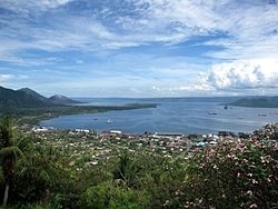
Year- 1937
Total Death- 507
Location- Papua New Guinea
Rabaul is a township in the East New Britain province of Papua New Guinea, on the island of New Britain. It lies about 600 kilometres to the east of the island of New Guinea. Rabaul was the provincial capital and most important settlement in the province until it was destroyed in 1994 by falling ash from a volcanic eruption in its harbour. During the eruption, ash was sent thousands of metres into the air, and the subsequent rain of ash caused 80% of the buildings in Rabaul to collapse. After the eruption the capital was moved to Kokopo, about 20 kilometres (12 mi) away. Rabaul is continually threatened by volcanic activity, because it is on the edge of the Rabaul caldera, a flooded caldera of a large pyroclastic shield.
Rabaul was planned and built around the harbour area known as Simpsonhafen (Simpson Harbour) during the German New Guinea administration, which controlled the region between 1884 and formally through 1919. Rabaul was selected as the capital of the German New Guinea administration in 1905, and the administrative offices were transferred there in 1910. Rabaul was captured by the British Empire during the early days of World War I. It became the capital of the Australian-mandated Territory of New Guinea until 1937, when it was first destroyed by a volcano. During World War II, it was captured by Japan in 1942 and became its main base of military and naval activity in the South Pacific. Settlements and military installations around the edge of the caldera are often collectively called Rabaul, although the old town of Rabaul was reduced to practical insignificance by the volcanic eruption in 1937.
As a tourist destination, Rabaul is popular for its volcanoes, scuba diving and for snorkelling sites, spectacular harbour and other scenery, World War II history, flora and fauna, and the cultural life of the Tolai people. Before the 1994 eruption, Rabaul was a popular commercial and recreational boating destination; fewer private small craft visit now, but 10 to 12 cruise ships visit Rabaul each year, including the Queen Elizabeth, carrying up to 2,000 passengers. Tourism is a major industry in Rabaul and East New Britain generally.
Read More About Rabaul / Source
Hibok-Hibok
Year- 1951
Total Death- 500
Location- Philippines
Mount Hibok-Hibok (also known as Catarman Volcano) is a stratovolcano on Camiguin Island in the Philippines. It is one of the active volcanoes in the country and part of the Pacific ring of fire.
Read More About Hibok-Hibok / Source
Mount Bandai
Mount Bandai (磐梯山, Bandai-san) is a stratovolcano located in Inawashiro-town, Bandai-town, and Kitashiobara village, in Yama-Gun, Fukushima prefecture. It is an active stratovolcano located to the north of Lake Inawashiro. Mount Bandai, including the Bandai heights, belongs to the Bandai-Asahi National Park.
The altitude of the triangulation station “Bandai”, installed in 1904, had been employed as the official altitude of Mount Bandai. However, after the station disappeared due to erosion, it was re-measured in October 2010 and now is 1,816.29m. The name “Mount Bandai” is used to refer to the main peak “Bandai”, along with several other peaks including Akahani at 1,430m and Kushigamine at 1,636m, created during the 1888 eruption of Mount Bandai.
Mount Bandai was originally called “Iwahashi-yama” which means “a rock ladder to the sky”. It is now sometimes called “Aizu Fuji” and “Aizu Bandai”. The south foot is called Omotebandai and the north foot is called Urabandai. When seen from Omotebandai, the mountain looks very tidy, but when viewed from Urabandai the mountain shows a wild shape, due to its collapse.
It is one of the list of the 100 famous mountains in Japan. In 2007, the mountain was selected as one of the top 100 geographic landmarks in Japan. Additionally, in 2011 the mountain was certified as a geopark of Japan.
Read More About Mount Bandai / Source
Anak Krakatoa
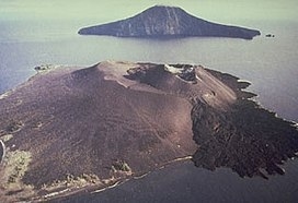
Anak Krakatoa (Indonesian: Anak Krakatau) is a volcanic island in Indonesia. On 29 December 1927, Anak Krakatoa first emerged from the caldera formed in 1883 by the explosive volcanic eruption that destroyed the island of Krakatoa. There has been sporadic eruptive activity at the site since the late 20th century, culminating with a large underwater collapse of the volcano that caused a deadly Tsunami in December 2018. There has been subsequent activity since. Due to its young age, the island is one of several in the area that are of interest to, and the subject of extensive study by, volcanologists.
Read More About Anak Krakatoa / Source
Ruang

Ruang is the southernmost stratovolcano in the Sangihe Islands arc. It comprises an island 4 × 5 km wide. The summit contains a partial lava dome, and reaches some 2,379 ft in altitude. From its summit, Klabat’s peak in the south, that of Siau to the north, and Ternate to the east can all be seen.
Read More About Ruang / Source
Kilauea
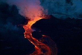
Kīlauea (US: KIL-ə-WAY-ə, Hawaiian: [kiːlɐwˈwɛjə]) is an active shield volcano in the Hawaiian Islands. Located along the southeastern shore of the Big Island of Hawaiʻi, the volcano is between 210,000 and 280,000 years old and emerged above sea level about 100,000 years ago. Historically, it is the most active of the five volcanoes that together form Hawaii island. Kīlauea is also one of the most active volcanoes on Earth, and the most recent and currently ongoing eruption began on September 29, 2021, when several vents began to erupt lava within Halemaʻumaʻu, a pit crater in the volcano’s summit caldera.
Kīlauea is the second-youngest product of the Hawaiian hotspot and the current eruptive center of the Hawaiian–Emperor seamount chain. Because it lacks topographic prominence and its activities historically coincided with those of Mauna Loa, Kīlauea was once thought to be a satellite of its much larger neighbor. Structurally, Kīlauea has a large, fairly recently formed caldera at its summit and two active rift zones, one extending 125 km (78 mi) east and the other 35 km (22 mi) west, as an active fault of unknown depth moving vertically an average of 2 to 20 mm (0.1 to 0.8 in) per year.
Between 2008 and 2018, the pit crater Halemaʻumaʻu hosted an active lava lake. Kīlauea also erupted nearly continuously from vents on its eastern rift zone between January 1983 and April 2018, causing considerable property damage, including the destruction of the towns of Kalapana and Kaimū along with the community’s renowned black sand beach, in 1990.
Beginning in May 2018, activity shifted further downrift from the summit to the lower Puna district, during which lava erupted from two dozen vents. The eruption saw vigorous eruptive lava fountains that sent destructive rivers of molten rock into the ocean in three places. The eruption destroyed Hawaii’s largest natural freshwater lake, covered substantial portions of Leilani Estates and Lanipuna Gardens, and completely inundated the communities of Kapoho, Vacationland Hawaii, and most of the Kapoho Beach Lots. Lava also filled Kapoho Bay and extended new land nearly a mile into the sea. The County of Hawaii reported that 716 dwellings were destroyed by lava. Concurrent with the activity downrift in lower Puna, the lava lake within Halemaʻumaʻu drained and a series of explosive collapse events occurred at the volcano’s summit, with at least one explosion emitting ash 30,000 feet (9,100 m) into the air. This activity prompted a months-long closure of the Kīlauea section of Hawaii Volcanoes National Park. The eruption ended in September 2018. After more than two years of quiescence, Kīlauea erupted again between December 2020 and May 2021 within Halemaʻumaʻu crater, where lava erupting from several vents boiled off a water lake that had been growing within the crater for more than a year, replacing it with a lava lake 229 metres (751 ft) deep.
Read More About Kilauea / Source
Makian
Makian (also Machian), known to local people as Mount Kie Besi, is a volcanic island, one of the Maluku Islands within the province of North Maluku in Indonesia. It lies near the southern end of a chain of volcanic islands off the western coast of the province’s major island, Halmahera, and lies between the islands of Moti and Tidore to the north and Kayoa and the Bacan Group to the south. The island, which forms two districts (Pulau Makian and Makian Barat) within South Halmahera Regency of North Maluku Province, covers an area of 84.36 sq.km, and had a population of 12,394 at the 2010 Census, which rose to 14,000 at the 2020 Census.The island is 10 kilometres (6 miles) wide, and its 1,357-metre (4,452-foot) high summit consists of a large 1.5 kilometres (1 mile) wide crater, with a small lake on its Northeast side. There are four parasitic cones on the western slopes of Makian. Makian volcano is also known as Mount Kiebesi (or Kie Besi).
Read More About Makian / Source
Nyiragongo

Mount Nyiragongo ( neer-ə-GONG-go) is an active stratovolcano with an elevation of 3,470 m (11,385 ft) in the Virunga Mountains associated with the Albertine Rift. It is located inside Virunga National Park, in the Democratic Republic of the Congo, about 12 km (7.5 mi) north of the town of Goma and Lake Kivu and just west of the border with Rwanda. The main crater is about two kilometres (1 mi) wide and usually contains a lava lake. The crater presently has two distinct cooled lava benches within the crater walls – one at about 3,175 m (10,417 ft) and a lower one at about 2,975 m (9,760 ft).
Nyiragongo’s lava lake has at times been the most voluminous known lava lake in recent history. The depth of the lava lake varies considerably. A maximum elevation of the lava lake was recorded at about 3,250 m (10,660 ft) prior to the January 1977 eruption – a lake depth of about 600 m (2,000 ft). Following the January 2002 eruption, the lava lake was recorded at a low of about 2,600 m (8,500 ft), or 900 m (3,000 ft) below the rim. The level has gradually risen since then. Nyiragongo and nearby Nyamuragira are together responsible for 40 per cent of Africa’s historical volcanic eruptions.
Read More About Nyiragongo / Source
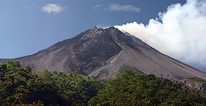
Volcán de Fuego
Volcán de Fuego (Spanish pronunciation: [bolˈkan de ˈfweɣo]; Spanish for “Volcano of Fire”, often shortened to Fuego) or Chi Q’aq’ (Kaqchikel for “where the fire is”) is an active stratovolcano in Guatemala, on the borders of Chimaltenango, Escuintla and Sacatepéquez departments. It sits about 16 kilometres (9.9 mi) west of Antigua, one of Guatemala’s most famous cities and a tourist destination. It has erupted frequently since the Spanish conquest, most recently in June and November 2018, 23 September 2021, and 11 December 2022.Fuego is famous for being almost constantly active at a low level. Small gas and ash eruptions occur every 15 to 20 minutes, but larger eruptions are rare. Andesite and basalt lava types dominate, and recent eruptions have tended to be more mafic than older ones.The volcano is joined with Acatenango and collectively the complex is known as La Horqueta.
Read More About Volcán de Fuego / Source
Paluweh
Paluweh, also known as Rokatenda, is a stratovolcano that forms the small island of Palu’e, north of Flores Island in Sikka Regency in the province of East Nusa Tenggara, Indonesia. While the volcano rises about 3,000 m (9,840 ft) above the sea floor, its cone rises just 875 metres (2,871 ft) above sea level and is the highest point on the island.The broad summit region contains overlapping craters up to 900 m (2,950 ft) wide along with several lava domes. Several flank vents occur along a northwest trending fissure.
Read More About Paluweh / Source
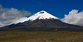
Mount Ruapehu

Mount Ruapehu (; Māori: [ˈɾʉaˌpɛhʉ]) is an active stratovolcano at the southern end of the Taupō Volcanic Zone and North Island volcanic plateau in New Zealand. It is 23 kilometres (14 mi) northeast of Ohakune and 23 km (14 mi) southwest of the southern shore of Lake Taupō, within the Tongariro National Park. The North Island’s major ski resorts and only glaciers are on its slopes.
Ruapehu, the largest active volcano in New Zealand, has the highest point in the North Island and has three major peaks: Tahurangi (2,797 m), Te Heuheu (2,755 m) and Paretetaitonga (2,751 m). The deep, active crater is between the peaks and fills with water between major eruptions, being known as Crater Lake (Māori: Te Wai ā-moe). The name Ruapehu means “pit of noise” or “exploding pit” in Māori.
Read More About Mount Ruapehu / Source
Tori-shima
Tori-shima (Japanese: 鳥島, Hepburn: Tori-shima) ‘Bird Island’, or Izu-Torishima (Japanese: 伊豆鳥島, Hepburn: Izu-Torishima) ‘Bird Island of Izu Province’) is an uninhabited Japanese island in the Pacific Ocean. The volcanic island is part of the Izu Islands.
Read More About Tori-shima / Source
Dieng Volcanic Complex
The Dieng Volcanic Complex (Javanese: ꦢꦶꦲꦾꦁ, romanized: Dihyang) is a volcanic complex located on the Dieng Plateau in the Central Java, Indonesia, a complex of volcanoes. The volcanic complex consists of two or more of stratovolcanoes, more than 20 small craters and Pleistocene-to-Holocene age volcanic cones. It covers over 6 × 14 km area. The Prahu stratovolcano was truncated by a large Pleistocene caldera and then filled by parasitic cones, lava domes and craters which is 120 Celsius. Some of them are turned into lakes. Toxic volcanic gas has caused fatalities and is a hazard at several craters. On 20 February 1979 149 people died of gas poisoning in Pekisaran village on the plateau near the Sinila crater. The area is also home to a major geothermal project.
Read More About Dieng Volcanic Complex / Source
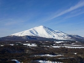
Mount Tokachi
Mount Tokachi (十勝岳, Tokachidake) is an active volcano located in Daisetsuzan National Park, Hokkaidō, Japan. It is the tallest volcano of the Tokachi Volcanic Group, with a height of 2,077 metres (6,814 ft). It is one of the 100 famous mountains in Japan.
There are four hiking trails to the peak of Tokachidake. Below is a hut, a campground and a natural hot spring (onsen).
Read More About Mount Tokachi / Source
Mount Tarawera
Mount Tarawera is a volcano on the North Island of New Zealand within the older but volcanically productive Ōkataina Caldera. Located 24 kilometres southeast of Rotorua, it consists of a series of rhyolitic lava domes that were fissured down the middle by an explosive basaltic eruption in 1886. This eruption was one of New Zealand’s largest historical eruptions, and killed an estimated 120 people. The fissures run for about 17 kilometres (11 mi) northeast-southwest.
The volcano’s component domes include Ruawahia Dome (the highest at 1,111 metres), Tarawera Dome and Wahanga Dome. It is surrounded by several lakes, most of which were created or drastically altered by the 1886 eruption. These lakes include Lakes Tarawera, Rotomahana, Rerewhakaaitu, Ōkataina, Ōkareka, Tikitapu / Blue and Rotokākahi / Green. The Tarawera River runs northeastwards across the northern flank of the mountain from Lake Tarawera. In 2000, the mountain was ceded to the Ngāti Rangitihi sub-tribe of Te Arawa. In 2002, the group and their lessee stopped previously free public access to the mountain. This decision caused angst among Rotorua residents.While the 1886 eruption was basaltic, study has shown there was only a small basalt component to the previous recent rhyolitic predominant eruptions.
Read More About Mount Tarawera / Source
Dubbi
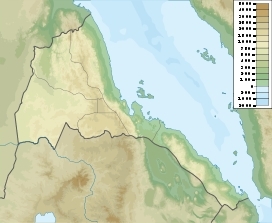
The Dubbi Volcano is a stratovolcano located in the Southern Red Sea Region of Eritrea. Its peak elevation is 1,625 m (5,331 ft). There have been four known eruptions. In 1400 lava was determined to have reached the Red Sea while in 1861 ash was thrown over 250 km (160 mi) from the volcano. Two further events were suspected between 1861 and the 20th century.
On June 13, 2011 an ash cloud that had some influence on air travel was attributed to Dubbi. However, more accurate satellite imagery later showed that Nabro was the volcano that had erupted.
Read More About Dubbi / Source
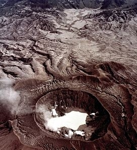
Arenal Volcano
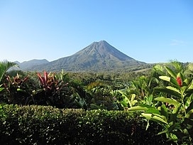
Arenal Volcano (Spanish: Volcán Arenal) is an active andesitic stratovolcano in north-western Costa Rica around 90 km (56 mi) northwest of San José, in the province of Alajuela, canton of San Carlos, and district of La Fortuna. The Arenal volcano measures at least 1,633 metres (5,358 ft) high. It is conically shaped with a crater 140 metres (460 ft) in diameter. Geologically, Arenal is considered a young volcano and it is estimated to be less than 7,500 years old. It is also known as “Pan de Azúcar”, “Canaste”, “Volcan Costa Rica”, “Volcan Río Frío” or “Guatusos Peak”.The volcano was dormant for hundreds of years and exhibited 2 craters at its summit, with minor fumaroles activity, covered by dense vegetation. In 1968 it erupted unexpectedly, destroying the small town of Tabacón. Due to the eruption three more craters were created on the western flanks but only one of them still exists today. Arenal’s eruption from 1968 to 2010 is the tenth longest duration volcanic eruption on Earth since 1750. Since 2010, Arenal has been dormant.
Read More About Arenal Volcano / Source
Mount Marapi

The Marapi (ماراڤي), or Mount Marapi (Minangkabau: ڬونوواڠ ماراڤي, romanized: Gunuang Marapi) is a complex volcano in West Sumatra, Indonesia. Its name means Mountain of Fire, and it is the most active volcano in Sumatra. Its elevation is 2,891.3 metres (9,485.9 ft). A number of cities and towns are situated around the mountain, including Bukittinggi, Padang Panjang and Batusangkar.
According to legend, the mountain is the site first settled by the Minangkabau people after their ship landed on the mountain when it was the size of an egg and surrounded by water. There are large numbers of upright burial stones in the region which are oriented in the direction of the mountain, indicating its cultural significance.
Read More About Mount Marapi / Source
Kolumbo

Kolumbo is an active submarine volcano in the Aegean Sea in Greece, about 8 km northeast of Cape Kolumbo, Santorini island. The largest of a line of about twenty submarine volcanic cones extending to the northeast from Santorini, it is about 3 km in diameter with a crater 1.5 km across. It was “discovered” when it breached the sea surface in 1649-50, but its explosion was not to be compared to the well-known Thera explosion and caldera collapse, currently dated ca. 1630 BCE, with its devastating consequences for Minoan civilization. The Smithsonian Institution’s Global Volcanism Program treats it as part of the Santorini volcano, though at least one source maintains that it is a separate magmatic system.The 1650 explosion, which occurred when the accumulating cone reached the surface, sent pyroclastic flows across the sea surface to the shores and slopes of Santorini, where about seventy people and many animals died. A small ring of white pumice that formed was rapidly eroded away by wave action. The volcano collapsed into its caldera, triggering a tsunami that caused damage on nearby islands up to 150 km distant. The highest parts of the crater rim are now about 10 m below sea level.
In 2006, sea floor pyroclastic deposits from the two Aegean explosions were explored, sampled and mapped by an expedition by NOAA Ocean Explorer, equipped with ROV robotics.
The crater floor, averaging about 505 m below the sea surface, is marked in its northeast area by a field of hydrothermal vents and covered by a thick bacterial community, the 2006 NOAA expedition discovered. Superheated (measured as hot as 224 °C) metal-enriched water issuing from the vents has built chimneys of polymetallic sulfide/sulfates to a maximum height of 4 m, apparently accumulated since the 1650 event.
The 2006 expedition initiated new seismic air-gun techniques in order to determine the volume and distribution of the submarine volcanic deposit of pumice and ash on the sea floor around Santorini, which has been studied extensively since 1975. Revised, more accurate estimates of the total dense rock equivalent volume of the Minoan event(s), consisting of pyroclastic sea floor deposits, distal ash fallout and ignimbrites on the island of Santorini, is likely about 60 km³, a greatly increased estimate, comparable to the largest historic explosion, Mount Tambora 1815; the increased estimate affects the size of the ensuing tsunami as it has been widely modeled.
Read More About Kolumbo / Source
Mount Ontake

Mount Ontake (御嶽山, Ontake-san), also referred to as Mount Kiso Ontake (木曽御嶽山, Kiso Ontake-san), is the 14th highest mountain and second highest volcano in Japan (after Mount Fuji) at 3,067 m (10,062 ft). It is included in 100 Famous Japanese Mountains.
Read More About Mount Ontake / Source
Sakurajima
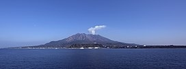
Sakurajima (Japanese: 桜島, literally “Cherry Blossom Island”) is an active stratovolcano, formerly an island and now a peninsula, in Kagoshima Prefecture in Kyushu, Japan. The lava flows of the 1914 eruption connected it with the Ōsumi Peninsula. It is the most active volcano in Japan.As of April 2021, the volcanic activity still continues, dropping volcanic ash on the surroundings. Earlier eruptions built the white sand highlands in the region. On September 13, 2016, a team of experts from Bristol University and the Sakurajima Volcano Research Centre in Japan suggested that the volcano could have a major eruption within 30 years; since then two eruptions have occurred.Sakurajima is a stratovolcano. Its summit has three peaks, Kita-dake (northern peak), Naka-dake (central peak) and Minami-dake (southern peak) which is active now.
Kita-dake is Sakurajima’s highest peak, rising to 1,117 m (3,665 ft) above sea level. The mountain is in a part of Kagoshima Bay known as Kinkō-wan. The former island is part of the city of Kagoshima. The surface of this volcanic peninsula is about 77 km2 (30 sq mi).
Read More About Sakurajima / Source
Semeru
The Semeru (Javanese: ꦱꦼꦩꦺꦫꦸ), or Mount Semeru (Javanese: ꦒꦸꦤꦸꦁꦱꦼꦩꦺꦫꦸ (Pegon:ڮنڠ سمَيرو, romanized: Gunung Semeru), is an active volcano located in East Java, Indonesia. It is located in a subduction zone, where the Indo-Australian plate subducts under the Eurasia plate. It is the highest mountain on the island of Java. The name “Semeru” is derived from Meru, the central world mountain in Hinduism, or Sumeru, the abode of gods. This stratovolcano is also known as Mahameru, meaning “The Great Mountain” in Sanskrit. It is one of the more popular hiking destinations in Indonesia.
Read More About Semeru / Source
Mount St. Helens
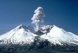
Mount St. Helens (known as Lawetlat’la to the indigenous Cowlitz people, and Loowit or Louwala-Clough to the Klickitat) is an active stratovolcano located in Skamania County, Washington, in the Pacific Northwest region of the United States. It lies 52 miles (83 km) northeast of Portland, Oregon, and 98 miles (158 km) south of Seattle. Mount St. Helens takes its English name from that of the British diplomat Lord St Helens, a friend of explorer George Vancouver who surveyed the area in the late 18th century. The volcano is part of the Cascade Volcanic Arc, a segment of the Pacific Ring of Fire.
The Mount St. Helens major eruption of May 18, 1980 remains the deadliest and most economically destructive volcanic event in U.S. history. Fifty-seven people were killed; 200 homes, 47 bridges, 15 miles (24 km) of railways, and 185 miles (298 km) of highway were destroyed. A massive debris avalanche, triggered by a magnitude 5.1 earthquake, caused a lateral eruption that reduced the elevation of the mountain’s summit from 9,677 ft (2,950 m) to 8,363 ft (2,549 m), leaving a 1 mile (1.6 km) wide horseshoe-shaped crater. The debris avalanche was 0.6 cubic miles (2.5 km3) in volume. The 1980 eruption disrupted terrestrial ecosystems near the volcano. By contrast, aquatic ecosystems in the area greatly benefited from the amounts of ash, allowing life to multiply rapidly. Six years after the eruption, most lakes in the area had returned to their normal state.After its 1980 eruption, the volcano experienced continuous volcanic activity until 2008. Geologists predict that future eruptions will be more destructive, as the configuration of the lava domes require more pressure to erupt. However, Mount St. Helens is a popular hiking spot and it is climbed year-round. In 1982, the Mount St. Helens National Volcanic Monument was established by President Ronald Reagan and the U.S. Congress.
Read More About Mount St. Helens / Source
Mount Etna
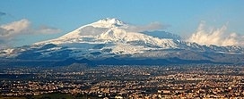
Mount Etna, or simply Etna (Italian: Etna [ˈɛtna] or Mongibello [mondʒiˈbɛllo]; Sicilian: Muncibbeḍḍu [mʊntʃɪbˈbɛɖɖʊ] or a Muntagna; Latin: Aetna; Ancient Greek: Αἴτνα and Αἴτνη), is an active stratovolcano on the east coast of Sicily, Italy, in the Metropolitan City of Catania, between the cities of Messina and Catania. It lies above the convergent plate margin between the African Plate and the Eurasian Plate. It is one of the tallest active volcanoes in Europe, and the tallest peak in Italy south of the Alps with a current height (July 2021) of 3,357 m (11,014 ft), though this varies with summit eruptions. Over a six-month period in 2021, Etna erupted so much volcanic material that its height increased by approximately 100 ft (30 m), and the southeastern crater is now the tallest part of the volcano.Etna covers an area of 1,190 km2 (459 sq mi) with a basal circumference of 140 km (87 miles). This makes it by far the largest of the three active volcanoes in Italy, being about two and a half times the height of the next largest, Mount Vesuvius. Only Mount Teide on Tenerife in the Canary Islands surpasses it in the whole of the European–North-African region west of the Black Sea.In Greek mythology, the deadly monster Typhon was trapped under this mountain by Zeus, the god of the sky and thunder and king of gods, and the forges of Hephaestus were said also to be underneath it.Mount Etna is one of the world’s most active volcanoes and is in an almost constant state of activity. The fertile volcanic soils support extensive agriculture, with vineyards and orchards spread across the lower slopes of the mountain and the broad Plain of Catania to the south. Due to its history of recent activity and nearby population, Mount Etna has been designated a Decade Volcano by the United Nations. In June 2013, it was added to the list of UNESCO World Heritage Sites.
Read More About Mount Etna / Source
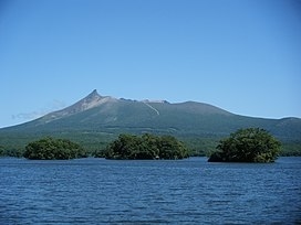
Mount Usu

Mount Usu (有珠山, Usu-zan) is an active stratovolcano in the Shikotsu-Toya National Park, Hokkaido, Japan. It has erupted four times since 1900: in 1910 (which created Meiji-shinzan), 1944–45 (which created Shōwa-shinzan), August 7, 1977, and on March 31, 2001. To the north lies Lake Tōya. Mount Usu formed on the southern rim of the caldera containing the lake.
Mount Usu and Shōwa-shinzan are major tourist attractions in the Shikotsu-Toya National Park. A ropeway on Mount Usu takes visitors to viewing platforms overlooking Shōwa-shinzan. The 1977 eruption is mentioned in passing in Alan Booth’s travelogue, The Roads to Sata. The 2008 G8 Summit was held near Mount Usu at Lake Tōya.
Read More About Mount Usu / Source
Bayonnaise Rocks
Bayonnaise Rocks (ベヨネース列岩, Beyonēsu-retsugan) is a group of volcanic rocks in the Philippine Sea about 408 kilometres (254 mi) south of Tokyo and 65 kilometres (40 mi) south-southeast of Aogashima, in the south portion of the Izu archipelago, Japan. The rocks were discovered by the French corvette Bayonnaise in 1850, while surveying the islands south of Tokyo Bay.
Read More About Bayonnaise Rocks / Source
Nabro Volcano
The Nabro Volcano is an active stratovolcano in the Southern Red Sea Region of Eritrea. It is located at the south-east end of the Danakil Alps in the Danakil Depression. Before its 2011 eruption, the volcano was widely believed to be extinct.
Read More About Nabro Volcano / Source
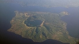
Rinjani

Mount Rinjani (Indonesian: Gunung Rinjani) is an active volcano in Indonesia on the island of Lombok. Administratively the mountain is in the Regency of North Lombok, West Nusa Tenggara (Indonesian: Nusa Tenggara Barat, NTB). It rises to 3,726 metres (12,224 ft), making it the second highest volcano in Indonesia. It is also the highest point in the Indonesian province of West Nusa Tenggara.
Adjacent to the volcano is a 6-by-8.5-kilometre (3.7 by 5.3 mi) caldera, which is filled partially by the crater lake known as Segara Anak or Anak Laut (Child of the Sea), due to the color of its water, as blue as the sea (laut). This lake is approximately 2,000 metres (6,600 ft) above sea level and estimated to be about 200 metres (660 ft) deep; the caldera also contains hot springs. Sasak tribe and Hindu people assume the lake and the mount are sacred and some religious activities are occasionally done in the two areas. UNESCO made Mount Rinjani Caldera a part of the Global Geoparks Network in April 2018.
Read More About Rinjani / Source
Villarrica
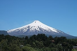
Villarrica ( VEE-ə-REE-kə) (Spanish: Volcán Villarrica, Mapudungun: Ruka Pillañ) is one of Chile’s most active volcanoes, rising above the lake and town of the same name, 750 km (470 mi) south of Santiago. It is also known as Rucapillán, a Mapuche word meaning “great spirit’s house” or ” the demon’s house”. It is the westernmost of three large stratovolcanoes that trend northwest to southeast obliquely perpendicular to the Andean chain along the Mocha-Villarrica Fault Zone, and along with Quetrupillán and the Chilean portion of Lanín, are protected within Villarrica National Park. Guided ascents are popular during summer months.
Villarrica, with its lava of basaltic-andesitic composition, is one of a small number worldwide known to have an active (but in this case intermittent) lava lake within its crater. The volcano usually generates strombolian eruptions with ejection of incandescent pyroclasts and lava flows. Rainfall plus melted snow and glacier ice can cause massive lahars (mud and debris flows), such as during the eruptions of 1964 and 1971.
Villarrica is one of 9 volcanoes currently monitored by the Deep Earth Carbon Degassing Project. The project is collecting data on the carbon dioxide and sulphur dioxide emission rates from subaerial volcanoes.
Read More About Villarrica / Source
Monte Nuovo
Monte Nuovo (“New Mountain”) is a cinder cone volcano within the Campi Flegrei caldera, near Naples, southern Italy. A series of damaging earthquakes and changes in land elevation preceded its only eruption, during the most recent part of the Holocene, which lasted from September 29 to October 6, 1538, when it was formed.
The event is important in the history of science because it was the first eruption in modern times to be described by a large number of witnesses. The eruptive vent formed next to the medieval village of Tripergole on the shores of the then-much larger Lake Lucrino. The thermal bath village, which had been inhabited since ancient Roman times and was home to notable Roman-era buildings including Cicero’s villa, was completely buried by ejecta from the new cinder cone. Tripergole’s ruins and its important thermal springs completely disappeared under Monte Nuovo such that the exact location of the village can no longer be identified.Volcanologists feared another eruption between 1969 and 1984,
when there were again earthquakes and changes in land elevations in the area.
Read More About Monte Nuovo / Source
Whakaari
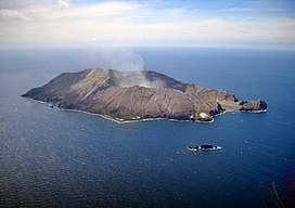
Whakaari / White Island ([faˈkaːɾi], Māori: Te Puia Whakaari, lit. “the dramatic volcano”), also known as White Island or Whakaari, is an active andesite stratovolcano situated 48 km (30 mi) from the east coast of the North Island of New Zealand, in the Bay of Plenty. The island covers an area of approximately 325 ha (800 acres), which is just the peak of a much larger submarine volcano.
The island is New Zealand’s most active cone volcano, and has been built up by continuous volcanic activity over the past 150,000 years. The nearest mainland towns are Whakatane and Tauranga. The island has been in a nearly continuous stage of releasing volcanic gas at least since it was sighted by James Cook in 1769. Whakaari erupted continually from December 1975 until September 2000, and also erupted in 2012, 2016, and 2019.
Sulphur was mined on the island until the 1930s. Ten miners were killed in 1914 when part of the crater wall collapsed.
A large eruption occurred at 14:11 on 9 December 2019, which resulted in 22 fatalities, including two people who were missing and ruled to be dead by a coroner. Twenty-five survivors were seriously injured, many critically and suffering severe burns. Three survivors suffered minor injuries. Forty-seven people were reportedly on the island when it erupted. A second eruption closely followed the first.
Read More About Whakaari / Source
Soufrière Hills
The Soufrière Hills are an active, complex stratovolcano with many lava domes forming its summit on the Caribbean island of Montserrat. After a long period of dormancy, the Soufrière Hills volcano became active in 1995 and has continued to erupt ever since. Its eruptions have rendered more than half of Montserrat uninhabitable, destroying the capital city, Plymouth, and causing widespread evacuations: about two-thirds of the population have left the island. Chances Peak in the Soufrière Hills was the highest summit on Montserrat until the mid-1990s, but it has since been eclipsed by various rising and falling volcanic domes during the recent volcanic activity.The volcano is andesitic in nature, and the current pattern of activity includes periods of lava dome growth, punctuated by brief episodes of dome collapse which result in pyroclastic flows, ash venting, and explosive eruption. The volcano is monitored by the Montserrat Volcano Observatory. Volcanic gas emissions from this volcano are measured by a Multi-Component Gas Analyzer System, which detects pre-eruptive degassing of rising magmas, improving prediction of volcanic activity.The Centre Hills in the central part of the island and the Silver Hills in the north are older volcanic massifs related to the subduction zone. There are three main parts of the island: the central zone, subduction and exclusion.
Read More About Soufrière Hills / Source
Sinabung

Mount Sinabung (Indonesian: Gunung Sinabung, Karo: Deleng Sinabung) is a Pleistocene-to-Holocene stratovolcano of andesite and dacite in the Karo plateau of Karo Regency, North Sumatra, Indonesia, 40 kilometres (25 mi) from the Lake Toba supervolcano. Many old lava flows are on its flanks and the last known eruption, before recent times, occurred 1200 years before present, between 740 – 880 CE. Solfataric activities (cracks where steam, gas, and lava are emitted) were last observed at the summit in 1912; recent documented events include an eruption in the early hours of 29 August 2010 and eruptions in September and November 2013, January, February and October 2014. The volcano has recently claimed the life of at least 23 people in a number of events since 2014. Between 2013 and 2014, the alert for a major event was increased with no significant activity. On 2 June 2015, the alert was again increased, and on 26 June 2015, at least 10,000 people were evacuated, fearing a major eruption. The long eruption of Mount Sinabung is similar to that of Mount Unzen in Japan, which erupted for five years after lying dormant for 400 years. A major eruption began on 10 August 2020.
Read More About Sinabung / Source
Raikoke
Raikoke (Russian: Райкоке, Japanese: 雷公計島), also spelled Raykoke, is, as of 2019 a Russian uninhabited volcanic island near the centre of the Kuril Islands chain in the Sea of Okhotsk in the northwest Pacific Ocean, 16 kilometres (9.9 mi) distant from the island of Matua. Its name is derived from the Ainu language, from “hellmouth”.
Read More About Raikoke / Source
Galeras
Galeras (Urcunina among the 16th-century indigenous people) is an Andean stratovolcano in the Colombian department of Nariño, near the departmental capital Pasto. Its summit rises 4,276 metres (14,029 ft) above sea level. It has erupted frequently since the Spanish conquest, with its first historical eruption being recorded on December 7, 1580. A 1993 eruption killed nine people, including six scientists who had descended into the volcano’s crater to sample gases and take gravity measurements in an attempt to be able to predict future eruptions. It is currently the most active volcano in Colombia.
Read More About Galeras / Source
Kuchinoerabu-jima
Kuchinoerabu-jima (口永良部島), is one of the Satsunan Islands, usually classed with the Ōsumi Islands belonging to Kagoshima Prefecture, Japan. The island, 38.04 km² in area, has a population of 147. The island can only be reached by boat as it has no airport. There is regular ferry service with Yakushima, which is about 15 km to the east. Travel time is approximately 1 hour. The islanders are dependent mainly on fishing, agriculture and seasonal tourism. The entire island is within the borders of the Kirishima-Yaku National Park.
Read More About Kuchinoerabu-jima / Source
Jebel at Tair
Jabal al-Tair Island (or Jebel Teir, Jabal al-Tayr, Tair Island, Al-Tair Island, Jazirat at-Tair) (Arabic: جزيرة جبل الطير Jazīrat Jabal aṭ-Ṭayr, ‘Bird Mountain Island’) is a roughly oval volcanic island in Yemen, northwest of the constricted Bab al-Mandab passage at the mouth of the Red Sea, about halfway between mainland Yemen and Eritrea. From 1996 until it erupted in 2007, Yemen maintained two watchtowers and a small military base on the island.
After 124 years of dormancy, the volcano that created the island erupted on 30 September 2007.
Read More About Jebel at Tair / Source
Hunga Tonga

Hunga Tonga–Hunga Haʻapai (listen ) is a submarine volcano in the South Pacific located about 30 km (19 mi) south of the submarine volcano of Fonuafoʻou and 65 km (40 mi) north of Tongatapu, Tonga’s main island. It is part of the highly active Kermadec-Tonga subduction zone and its associated volcanic arc, which extends from New Zealand north-northeast to Fiji, and is formed by the subduction of the Pacific Plate under the Indo-Australian Plate. It lies about 100 km (62 mi) above a very active seismic zone.The volcano rises around 2,000 m from the seafloor and has a caldera which – on the eve of the 2022 eruption – was roughly 150 m below sea level and 4 km at its widest extent. The only major above-water part of the volcano are the twin uninhabited islands of Hunga Tonga and Hunga Haʻapai, which are respectively part of the northern and western rim of the caldera. As a result of the volcano’s eruptive history, the islands existed as single landmass from 2015 to 2022: they were merged by a volcanic cone in a VEI 2 volcanic eruption in 2014–2015, and were separated again by a more explosive eruption in 2022, which also reduced the islands in size.Its most recent eruption in January 2022 generated a tsunami that reached as far as the coasts of Japan and of the Americas and a volcanic plume that reached 58 km (36 mi) into the mesosphere. As of May 2022 the eruption is the largest volcanic eruption in the 21st century. Hunga Tonga–Hunga Haʻapai likely had a previous major explosive eruption in the late 11th or early 12th century (possibly in 1108). Several known historical eruptions occurred in 1912, 1937, 1988, 2009, 2014–15 and 2021–22.
Read More About Hunga Tonga / Source
Karangetang
Karangetang (also known as Api Siau) is a volcano on the north side of Siau Island off the coast of Sulawesi, Indonesia. The island is inhabited by 22,000 people. It is one of the most active volcanoes in Indonesia having erupted 41 times since 1675. A pyroclastic flow in 1997 killed three people.
Read More About Karangetang / Source
Mount Tavurvur
Tavurvur is an active stratovolcano near Rabaul, on the island of New Britain, in Papua New Guinea. It is a sub-vent of the Rabaul caldera and lies on the eastern rim of the larger feature. An eruption of the volcano largely destroyed the nearby town of Rabaul in 1994.
Mount Tavurvur is the most active volcano in Rabaul caldera, and erupted most recently on 29 August 2014.The correct pronunciation of the volcano’s name is tah-VOOR-voor, according to the Rabaul Volcanological Observatory.
Read More About Mount Tavurvur / Source
Mount Hudson
Mount Hudson (Spanish: Volcán Hudson, Monte Hudson) is a stratovolcano in southern Chile, and the site of one of the largest eruptions in the twentieth century. The mountain itself is covered by a glacier. There is a caldera at the summit from an ancient eruption; modern volcanic activity comes from inside the caldera. Mount Hudson is named after Francisco Hudson, a 19th-century Chilean Navy hydrographer.
Read More About Mount Hudson / Source
Yakedake
Mount Yake (焼岳, Yake-dake) literally, “Burning mountain” is an active volcano in the Hida Mountains, lying between Matsumoto, Nagano Prefecture, and Takayama, Gifu Prefecture, Japan. It is one of the 100 Famous Japanese Mountains, reaching 2,455 m (8,054 ft) at the highest peak.
Read More About Yakedake / Source
Stromboli
Stromboli ( STROM-bə-lee, Italian: [ˈstromboli]; Sicilian: Struògnuli [ˈʂː(ɽ)wɔɲɲʊlɪ]) is an island in the Tyrrhenian Sea, off the north coast of Sicily, containing Mount Stromboli, one of the four active volcanoes in Italy. It is one of the eight Aeolian Islands, a volcanic arc north of Sicily. Strabo writes that people believed that this is where Aeolus lived.The island, with an area of 12.6 square kilometres (4.9 sq mi), represents the upper third of the volcano. Its population was about 500 as of 2016. The volcano has erupted many times and is constantly active with minor eruptions, often visible from many points on the island and from the surrounding sea, giving rise to the island’s nickname “Lighthouse of the Mediterranean”.
Read More About Stromboli / Source
Pacaya

Pacaya is an active complex volcano in Guatemala, which first erupted approximately 23,000 years ago and has erupted at least 23 times since the Spanish conquest of Guatemala. It rises to an elevation of 2,552 metres (8,373 ft). After being dormant for over 70 years, it began erupting vigorously in 1961 and has been erupting frequently since then. Much of its activity is Strombolian, but occasional Plinian eruptions also occur, sometimes showering the area of the nearby Departments with ash.Pacaya is a popular tourist attraction. It is even the home to the popular Guatemala Impact Marathon which pioneered the use of a running route across the lava field created by the 2010 eruption and supports the local communities through runners endeavouring to complete the challenge. It lies 30 kilometers (19 miles) southwest of Guatemala City and close to Antigua. The volcano sits inside the Escuintla Department. Volcano Boarding is also practiced on the craters of Pacaya.Villagers near Pacaya ignored an evacuation request as the volcano threw ashes into the air in March 2021.
Read More About Pacaya / Source
Kanlaon
Kanlaon, also known as Mount Kanlaon and Kanlaon Volcano (Hiligaynon: Bolkang Kanglaon; Cebuano: Bolkang Kanglaon; Filipino: Bulkang Kanlaon), is an active stratovolcano and the highest mountain on the island of Negros in the Philippines, as well as the highest point in the Visayas, with an elevation of 2,465 m (8,087 ft) above sea level. Mount Kanlaon ranks as the 42nd-highest peak of an island in the world.
The volcano straddles the provinces of Negros Occidental and Negros Oriental, approximately 30 km (19 mi) southeast of Bacolod, the capital and most populous city of Negros Occidental and whole island. It is one of the active volcanoes in the Philippines and part of the Pacific Ring of Fire.
Read More About Kanlaon / Source
Didicas
Didicas Volcano is an active volcanic island in the province of Cagayan in northern Philippines. The island, which was a submarine volcano and re-emerged from the sea in 1952, is 22 kilometres (14 mi) NE of Camiguin Island, one of the Babuyan Islands in Luzon Strait. Before 1952, the volcano first breached the ocean surface in 1857.
Read More About Didicas / Source
Santa Ana

The Santa Ana Volcano or Ilamatepec (Spanish: volcán de Santa Ana) is a large stratovolcano located in the Santa Ana department of El Salvador. At 2,381 metres (7,812 ft) above sea level, it is the highest volcano in the country. It is located immediately west of Coatepeque Caldera.
The volcano was the inspiration for one of the active volcanoes in Antoine de Saint-Exupéry’s famous French novella (The Little Prince), based on his life with his Salvadoran wife Consuelo de Saint Exupéry, who was The Rose in the story.
Read More About Santa Ana / Source
Mount Bromo
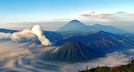
The Bromo (Javanese: ꦧꦿꦩ), or Mount Bromo (Javanese: ꦒꦸꦤꦸꦁꦧꦿꦩ Pegon: ڮنڠ برومو, romanized: Gunung Bromo) is an active somma volcano and part of the Tengger mountains, in East Java, Indonesia. At 2,329 meters (7,641 ft) it is not the highest peak of the massif, but the most famous. The area is one of the most visited tourist destinations in East Java, and the volcano is included in the Bromo Tengger Semeru National Park. The name Bromo comes from the Javanese pronunciation of Brahma, the Hindu god of creation. Mount Bromo is located in the middle of a plain called “Sea of Sand” (Javanese: Segara Wedi or Indonesian: Lautan Pasir), a nature reserve that has been protected since 1919.
A typical way to visit Mount Bromo is from the nearby mountain village of Cemoro Lawang. From there it is possible to walk to the volcano in about 45 minutes, but it is also possible to take an organized jeep tour, including stops at the viewpoint of Mount Penanjakan (2,770 m (9,090 ft)) (Indonesian: Gunung Penanjakan). The sights on Mount Penanjakan can also be reached on foot in about two hours. Depending on the level of volcanic activity, the Indonesian Center for Volcanology and Disaster Mitigation sometimes issues a warning not to visit Mount Bromo.
Read More About Mount Bromo / Source
Popocatépetl
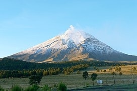
Popocatépetl (Spanish pronunciation: [popokaˈtepetl] (listen); Nahuatl: Popōcatepētl Nahuatl pronunciation: [popoːkaˈtepeːt͡ɬ]) is an active stratovolcano located in the states of Puebla, Morelos, and Mexico in central Mexico. It lies in the eastern half of the Trans-Mexican volcanic belt. At 5,426 m (17,802 ft) it is the second highest peak in Mexico, after Citlaltépetl (Pico de Orizaba) at 5,636 m (18,491 ft).
It is linked to the twin volcano of Iztaccihuatl to the north by the high saddle known as the “Paso de Cortés”. Izta-Popo Zoquiapan National Park, wherein the two volcanoes are located, is named after them.Popocatépetl is 70 km (43 mi) southeast of Mexico City, from where it can be seen regularly, depending on atmospheric conditions. Until recently, the volcano was one of three tall peaks in Mexico to contain glaciers, the others being Iztaccihuatl and Pico de Orizaba. In the 1990s, the glaciers such as Glaciar Norte (North Glacier) greatly decreased in size, partly due to warmer temperatures but largely due to increased volcanic activity. By early 2001, Popocatépetl’s glaciers were gone; ice remained on the volcano, but no longer displayed the characteristic features of glaciers such as crevasses.Lava erupting from Popocatépetl has historically been predominantly andesitic, but it has also erupted large volumes of dacite. Magma produced in the current cycle of activity tends to be a mixture of the two with the andesites being rich in magnesium.
Read More About Popocatépetl / Source
Cumbre Vieja

The Cumbre Vieja (Spanish pronunciation: [ˈkumbɾe ˈβjexa]; meaning “Old Summit”) is an active volcanic ridge on the island of La Palma in the Canary Islands, Spain. The spine of Cumbre Vieja trends in an approximate north–south direction, comprising the southern half of La Palma, with both summit ridge and flanks pockmarked by dozens of craters and cones. The latest eruption began on 19 September 2021 in a forested area of Las Manchas locality known as Cabeza de Vaca. Voluminous lava flows quickly reached populated areas downslope, fanning out across settlements and banana plantations, destroying thousands of buildings and ultimately pouring over steep cliffs into the ocean to enlarge the island at several locations. The volcano went quiet on 13 December 2021, and on 25 December 2021, the local government declared the eruption to be over.Cumbre Vieja erupted twice in the 20th century, in 1949 (Volcán San Juan) and in 1971 (Volcán Teneguía).
Read More About Cumbre Vieja / Source
Chaitén
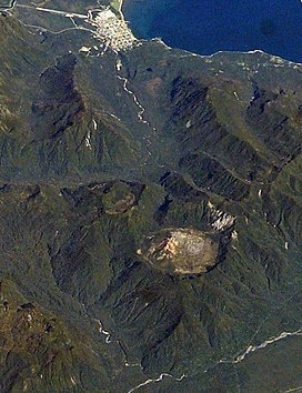
Chaitén is a volcanic caldera 3 kilometres (2 mi) in diameter, 17 kilometres (11 mi) west of the elongated ice-capped Michinmahuida volcano and 10 kilometres (6 mi) northeast of the town of Chaitén, near the Gulf of Corcovado in southern Chile. The most recent eruptive phase of the volcano erupted on 2008. Originally, radiocarbon dating of older tephra from the volcano suggested that its last previous eruption was in 7420 BC ± 75 years. However, recent studies have found that the volcano is more active than thought. According to the Global Volcanism Program, its last eruption was in 2011.The caldera rim reaches 1,122 metres (3,681 ft) above sea level. Before the current eruption, it was mostly filled by a rhyolite obsidian lava dome that reached a height of 962 metres (3,156 ft), partly devoid of vegetation. Two small lakes occupied the caldera floor on the west and north sides of the lava dome.The translucent grey obsidian which had erupted from the volcano was used by pre-Columbian cultures as a raw material for artifacts and has been found as far away as 400 kilometres (250 mi) to the south and north, for example in Chan-Chan.
Read More About Chaitén / Source
Raoul Island
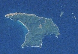
Raoul Island (Sunday Island) is the largest and northernmost of the main Kermadec Islands, 900 km (560 mi) south south-west of ‘Ata Island of Tonga and 1,100 km (680 mi) north north-east of New Zealand’s North Island. It has been the source of vigorous volcanic activity during the past several thousand years that was dominated by dacitic explosive eruptions.
The area of the anvil-shaped island, including fringing islets and rocks mainly in the northeast, but also a few smaller ones in the southeast, is 29.38 km2 (11 sq mi). The highest elevation is Moumoukai Peak, at an elevation of 516 m (1,693 ft).
Although Raoul is the only island in the Kermadec group large enough to support settlement, it lacks a safe harbour, and landings from small boats can be made only in calm weather. The island consists of two mountainous areas, one with summits of 516 metres (1,693 ft) and 498 metres (1,634 ft), and the other with a summit of 465 metres (1,526 ft), the two separated by a depression which is the caldera of the Raoul volcano.
Read More About Raoul Island / Source
Eldfell
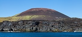
Eldfell is a volcanic cone just over 200 metres (660 ft) high on the Icelandic island of Heimaey. It formed in a volcanic eruption, which began without warning on the eastern side of Heimaey, in the Westman Islands, on 23 January 1973. The name means Hill of Fire in Icelandic.
The eruption caused a major crisis for the island and led to its temporary evacuation. Volcanic ash fell over most of the island, destroying around 400 homes, and a lava flow threatened to close off the harbour, the island’s main income source via its fishing fleet. An operation was mounted to cool the advancing lava flow by pumping sea water onto it, which was successful in preventing the loss of the harbour.
After the eruption, the islanders used heat from the cooling lava flows to provide hot water and to generate electricity. They also used some of the extensive tephra, fall-out of airborne volcanic material to extend the runway at the island’s small airport and as landfill on which 200 new houses were built.
Read More About Eldfell / Source
Keywords:
Most Dangerous and Deadly Volcanic Eruptions Volcanic Eruptions Which Cause Most of the Deaths List of Volcanic Eruptions in the World