10 Largest Deserts In The World

Deserts or deserts are the geographical areas where the waterfall (sum of rain and snow) is much less than other areas. Often (mistakenly) sandy desert plains are called deserts which is incorrect. It is another matter that the region with lowest rainfall in India (Thar) is a sandy plain. It is not necessary for the desert to be sandy. It is also not necessary for the desert to be warm or hot.The Antarctic, which is a region covered with snow, is the largest desert in the world! There are many deserts in other countries of the world which are not sandy. Today we will give you information about some of the largest deserts or deserts in the world –
Antarctica
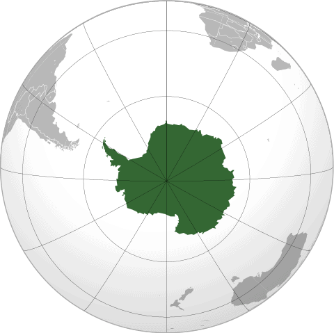
Antarctica is Earth’s southernmost continent. It contains the geographic South Pole and is situated in the Antarctic region of the Southern Hemisphere, almost entirely south of the Antarctic Circle, and is surrounded by the Southern Ocean. At 14,200,000 square kilometres (5,500,000 square miles), it is the fifth-largest continent and nearly twice the size of Australia. At 0.00008 people per square kilometre, it is by far the least densely populated continent. About 98% of Antarctica is covered by ice that averages 1.9 km (1.2 mi; 6,200 ft) in thickness, which extends to all but the northernmost reaches of the Antarctic Peninsula.
Antarctica, on average, is the coldest, driest, and windiest continent, and has the highest average elevation of all the continents. Most of Antarctica is a polar desert, with annual precipitation of 200 mm (7.9 in) along the coast and far less inland; there has been no rain there for almost 2 million years, yet 80% of the world freshwater reserves are stored there, enough to raise global sea levels by about 60 metres (200 ft) if all of it were to melt. The temperature in Antarctica has reached −89.2 °C (−128.6 °F) (or even −94.7 °C (−135.8 °F) as measured from space), though the average for the third quarter (the coldest part of the year) is −63 °C (−81 °F). Anywhere from 1,000 to 5,000 people reside throughout the year at research stations scattered across the continent. Organisms native to Antarctica include many types of algae, bacteria, fungi, plants, protista, and certain animals, such as mites, nematodes, penguins, seals and tardigrades. Vegetation, where it occurs, is tundra.
Antarctica is noted as the last region on Earth in recorded history to be discovered, unseen until 1820 when the Russian expedition of Fabian Gottlieb von Bellingshausen and Mikhail Lazarev on Vostok and Mirny sighted the Fimbul ice shelf. The continent, however, remained largely neglected for the rest of the 19th century because of its hostile environment, lack of easily accessible resources, and isolation. In January 1840, terra firma at Antarctica was discovered for the first time, almost simultaenously, by the United States Exploring Expedition, under Lieut. Charles Wilkes, and a separate French expedition under Jules Dumont d’Urville. The latter in its brief sojourn actually made a temporary landing; while the Wilkes expedition, though it did not make a landing, did remain long enough in the region to survey and map some 800 miles of the continent. In 1895, the first confirmed landing was conducted by a team of Norwegians.
Antarctica is a de facto condominium, governed by parties to the Antarctic Treaty System that have consulting status. Twelve countries signed the Antarctic Treaty in 1959, and thirty-eight have signed it since then. The treaty prohibits military activities and mineral mining, prohibits nuclear explosions and nuclear waste disposal, supports scientific research, and protects the continent’s ecology. Ongoing experiments are conducted by more than 4,000 scientists from many nations.
Read More About Antarctica / Source
Sahara
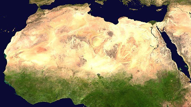
The Sahara is a desert on the African continent. With an area of 9,200,000 square kilometres (3,600,000 sq mi), it is the largest hot desert in the world and the third largest desert overall, smaller only than the deserts of Antarctica and the Arctic. The name ‘Sahara’ is derived from the Arabic word for “desert”, ṣaḥra (صحرا /ˈsˤaħra/), plural . (Arabic صَحْرَاء ṣaḥrā’ “desert”, plural صَحَارَى ṣaḥārā “deserts”)
The desert comprises much of North Africa, excluding the fertile region on the Mediterranean Sea coast, the Atlas Mountains of the Maghreb, and the Nile Valley in Egypt and Sudan. It stretches from the Red Sea in the east and the Mediterranean in the north to the Atlantic Ocean in the west, where the landscape gradually changes from desert to coastal plains. To the south, it is bounded by the Sahel, a belt of semi-arid tropical savanna around the Niger River valley and the Sudan Region of Sub-Saharan Africa. The Sahara can be divided into several regions, including the western Sahara, the central Ahaggar Mountains, the Tibesti Mountains, the Aïr Mountains, the Ténéré desert, and the Libyan Desert.
For several hundred thousand years, the Sahara has alternated between desert and savanna grassland in a 20,000 year cycle caused by the precession of the Earth’s axis as it rotates around the Sun, which changes the location of the North African Monsoon. The area is next expected to become green in about 15,000 years (17,000 CE).
Read More About Sahara / Source
Arctic desert

The Arctic desert ecoregion (WWF ID:PA1101) is a terrestrial ecoregion that covers the island groups of Svalbard, Franz Josef Land, Severny Island and Severnaya Zemlya in the Arctic Ocean, above 75 degrees north latitude. The region is covered with glaciers, snow, and bare rock in a harshly cold environment. The temperature does rise above freezing for short periods in the summer, so some ice melt occurs, and the area supports colonies of sea birds and mammals. It has an area of 161,400 square kilometres (62,300 sq mi).
Read More About Arctic desert / Source
Arabian Desert

The Arabian Desert is a vast desert wilderness in Western Asia. It stretches from Yemen to the Persian Gulf and Oman to Jordan and Iraq. It occupies most of the Arabian Peninsula, with an area of 2,330,000 square kilometers (900,000 sq mi). It is the fifth largest desert in the world, and the largest in Asia. At its center is Ar-Rub’al-Khali (The Empty Quarter), one of the largest continuous bodies of sand in the world.
Gazelles, oryx, sand cats, and spiny-tailed lizards are just some of the desert-adapted species that survive in this extreme environment, which features everything from red dunes to deadly quicksand. The climate is mostly dry (the major part receives around 100 mm (3.9 in) of rain per year but some very rare places receive as little as 50 mm), and temperatures oscillate between very high heat and seasonal night time freezes. It is part of the deserts and xeric shrublands biome and the Palearctic realm.
The Arabian desert ecoregion holds little biodiversity, although a few endemic plants grow here. Many species, such as the striped hyena, jackal and honey badger have become extirpated due to hunting, human encroachment and habitat destruction. Other species have been successfully re-introduced, such as the Arabian sand gazelle, and are protected at a number of reserves. Overgrazing by livestock, off-road driving, and human destruction of habitat are the main threats to this desert ecoregion.
Read More About Arabian Desert / Source
Gobi Desert
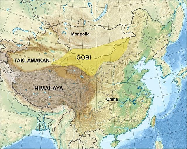
The Gobi Desert is a large desert or brushland region in East Asia. It covers parts of Northern and Northeastern China and of Southern Mongolia. The desert basins of the Gobi are bounded by the Altai Mountains and the grasslands and steppes of Mongolia on the north, by the Taklamakan Desert to the west, by the Hexi Corridor and Tibetan Plateau to the southwest and by the North China Plain to the southeast. The Gobi is notable in history as the location of several important cities along the Silk Road.
The Gobi is a rain shadow desert, formed by the Tibetan Plateau blocking precipitation from the Indian Ocean reaching the Gobi territory.
More recently, Gobi Desert has also witnessed desert sporting events from enthusiasts such as “The Gobi Desert Cup”. Founded in 2016 by FEI 3* Endurance Rider, Camille Champagne, the Gobi Desert Cup is a multi-stage endurance ride and cultural experience through the Gobi Desert, riding trained and conditioned Mongolian horses every day for six days over a total of 480 kilometers (300 mi). In 2016, ultra runner Dion Leonard was running a 155 mile race across the Gobi Desert when a little stray dog, named Gobi (dog) ran with him for 77 miles.
Read More About Gobi Desert / Source

Patagonian Desert
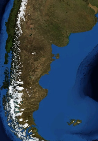
The Patagonian Desert, also known as the Patagonian Steppe is the largest desert in Argentina and is the 8th largest desert in the world by area, occupying 673,000 square kilometers (260,000 mi2). It is located primarily in Argentina and is bounded by the Andes, to its west, and the Atlantic Ocean to its east, in the region of Patagonia, southern Argentina. To the north the desert grades into the Cuyo Region and the Monte. The central parts of the steppe are dominated by shrubby and herbaceous plant species albeit to the west, where precipitation is higher, bushes are replaced by grasses. Topographically the deserts consist of alternating tablelands and massifs dissected by river valleys and canyons. The more western parts of the steppe host lakes of glacial origin and grades into barren mountains or cold temperate forests along valleys.
Inhabited by hunter-gatherers since Pre-Hispanic times, the desert faced migration in the 19th century of Argentines, Welsh, and other European peoples, transforming it from a conflictive borderland zone to an integral part of Argentina, with cattle, sheep and horse husbandry being the primary land uses.
The Patagonian Desert has existed since the Middle Miocene (14–12 million years ago) and came into existence as the Andes rose to the west.
Read More About Patagonian Desert / Source
Kalahari Desert

The Kalahari Desert is a large semi-arid sandy savannah in Southern Africa extending for 900,000 square kilometres (350,000 sq mi), covering much of Botswana, and parts of Namibia and South Africa.
It is not to be confused with the Angolan, Namibian, and South African Namib coastal desert, whose name is of Khoekhoegowab origin and means “vast place”.
Read More About Kalahari Desert / Source
Syrian Desert
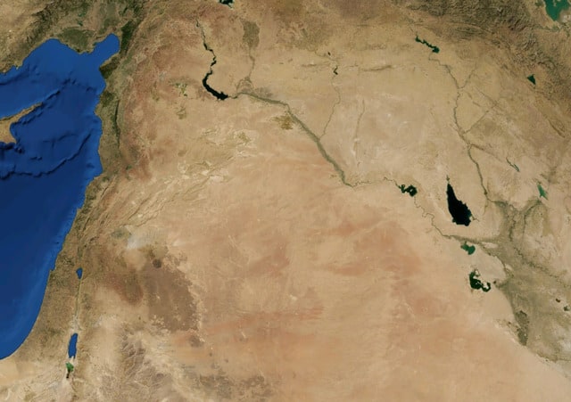
The Syrian Desert, also known as the Syrian steppe, the Jordanian steppe, or the Badia, is a region of desert, semi-desert and steppe covering 500,000 square kilometers (200,000 square miles) of the Middle East, including parts of south-eastern Syria, northeastern Jordan, northern Saudi Arabia, and western Iraq. It accounts for 85% of the land area of Jordan and 55% of Syria. To the south it borders and merges into the Arabian Desert. The land is open, rocky or gravelly desert pavement, cut with occasional wadis.
Read More About Syrian Desert / Source
Great Victoria Desert

The Great Victoria Desert is a sparsely-populated desert ecoregion and interim Australian bioregion in Western Australia and South Australia. The Great Victoria is the largest desert in Australia, and consists of many small sandhills, grassland plains, areas with a closely packed surface of pebbles (called desert pavement or gibber plains), and salt lakes. It is over 700 km (430 mi) wide (from west to east) and covers an area of 348,750 km2 (134,650 sq mi) from the Eastern Goldfields region of Western Australia to the Gawler Ranges in South Australia. The Western Australian mulga shrublands ecoregion lies to the west, the Little Sandy Desert to the northwest, the Gibson Desert and the Central Ranges xeric shrublands to the north, the Tirari-Sturt stony desert to the east, and the Nullarbor Plain to the south separates it from the Southern Ocean. Average annual rainfall is low and irregular, ranging from 200 to 250 mm (7.9 to 9.8 in) per year. Thunderstorms are relatively common in the Great Victoria Desert, with an average of 15–20 thunderstorms yearly. Summer daytime temperatures range from 32 to 40 °C (90 to 104 °F), while in winter, this falls to 18 to 23 °C (64 to 73 °F). The Great Victoria desert is a World Wildlife Fund ecoregion and an Interim Biogeographic Regionalisation for Australia region of the same name.
Read More About Great Victoria Desert / Source
Great Basin Desert
The Great Basin Desert is part of the Great Basin between the Sierra Nevada and the Wasatch Range. The desert is a geographical region that largely overlaps the Great Basin shrub steppe defined by the World Wildlife Fund, and the Central Basin and Range ecoregion defined by the U.S. Environmental Protection Agency and United States Geological Survey. It is a temperate desert with hot, dry summers and snowy winters. The desert spans a large part of the state of Nevada, and extends into western Utah, eastern California, and Idaho. The desert is one of the four biologically defined deserts in North America, in addition to the Mojave, Sonoran, and Chihuahuan Deserts.Basin and range topography characterizes the desert: wide valleys bordered by parallel mountain ranges generally oriented north-south. There are more than 33 peaks within the desert with summits higher than 9,800 feet (3,000 m), but valleys in the region are also high, most with elevations above 3,900 feet (1,200 m). The biological communities of the Great Basin Desert vary according to altitude: from low salty dry lakes, up through rolling sagebrush valleys, to pinyon-juniper forests. The significant variation between valleys and peaks has created a variety of habitat niches, which has in turn led to many small, isolated populations of genetically unique plant and animal species throughout the region. According to Grayson, more than 600 species of vertebrates live in the floristic Great Basin, which has a similar areal footprint to the ecoregion. Sixty-three of these species have been identified as species of conservation concern due to contracting natural habitats (for example, Centrocercus urophasianus, Vulpes macrotis, Dipodomys ordii, and Phrynosoma platyrhinos).The ecology of the desert varies across geography, also. The desert’s high elevation and location between mountain ranges influences regional climate: the desert formed by the rain shadow of the Sierra Nevada that blocks moisture from the Pacific Ocean, while the Rocky Mountains create a barrier effect that restricts moisture from the Gulf of Mexico. Different locations in the desert have different amounts of precipitation, depending on the strength of these rain shadows. The environment is influenced by Pleistocene lakes that dried after the last ice age: Lake Lahontan and Lake Bonneville. Each of these lakes left different amounts of salinity and alkalinity.
Read More About Great Basin Desert / Source
Keywords:
Largest Deserts In The World World's Largest Deserts Biggest Deserts in the World World's Biggest Deserts