Raoul Island
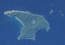
Raoul Island (Sunday Island) is the largest and northernmost of the main Kermadec Islands, 900 km (560 mi) south south-west of ‘Ata Island of Tonga and 1,100 km (680 mi) north north-east of New Zealand’s North Island. It has been the source of vigorous volcanic activity during the past several thousand years that was dominated by dacitic explosive eruptions.
The area of the anvil-shaped island, including fringing islets and rocks mainly in the northeast, but also a few smaller ones in the southeast, is 29.38 km2 (11 sq mi). The highest elevation is Moumoukai Peak, at an elevation of 516 m (1,693 ft).
Although Raoul is the only island in the Kermadec group large enough to support settlement, it lacks a safe harbour, and landings from small boats can be made only in calm weather. The island consists of two mountainous areas, one with summits of 516 metres (1,693 ft) and 498 metres (1,634 ft), and the other with a summit of 465 metres (1,526 ft), the two separated by a depression which is the caldera of the Raoul volcano.