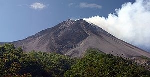
Mount Merapi
Mount Merapi, Gunung Merapi (literally Fire Mountain in Indonesian and Javanese), is an active stratovolcano located on the border between the province of Central Java and the Special Region of Yogyakarta, Indonesia. It is the most active volcano in Indonesia and has erupted regularly since 1548. It is located approximately 28 km (17 mi) north of Yogyakarta city which has a population of 2.4 million, and thousands of people live on the flanks of the volcano, with villages as high as 1,700 m (5,577 ft) above sea level.
Smoke can often be seen emerging from the mountaintop, and several eruptions have caused fatalities. A pyroclastic flow from a large explosion killed 27 people on 22 November 1994, mostly in the town of Muntilan, west of the volcano. Another large eruption occurred in 2006, shortly before the Yogyakarta earthquake. In light of the hazards that Merapi poses to populated areas, it was designated as one of the Decade Volcanoes.
On the afternoon of 25 October 2010, Merapi erupted on its southern and southeastern slopes. A total of 353 people were killed over the next month, while 350,000 were forced to flee their homes; most of the damage was done by pyroclastic flows, while heavy rain on 4 November created lahars which caused further damage. Most of the fissures had ceased erupting by 30 November, and four days later the official threat level was lowered. Merapi’s characteristic shape was changed during the eruptions, with its height lowered 38 m (125 ft) to 2,930 m (9,613 ft).Since 2010, Merapi had experienced several smaller eruptions, most noticeably two phreatic eruptions which occurred on 18 November 2013 and 11 May 2018. The first and larger of these, caused by a combination of rainfall and internal activity, saw smoke issued up to a height of 2,000 m (6,562 ft). There have been several small eruptions since the beginning of 2020, which are of great interest to volcanologists.